world.wikisort.org - Japan
Kyōtanabe (京田辺市, Kyōtanabe-shi) is a city located in the southern part of Kyoto Prefecture, Japan. As of October 1, 2020 the city has an estimated population of 73,753 and a population density of 1,718 persons per km². The total area is 42.92 km².
Kyōtanabe
京田辺市 | |
|---|---|
City | |
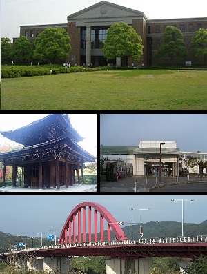 Top:A campus of Doshisha University, Middle left:Shuonan Temple, Middle right:Matsui Yamate Station, Bottom:Yamashiro Bridge | |
 Flag  Emblem | |
 Location of Kyōtanabe in Kyoto Prefecture | |
 Kyōtanabe Location in Japan | |
| Coordinates: 34°49′N 135°46′E | |
| Country | Japan |
| Region | Kansai |
| Prefecture | Kyoto Prefecture |
| First official recorded | 5th century AD |
| City settled | April 1, 1997 |
| Government | |
| • Mayor | Takashi Kamimura (since April 2019) |
| Area | |
| • Total | 42.92 km2 (16.57 sq mi) |
| Population (October 1, 2020) | |
| • Total | 73,753 |
| • Density | 1,700/km2 (4,500/sq mi) |
| Time zone | UTC+09:00 (JST) |
| City hall address | Tanabe 80, Kyo-tanabe City, Kyoto Prefecture (京都府京田辺市田辺80番地) 610-0393 |
| Climate | Cfa |
| Website | www |
| Symbols | |
| Flower | Rhododendron pulchrum |
| Tree | Triadica sebifera |
History
Kyōtanabe was briefly the capital of Japan during the reign of Emperor Keitai. The life of the Imperial court was centered at Tsutsuki Palace where the emperor lived in 511–518.[1]
The modern city was founded on April 1, 1997, after the town of Tanabe was reorganized into the city of Kyōtanabe. The Kyō- was added to distinguish it from the city of Tanabe, Wakayama.
Geography

Climate
Kyōtanabe has a humid subtropical climate (Köppen Cfa), featuring a marked seasonal variation in temperature and precipitation. Summers are hot and humid, but winters are relatively cold with occasional snowfall. The average annual temperature in Kyōtanabe is 15.3 °C (59.5 °F). The average annual rainfall is 1,429.8 mm (56.29 in) with June as the wettest month. The temperatures are highest on average in August, at around 27.5 °C (81.5 °F), and lowest in January, at around 4.1 °C (39.4 °F).[2] Its record high is 39.0 °C (102.2 °F), reached on 16 August 2007, and its record low is −6.8 °C (19.8 °F), reached on 27 February 1981.[3]
| Climate data for Kyōtanabe (1991−2020 normals, extremes 1978−present) | |||||||||||||
|---|---|---|---|---|---|---|---|---|---|---|---|---|---|
| Month | Jan | Feb | Mar | Apr | May | Jun | Jul | Aug | Sep | Oct | Nov | Dec | Year |
| Record high °C (°F) | 17.6 (63.7) |
22.4 (72.3) |
25.9 (78.6) |
30.6 (87.1) |
33.5 (92.3) |
37.5 (99.5) |
38.4 (101.1) |
39.0 (102.2) |
37.0 (98.6) |
32.7 (90.9) |
26.5 (79.7) |
23.3 (73.9) |
39.0 (102.2) |
| Average high °C (°F) | 9.1 (48.4) |
10.0 (50.0) |
13.9 (57.0) |
19.9 (67.8) |
24.9 (76.8) |
28.0 (82.4) |
31.8 (89.2) |
33.4 (92.1) |
29.0 (84.2) |
23.2 (73.8) |
17.2 (63.0) |
11.6 (52.9) |
21.0 (69.8) |
| Daily mean °C (°F) | 4.1 (39.4) |
4.6 (40.3) |
8.0 (46.4) |
13.5 (56.3) |
18.6 (65.5) |
22.6 (72.7) |
26.5 (79.7) |
27.5 (81.5) |
23.4 (74.1) |
17.4 (63.3) |
11.3 (52.3) |
6.2 (43.2) |
15.3 (59.6) |
| Average low °C (°F) | −0.6 (30.9) |
−0.4 (31.3) |
2.3 (36.1) |
7.2 (45.0) |
12.6 (54.7) |
18.0 (64.4) |
22.4 (72.3) |
23.0 (73.4) |
18.9 (66.0) |
12.4 (54.3) |
6.2 (43.2) |
1.4 (34.5) |
10.3 (50.5) |
| Record low °C (°F) | −6.6 (20.1) |
−6.8 (19.8) |
−4.1 (24.6) |
−2.1 (28.2) |
0.2 (32.4) |
6.7 (44.1) |
13.8 (56.8) |
14.5 (58.1) |
9.1 (48.4) |
2.6 (36.7) |
−1.8 (28.8) |
−5.1 (22.8) |
−6.8 (19.8) |
| Average precipitation mm (inches) | 51.0 (2.01) |
63.4 (2.50) |
108.0 (4.25) |
106.8 (4.20) |
141.0 (5.55) |
204.2 (8.04) |
181.5 (7.15) |
152.3 (6.00) |
156.9 (6.18) |
140.0 (5.51) |
74.0 (2.91) |
56.9 (2.24) |
1,429.8 (56.29) |
| Average precipitation days (≥ 1.0 mm) | 6.0 | 6.6 | 10.0 | 10.0 | 9.9 | 12.0 | 11.4 | 8.7 | 10.7 | 9.4 | 6.7 | 6.5 | 107.9 |
| Mean monthly sunshine hours | 130.5 | 127.8 | 167.2 | 186.3 | 201.9 | 155.0 | 170.9 | 216.7 | 163.3 | 162.8 | 141.4 | 138.0 | 1,961.8 |
| Source: Japan Meteorological Agency[3][2] | |||||||||||||
Demographics
Per Japanese census data, the population of Kyōtanabe in 2020 is 73,753 people.[4] Kyōtanabe's population has increased roughly sevenfold over the past century. The city has grown almost continuously since the census began in 1920, and saw especially rapid growth in the late 20th century.
|
| |||||||||||||||||||||||||||||||||||||||||||||||||||||||||||||||||||||
| Kyōtanabe population statistics[4] | ||||||||||||||||||||||||||||||||||||||||||||||||||||||||||||||||||||||
Education
- Doshisha Women's College of Liberal Arts
- Doshisha Women's Junior College
Notable people from Kyōtanabe, Kyoto
- Kenji Takao, Japanese running coach and former long-distance runner (10,000 metres)
- Takuya Muguruma, Japanese former football player
- Akinari Kawazura, Japanese football player (Omiya Ardija, J2 League)
- Meg Hemphill, Japanese track and field athlete
- Momo Hirai, Japanese singer, dancer, model, MC, member of South Korean girl group Twice
References
- Koch, W. (1904). Japan; Geschichte nach japanischen Quellen und ethnographische Skizzen. Mit einem Stammbaum des Kaisers von Japan, p. 13.
- 気象庁 / 平年値(年・月ごとの値). JMA. Retrieved March 28, 2022.
- 観測史上1~10位の値(年間を通じての値). JMA. Retrieved March 28, 2022.
- Kyōtanabe population statistics
External links
 Media related to Kyōtanabe, Kyoto at Wikimedia Commons
- Kyotanabe City official website (in Japanese)
- Kyotanabe City official website (in English)
This Kyoto Prefecture location article is a stub. You can help Wikipedia by expanding it. |
На других языках
[de] Kyōtanabe
Kyōtanabe (japanisch 京田辺市, -shi) ist eine japanische Stadt im Süden der Präfektur Kyōto.- [en] Kyōtanabe, Kyoto
[es] Kyōtanabe (Kioto)
Kyōtanabe (京田辺市, Kyōtanabe-shi?) es una ciudad localizada en la prefectura de Kioto, Japón. En junio de 2019 tenía una población de 73.433 habitantes y una densidad de población de 1.711 personas por km². Su área total es de 42,92 km².[ru] Кётанабе
Кётанабе (яп. 京田辺市 Кё:танабэ-си) — город в Японии, находящийся в префектуре Киото. Площадь города составляет 42,92 км²[1], население — 73 773 человека (1 октября 2020)[2], плотность населения — 1718,85 чел./км².Другой контент может иметь иную лицензию. Перед использованием материалов сайта WikiSort.org внимательно изучите правила лицензирования конкретных элементов наполнения сайта.
WikiSort.org - проект по пересортировке и дополнению контента Википедии