world.wikisort.org - Japan
Kamigyō-ku (上京区) is one of the eleven wards in the city of Kyoto, in Kyoto Prefecture, Japan. Located in the center of the present-day city of Kyoto, Japan it previously occupied the northern region of the ancient capital of Kyoto. The Kamo River flows on the eastern border of the ward. The area was previously a district of residences for the royalty and upper classes in the old capital.
This article needs additional citations for verification. (November 2015) |
Kamigyō
上京区 | |
|---|---|
Ward of Kyoto | |
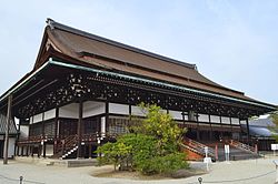
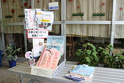
  Top: The Shishinden is a majestic building in the Kyoto Imperial Palace. Bottom: An Exchange Corner at a kiosk in Demachi Shoutenkai featuring characters from Tamako Market. | |
 Location of Kamigyō-ku in Kyoto | |
 Kamigyō Location of Kamigyō-ku in Japan | |
| Coordinates: 35°1′47″N 135°45′24″E | |
| Country | Japan |
| Prefecture | Kyoto |
| City | Kyoto |
| Founded | 1879 |
| Area | |
| • Total | 7.03 km2 (2.71 sq mi) |
| Highest elevation | 77 m (253 ft) |
| Lowest elevation | 46 m (151 ft) |
| Population (October 1, 2020) | |
| • Total | 83,832 |
| • Density | 12,000/km2 (31,000/sq mi) |
| Time zone | UTC+9 (Japan Standard Time) |
| Website | www |
The ward is home to the Kyoto Imperial Palace, the Kitano Tenmangu Shinto shrine, the Seimei shrine, nishijin-ori textiles, and the headquarters of the Omotesenke and Urasenke schools of Japanese tea ceremony.
As of 2020, Kamigyō-ku had a population of 83,832 people.
The Masugata Shōtengai Shopping District, is the setting of the 2013 anime series, Tamako Market, produced by Kyoto Animation.
Demographics
| Year | Pop. | ±% |
|---|---|---|
| 1960 | 148,427 | — |
| 1970 | 124,456 | −16.2% |
| 1980 | 99,262 | −20.2% |
| 1990 | 87,861 | −11.5% |
| 2000 | 84,187 | −4.2% |
| 2010 | 83,264 | −1.1% |
| 2020 | 83,832 | +0.7% |
| Source: | ||
Education
This section needs expansion. You can help by adding to it. (April 2015) |
- Doshisha University
- Kyoto Prefectural University of Medicine
- Heian Jogakuin University
- Imadegawa Campus of Doshisha Women's College of Liberal Arts
The Lycée Français de Kyoto, the French international school in Kansai, was in this ward.[1]
Kyoto International School is also in this ward.[2]
References
- "Accès et contact Archived 2015-04-26 at archive.today." Lycée Français de Kyoto. Retrieved on 26 April 2015. "536-1 WARAYA-CHO MARUTAMACHI DORI KUROMON HIGASHI IRU KAMIGYO-KU 602-8144 KYOTO, JAPON"
- "Find Us Archived 2015-12-20 at the Wayback Machine." Kyoto International School. Retrieved on August 17, 2015. "317 Kitatawara-cho, Kamigyo-ku, Kyoto, Japan 602-8247"
External links
![]() Media related to Kamigyō-ku, Kyoto at Wikimedia Commons
Media related to Kamigyō-ku, Kyoto at Wikimedia Commons
- Official website (in Japanese)
- Kamigyo Ward mascot character, Kamigyukun (in Japanese)
На других языках
[de] Kamigyō-ku (Kyōto)
Kamigyō-ku (japanisch 上京区, deutsch „oberer Hauptstadtbezirk“) ist einer von elf Stadtbezirken (ku) von Kyōto, Japan. Er liegt etwa in der Mitte des heutigen Kyoto und bildet den nördlichen Teil der historischen Innenstadt. Die östliche Grenze des Stadtbezirks verläuft entlang dem Fluss Kamo.- [en] Kamigyō-ku
[ru] Камигё (Киото)
Камигё (яп. 上京区, かみぎょうく [kamʲigʲoː ku]) — район города Киото префектуры Киото в Японии. По состоянию на 1 июля 2012 года население района составило 83 406 человек, плотность населения — 11 730чел / км ².Другой контент может иметь иную лицензию. Перед использованием материалов сайта WikiSort.org внимательно изучите правила лицензирования конкретных элементов наполнения сайта.
WikiSort.org - проект по пересортировке и дополнению контента Википедии