world.wikisort.org - Japan
Fukuchiyama (福知山市, Fukuchiyama-shi) is a city in northern Kyoto Prefecture, Japan. As of 31 March 2022[update], the city had an estimated population of 76,037 in 36412 households and a population density of 140 persons per km².[1] The total area of the city is 697.55 square kilometres (269.33 sq mi).
Fukuchiyama
福知山市 | |
|---|---|
City | |
 Fukuchiyama City Hall | |
 Flag  Emblem | |
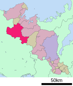 Location of Fukuchiyama in Kyōto Prefecture | |
 Fukuchiyama Location in Japan | |
| Coordinates: 35°18′N 135°8′E | |
| Country | Japan |
| Region | Kansai |
| Prefecture | Kyōto |
| Government | |
| • Mayor | Kazuo Ohashi |
| Area | |
| • Total | 552.54 km2 (213.34 sq mi) |
| Population (March 21, 2022) | |
| • Total | 76,037 |
| • Density | 140/km2 (360/sq mi) |
| Time zone | UTC+09:00 (JST) |
| City hall address | 13-1 Naiki, Fukuchiyama-shi 620-8501 |
| Climate | Cfa |
| Website | Official website |
| Symbols | |
| Bird |
|
| Flower |
|
| Tree | |

Geography
Fukuchiyama is located in northwestern Kyoto Prefecture, bordering Hyogo Prefecture to the west. It is centered on the Fukuchiyama Basin formed by the Yura River, and is surrounded by mountains to the south, west, and east. It is located about 70 kilometers from downtown Osaka, 60 kilometers from Kyoto or Kobe City, and about 30 kilometers from Toyooka or Maizuru. The highest elevation in the city is 839.17 meters above sea level, and the lowest is 7.11meters. The city center extends along the Yura River.
Neighbouring municipalities
Kyoto Prefecture
Hyōgo Prefecture
Climate
Fukuchiyama has a humid subtropical climate (Köppen Cfa), featuring a marked seasonal variation in temperature and precipitation. Summers are hot and humid, but winters are relatively cold with occasional snowfall. The average annual temperature in Fukuchiyama is 14.6 °C (58.3 °F). The average annual rainfall is 1,623.8 mm (63.93 in) with September as the wettest month. The temperatures are highest on average in August, at around 27.0 °C (80.6 °F), and lowest in January, at around 3.2 °C (37.8 °F).[2] Its record high is 39.6 °C (103.3 °F), reached on 22 August 2018, and its record low is −10.0 °C (14.0 °F), reached on 16 February 1977.[3]
| Climate data for Fukuchiyama (1991−2020 normals, extremes 1976−present) | |||||||||||||
|---|---|---|---|---|---|---|---|---|---|---|---|---|---|
| Month | Jan | Feb | Mar | Apr | May | Jun | Jul | Aug | Sep | Oct | Nov | Dec | Year |
| Record high °C (°F) | 17.6 (63.7) |
22.1 (71.8) |
25.1 (77.2) |
31.1 (88.0) |
33.6 (92.5) |
35.4 (95.7) |
38.8 (101.8) |
39.6 (103.3) |
38.3 (100.9) |
32.5 (90.5) |
26.0 (78.8) |
23.4 (74.1) |
39.6 (103.3) |
| Average high °C (°F) | 7.9 (46.2) |
8.9 (48.0) |
13.1 (55.6) |
19.4 (66.9) |
24.4 (75.9) |
27.3 (81.1) |
31.1 (88.0) |
32.8 (91.0) |
28.0 (82.4) |
22.2 (72.0) |
16.3 (61.3) |
10.5 (50.9) |
20.2 (68.3) |
| Daily mean °C (°F) | 3.2 (37.8) |
3.8 (38.8) |
7.2 (45.0) |
12.7 (54.9) |
17.9 (64.2) |
21.8 (71.2) |
25.9 (78.6) |
27.0 (80.6) |
22.7 (72.9) |
16.5 (61.7) |
10.7 (51.3) |
5.5 (41.9) |
14.6 (58.2) |
| Average low °C (°F) | −0.2 (31.6) |
−0.1 (31.8) |
2.1 (35.8) |
6.7 (44.1) |
12.2 (54.0) |
17.5 (63.5) |
22.1 (71.8) |
22.9 (73.2) |
18.8 (65.8) |
12.4 (54.3) |
6.5 (43.7) |
1.8 (35.2) |
10.2 (50.4) |
| Record low °C (°F) | −9.8 (14.4) |
−10.0 (14.0) |
−6.4 (20.5) |
−3.0 (26.6) |
1.9 (35.4) |
7.5 (45.5) |
12.8 (55.0) |
15.2 (59.4) |
7.2 (45.0) |
2.1 (35.8) |
−3.0 (26.6) |
−7.3 (18.9) |
−10.0 (14.0) |
| Average precipitation mm (inches) | 103.9 (4.09) |
96.5 (3.80) |
115.4 (4.54) |
114.1 (4.49) |
137.5 (5.41) |
163.9 (6.45) |
197.5 (7.78) |
166.7 (6.56) |
214.1 (8.43) |
149.6 (5.89) |
82.9 (3.26) |
89.5 (3.52) |
1,623.8 (63.93) |
| Average precipitation days (≥ 1.0 mm) | 14.8 | 13.8 | 13.6 | 10.5 | 10.6 | 11.5 | 12.4 | 9.1 | 11.1 | 9.9 | 10.0 | 13.1 | 140.4 |
| Mean monthly sunshine hours | 91.1 | 92.3 | 129.6 | 164.2 | 175.5 | 127.3 | 140.7 | 176.7 | 119.0 | 121.2 | 105.0 | 96.7 | 1,547.4 |
| Source: Japan Meteorological Agency[3][2] | |||||||||||||
Demographics
Per Japanese census data,[4] the population of Fukuchiyama has remained relatively stable over the past 60 years.
| Year | Pop. | ±% |
|---|---|---|
| 1960 | 87,151 | — |
| 1970 | 76,844 | −11.8% |
| 1980 | 81,398 | +5.9% |
| 1990 | 82,791 | +1.7% |
| 2000 | 83,120 | +0.4% |
| 2010 | 79,668 | −4.2% |
| 2020 | 77,306 | −3.0% |
History
Fukuchiyama is part of ancient Tanba Province. From various excavated items, people have been living along the Yura River since at least the Jōmon period and the area was a transportation hub since ancient times. In the Heian period, the Fukuchiyama basin was developed into a number of shōen landed estates by the Five regent houses in Kyoto. In the Sengoku period, the area came under the control of Akechi Mitsuhide and a castle town developed around Fukuchiyama Castle. In the Edo Period, it was the center of Fukuchiyama Domain, which was ruled by a succession of fudai daimyō. After the Meiji restoration, the town of Fukuchiyama was established on April 1, 1889 with the creation of the modern municipalities system. It was raised to city status on April 1, 1937, becoming the third city in Kyoto Prefecture after Kyoto and Fushimi. The city borders expanded in 1936, 1949, 1955. On January 1, 2006, the towns of Miwa and Yakuno (both from Amata District), and the town of Ōe (from Kasa District) were merged into Fukuchiyama. Amata District was abolished by this merger.
Government
Fukuchiyama has a mayor-council form of government with a directly elected mayor and a unicameral city council of 24 members. Fukuchiyama contributes two members to the Kyoto Prefectural Assembly. In terms of national politics, the city is part of the Kyoto 5th district of the lower house of the Diet of Japan.
Economy
Fukuchiyama has a mixed economy with commerce, light manufacturing and agriculture. Traditionally, the local economy was noted for indigo dying, cotton and silk production; however, the city industrialized as a supplier of components for the military. Postwar, a number of industrial parks, notably the Osadano Industrial Park, have developed.
Education
Fukuchiyama has 19 public elementary schools and eight public middle schools and one combined elementary/middle school operated by the city government and two public high schools and one combined middle/high school operated by the Kyoto Prefectural Department of Education. There are also two private high schools and one private combined middle high school. The prefecture also operates one special education school for the handicapped. A private college, the University of Fukuchiyama, is located in Fukuchiyama and the Kyoto Institute of Technology has a campus in the city.
Transportation
Railway
![]() JR West – San'in Main Line
JR West – San'in Main Line
![]() JR West – Fukuchiyama Line
JR West – Fukuchiyama Line
![]() Kyoto Tango Railway – Miyafuku Line
Kyoto Tango Railway – Miyafuku Line
- Fukuchiyama - Fukuchiyama-shimin-byōin-guchi - Aragakashinokidai - Maki - Shimo-Amazu - Gujō - Ōe - Ōe-Kōkōmae - Futamata - Ōeyamaguchi-Naiku
Highway
 Maizuru-Wakasa Expressway
 National Route 9
 National Route 173
 National Route 175
 National Route 176
 National Route 426
 National Route 429
Local attractions
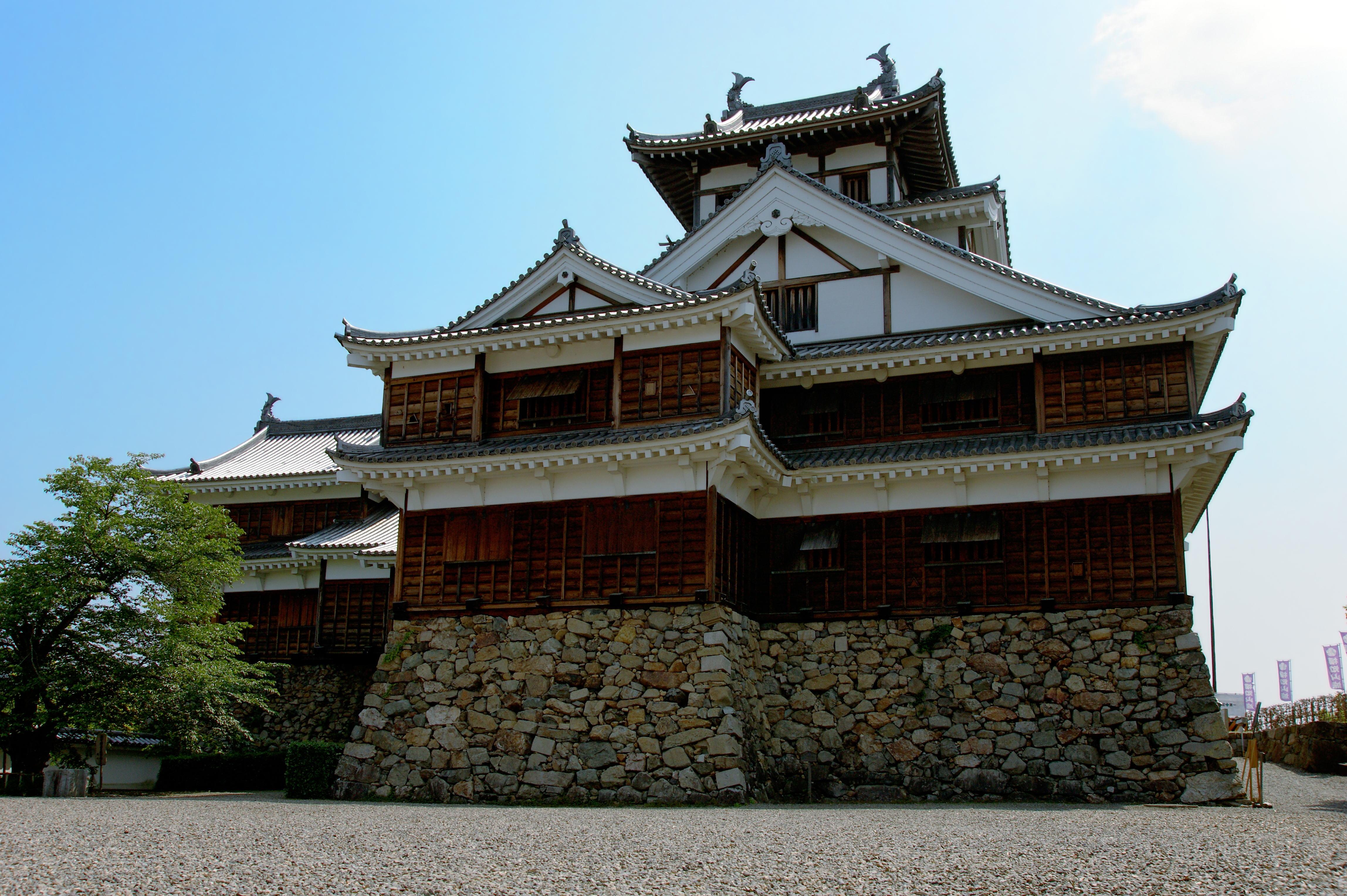
- Fukuchiyama Castle
Sports
Fukuchiyama is the birthplace of tambo rugby.
Noted people from Fukuchiyama
- Osamu Shimomura, a Nobel Prize–winning chemist
- Kenta Kobashi, a professional wrestling icon
- Sadakazu Tanigaki, Secretary-General of the LDP
References
- "Fukuchiyama city official statistics" (in Japanese). Japan.
- 気象庁 / 平年値(年・月ごとの値). JMA. Retrieved March 28, 2022.
- 観測史上1~10位の値(年間を通じての値). JMA. Retrieved March 28, 2022.
- Fukuchiyama population statistics
External links
![]() Media related to Fukuchiyama, Kyoto at Wikimedia Commons
Media related to Fukuchiyama, Kyoto at Wikimedia Commons
Authority control | |
|---|---|
| General | |
| National libraries | |
| Other |
|
This Kyoto Prefecture location article is a stub. You can help Wikipedia by expanding it. |
На других языках
[de] Fukuchiyama
Fukuchiyama (japanisch 福知山市, -shi) ist eine japanische Stadt im Norden der Präfektur Kyōto.- [en] Fukuchiyama, Kyoto
[es] Fukuchiyama (Kioto)
Fukuchiyama (福知山市, Fukuchiyama-shi?) es una ciudad localizada en la prefectura de Kioto, Japón. En junio de 2019 tenía una población de 76.827 habitantes y una densidad de población de 139 personas por km². Su área total es de 552,54 km².[ru] Фукутияма
Фукутия́ма (яп. 福知山市 Фукутияма-си) — город в Японии, находящийся в префектуре Киото. Площадь города составляет 552,54 км²[1], население — 77 349 человек (1 октября 2020)[2], плотность населения — 139,99 чел./км².Другой контент может иметь иную лицензию. Перед использованием материалов сайта WikiSort.org внимательно изучите правила лицензирования конкретных элементов наполнения сайта.
WikiSort.org - проект по пересортировке и дополнению контента Википедии