world.wikisort.org - Japan
Daisen (大山町, Daisen-chō) is a town located in Saihaku District, Tottori Prefecture, Japan. As of June 1, 2016, Daisen had an estimated population of 16,357 and a population density of 86.2 persons per km². The total area is 189.79 square kilometres (73.28 sq mi). The town is known for Mount Daisen, the tallest mountain in the Chūgoku Region. The mountain was an early center of Shinto and Buddhist practice, and the town has numerous designated Cultural Properties of Japan.[1]
Daisen
大山町 | |
|---|---|
Town | |
 Daisen Temple | |
 Flag | |
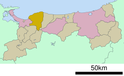 Location of Daisen in Tottori Prefecture | |
 Daisen Location in Japan | |
| Coordinates: 35°30′N 133°30′E | |
| Country | Japan |
| Region | Chūgoku San'in |
| Prefecture | Tottori Prefecture |
| District | Saihaku |
| Government | |
| • Mayor | Takayuki Yamaguchi (since April 2005) |
| Area | |
| • Total | 189.83 km2 (73.29 sq mi) |
| Population (June 1, 2016) | |
| • Total | 16,357 |
| • Density | 86.2/km2 (223/sq mi) |
| Time zone | UTC+09:00 (JST) |
| City hall address | 328 Mikushiya, Daisen, Saihaku-gun, Tottori-ken 689-3211 |
| Climate | Cfa |
| Website | www |
| Symbols | |
| Flower | Camellia sasanqua |
| Tree | Taxus cuspidata |
Geography
Daisen is located to the west of Saihaku District. The north of the town has a broad coast along the Japan Sea, and its inland area sweeps up to the Chūgoku Region, specifically Mount Daisen. The Amida River flows north towards the Sea of Japan and forms an alluvial delta in Daisen.[1]
Climate
Chizu has a Humid climate (Köppen Cfa) characterized by warm, wet summers and cold winters with heavy snowfall. The average annual temperature in Chizu is 15.0 °C (59.0 °F). The average annual rainfall is 1,801.6 mm (70.93 in) with September as the wettest month. The temperatures are highest on average in August, at around 26.3 °C (79.3 °F), and lowest in January, at around 5.0 °C (41.0 °F).[2] Its record high is 37.2 °C (99.0 °F), reached on 22 August 2018, and its record low is −7.6 °C (18.3 °F), reached on 26 February 2011.[3]
| Climate data for Daisen (1991−2020 normals, extremes 1977−present) | |||||||||||||
|---|---|---|---|---|---|---|---|---|---|---|---|---|---|
| Month | Jan | Feb | Mar | Apr | May | Jun | Jul | Aug | Sep | Oct | Nov | Dec | Year |
| Record high °C (°F) | 20.6 (69.1) |
23.9 (75.0) |
26.6 (79.9) |
31.0 (87.8) |
31.4 (88.5) |
34.6 (94.3) |
35.7 (96.3) |
37.2 (99.0) |
36.5 (97.7) |
32.7 (90.9) |
27.7 (81.9) |
24.6 (76.3) |
37.2 (99.0) |
| Average high °C (°F) | 8.2 (46.8) |
8.9 (48.0) |
12.1 (53.8) |
17.0 (62.6) |
21.5 (70.7) |
24.4 (75.9) |
28.5 (83.3) |
30.1 (86.2) |
26.2 (79.2) |
21.4 (70.5) |
16.4 (61.5) |
11.0 (51.8) |
18.8 (65.9) |
| Daily mean °C (°F) | 5.0 (41.0) |
5.4 (41.7) |
8.0 (46.4) |
12.6 (54.7) |
17.1 (62.8) |
20.8 (69.4) |
25.1 (77.2) |
26.3 (79.3) |
22.6 (72.7) |
17.5 (63.5) |
12.5 (54.5) |
7.5 (45.5) |
15.0 (59.1) |
| Average low °C (°F) | 2.0 (35.6) |
1.8 (35.2) |
3.7 (38.7) |
7.8 (46.0) |
12.5 (54.5) |
17.4 (63.3) |
22.1 (71.8) |
22.9 (73.2) |
19.1 (66.4) |
13.6 (56.5) |
8.6 (47.5) |
4.2 (39.6) |
11.3 (52.4) |
| Record low °C (°F) | −6.3 (20.7) |
−7.6 (18.3) |
−3.2 (26.2) |
−0.9 (30.4) |
3.3 (37.9) |
8.6 (47.5) |
12.9 (55.2) |
15.5 (59.9) |
8.3 (46.9) |
4.7 (40.5) |
0.9 (33.6) |
−3.6 (25.5) |
−7.6 (18.3) |
| Average precipitation mm (inches) | 160.8 (6.33) |
113.8 (4.48) |
123.3 (4.85) |
100.2 (3.94) |
111.3 (4.38) |
157.1 (6.19) |
207.8 (8.18) |
143.0 (5.63) |
230.4 (9.07) |
136.4 (5.37) |
141.0 (5.55) |
176.6 (6.95) |
1,801.6 (70.93) |
| Average precipitation days (≥ 1.0 mm) | 18.7 | 14.4 | 13.7 | 10.1 | 9.5 | 10.6 | 12.0 | 10.0 | 12.1 | 10.9 | 13.6 | 18.0 | 153.6 |
| Mean monthly sunshine hours | 71.0 | 89.1 | 148.0 | 189.2 | 205.5 | 160.8 | 177.9 | 214.9 | 149.9 | 152.5 | 110.3 | 78.6 | 1,747.7 |
| Source: Japan Meteorological Agency[3][2] | |||||||||||||
History
The town of Daisen was formed from the merger of the towns of Nakayama and Nawa, both from Saihaku District, on March 28, 2005.
Sister city
The town is a sister city to Temecula, California.
References
- "大山町 (Daisen-chō)". Nihon Daihyakka Zensho (Nipponika) (日本大百科全書(ニッポニカ) (in Japanese). Tokyo: Shogakukan. 2012. Archived from the original on August 25, 2007. Retrieved 2012-04-27.
- 気象庁 / 平年値(年・月ごとの値). JMA. Retrieved March 24, 2022.
- 観測史上1~10位の値(年間を通じての値). JMA. Retrieved March 24, 2022.
External links
 Daisen (Tottori) travel guide from Wikivoyage
- Official website (in Japanese)
- Daisen guide
Tottori (capital) | ||
| Core city |
|  |
| Cities |
| |
| Districts | ||
List of mergers in Tottori Prefecture | ||
This Tottori location article is a stub. You can help Wikipedia by expanding it. |
На других языках
- [en] Daisen, Tottori
[ru] Дайсен (посёлок)
Дайсен (яп. 大山町 Дайсэн-тё:) — посёлок в Японии, находящийся в уезде Сайхаку префектуры Тоттори. Площадь посёлка составляет 189,79 км²[1], население — 16 547 человек (1 августа 2014)[2], плотность населения — 87,19 чел./км².Другой контент может иметь иную лицензию. Перед использованием материалов сайта WikiSort.org внимательно изучите правила лицензирования конкретных элементов наполнения сайта.
WikiSort.org - проект по пересортировке и дополнению контента Википедии