world.wikisort.org - Japan
Iwami (岩美町, Iwami-chō) is a town located in Iwami District, Tottori Prefecture, Japan.
Iwami
岩美町 | |
|---|---|
Town | |
 Iwami Town Office | |
 Flag | |
 Location of Iwami in Tottori Prefecture | |
 Iwami Location in Japan | |
| Coordinates: 35°35′N 134°20′E | |
| Country | Japan |
| Region | Chūgoku San'in |
| Prefecture | Tottori Prefecture |
| District | Iwami |
| Area | |
| • Total | 122.32 km2 (47.23 sq mi) |
| Population (June 1, 2016) | |
| • Total | 11,382 |
| • Density | 93.1/km2 (241/sq mi) |
| Time zone | UTC+09:00 (JST) |
| City hall address | 675-1 Uradome, Iwami-chō, Tottori-ken 681-8501 |
| Climate | Cfa |
| Website | www |
| Symbols | |
| Flower | Iris |
| Tree | Pine |
Iwami lies entirely within the San'in Kaigan Geopark.[1]
Geography
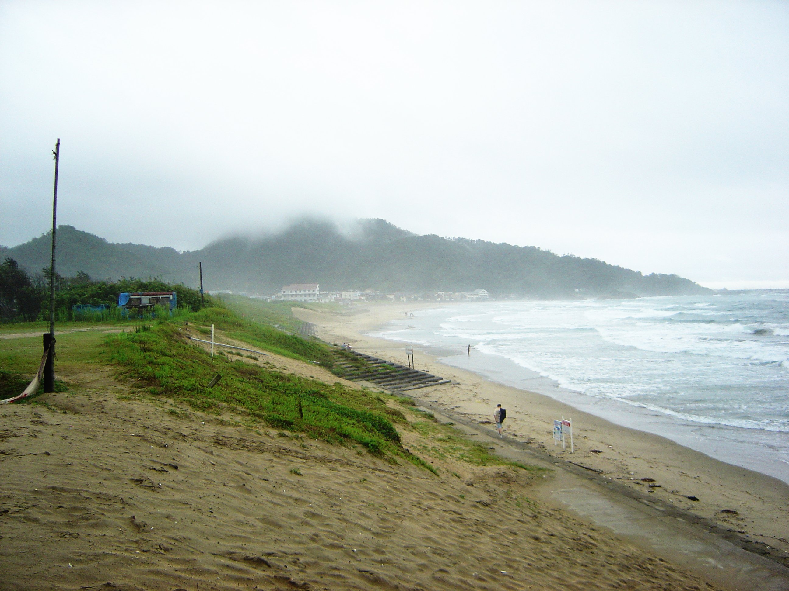
Located in eastern Tottori, Iwami faces the Sea of Japan to the north. As of June 1, 2016, the town has an estimated population of 11,382 and a density of 93 persons per km². The total area is 122.32 km². The surrounding landscape is dominated by low-lying hills and slopes; much of the built town and residential areas are located in flatter land between the heights. The north of the town borders onto Uradome Beach, though much of the rest of the coast consists of rough rocky outcrops and small inlets and bays. 15 km of this, collectively known as the Uradome Coast, is part of the Sanin Kaigan National Park.[2] The Gamō River runs through the centre of the town. Iwami is around 30 minutes by train from the prefectural capital of Tottori City, and is the third stop by train heading east on the Tottori-Hamasaka line. Hyōgo Prefecture and Iwami's sister town of Shin'onsen are relatively nearby as well.
Weather in Iwami can be quite changeable, with summer temperatures peaking at over 30 degrees Celsius in August and dropping as low as -2 degrees in January and February. Whilst relatively tectonically stable for Japan, the area is prone to the occasional typhoon during the season.
Neighbouring municipalities
- Tottori Prefecture
- Tottori
- Hyogo Prefecture
- Shin'onsen
Climate
Iwami has a Humid climate (Köppen Cfa) characterized by warm, wet summers and cold winters with heavy snowfall. The average annual temperature in Iwami is 14.2 °C (57.6 °F). The average annual rainfall is 2,197.5 mm (86.52 in) with December as the wettest month. The temperatures are highest on average in August, at around 25.8 °C (78.4 °F), and lowest in January, at around 3.7 °C (38.7 °F).[3] Its record high is 37.6 °C (99.7 °F), reached on 22 August 2018, and its record low is −8.5 °C (16.7 °F), reached on 9 February 2018.[4]
| Climate data for Iwami (1991−2020 normals, extremes 1978−present) | |||||||||||||
|---|---|---|---|---|---|---|---|---|---|---|---|---|---|
| Month | Jan | Feb | Mar | Apr | May | Jun | Jul | Aug | Sep | Oct | Nov | Dec | Year |
| Record high °C (°F) | 19.5 (67.1) |
22.4 (72.3) |
25.1 (77.2) |
31.5 (88.7) |
31.4 (88.5) |
34.3 (93.7) |
37.1 (98.8) |
37.6 (99.7) |
36.1 (97.0) |
32.7 (90.9) |
26.5 (79.7) |
23.1 (73.6) |
37.6 (99.7) |
| Average high °C (°F) | 7.6 (45.7) |
8.4 (47.1) |
12.3 (54.1) |
18.1 (64.6) |
22.9 (73.2) |
25.7 (78.3) |
29.5 (85.1) |
31.0 (87.8) |
26.8 (80.2) |
21.7 (71.1) |
16.4 (61.5) |
10.6 (51.1) |
19.3 (66.7) |
| Daily mean °C (°F) | 3.7 (38.7) |
4.0 (39.2) |
6.9 (44.4) |
12.0 (53.6) |
16.9 (62.4) |
20.8 (69.4) |
24.9 (76.8) |
25.8 (78.4) |
21.8 (71.2) |
16.3 (61.3) |
11.2 (52.2) |
6.2 (43.2) |
14.2 (57.6) |
| Average low °C (°F) | 0.3 (32.5) |
0.0 (32.0) |
1.7 (35.1) |
5.9 (42.6) |
11.1 (52.0) |
16.5 (61.7) |
21.1 (70.0) |
21.7 (71.1) |
17.8 (64.0) |
11.8 (53.2) |
6.7 (44.1) |
2.3 (36.1) |
9.7 (49.5) |
| Record low °C (°F) | −6.4 (20.5) |
−8.5 (16.7) |
−5.5 (22.1) |
−2.4 (27.7) |
2.2 (36.0) |
6.6 (43.9) |
11.4 (52.5) |
14.5 (58.1) |
7.9 (46.2) |
2.3 (36.1) |
−0.2 (31.6) |
−6.8 (19.8) |
−8.5 (16.7) |
| Average precipitation mm (inches) | 225.1 (8.86) |
153.5 (6.04) |
149.9 (5.90) |
114.4 (4.50) |
136.8 (5.39) |
161.2 (6.35) |
202.3 (7.96) |
137.9 (5.43) |
265.4 (10.45) |
186.3 (7.33) |
199.8 (7.87) |
271.4 (10.69) |
2,197.5 (86.52) |
| Average precipitation days (≥ 1.0 mm) | 21.9 | 16.4 | 14.5 | 11.3 | 10.7 | 11.3 | 12.6 | 10.2 | 13.3 | 12.1 | 15.9 | 20.6 | 170.8 |
| Mean monthly sunshine hours | 54.8 | 76.4 | 132.5 | 182.2 | 205.0 | 153.6 | 168.7 | 207.9 | 139.6 | 142.8 | 100.3 | 66.9 | 1,627.7 |
| Source: Japan Meteorological Agency[4][3] | |||||||||||||
Education
There are three elementary schools - Iwami Minami, Nishi, and Kita - as well as a junior high school and a high school. In July 2005 the Iwami High School baseball team progressed to the semi-finals in the prefecture-wide high schools' baseball tournament. This was the furthest the team had ever progressed and was an event of prefecture-wide significance. They lost in the semi-finals to Tottori Nishi High School.[citation needed]
Economy
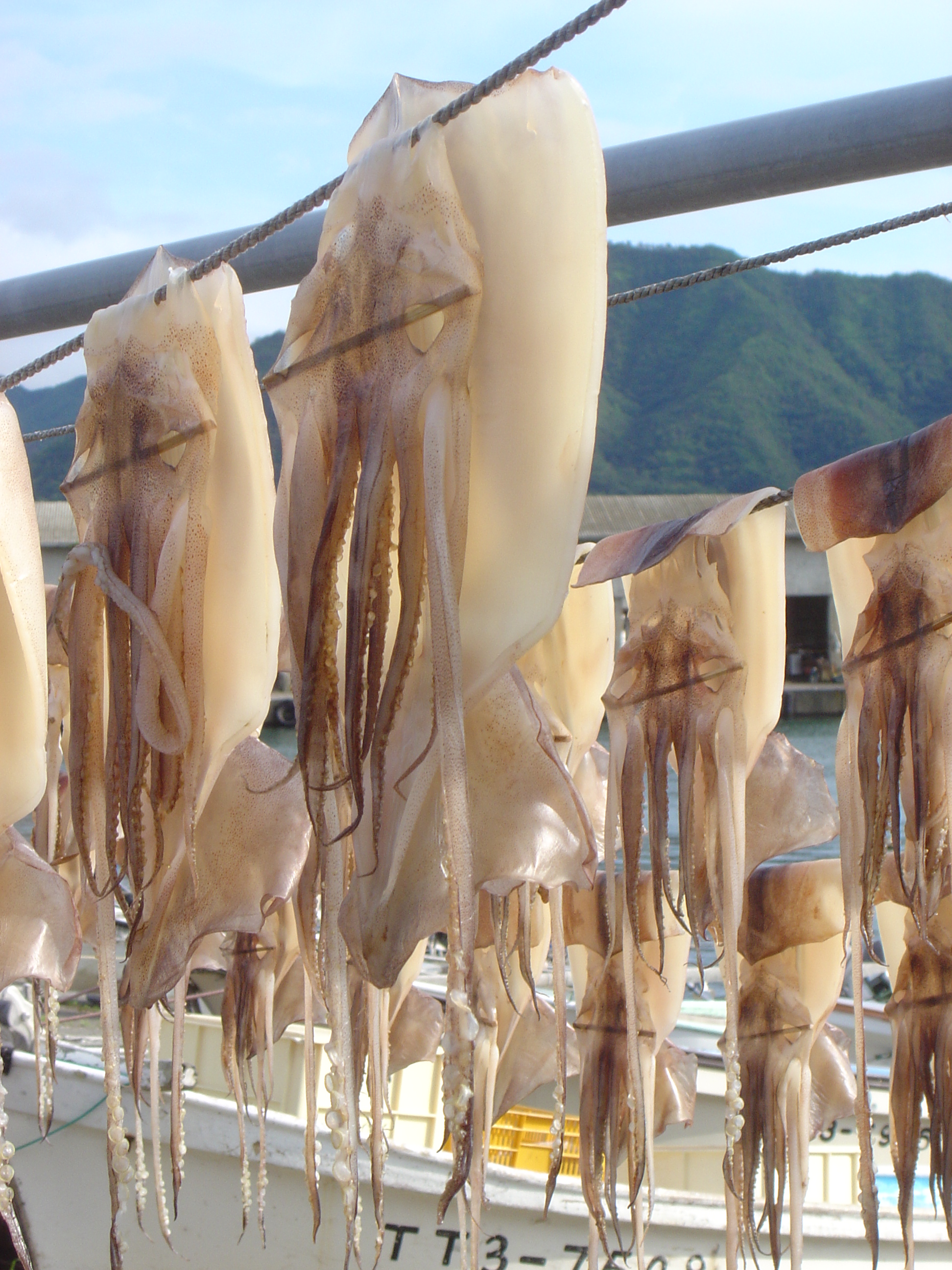
The majority of the town's working population works on squid fishing boats or farm, the most common crop being rice. Iwami also has a locally renowned onsen (hot spring), the Iwai onsen.
Iwami also features several restaurants which provide seafood-based meals and okonomiyaki, as well as a Family Mart and a Suntopia.
Culture
Iwami served as the model for the fictional town of Iwatobi, the setting for the anime series Free!. Iwami has used the series to promote tourism to the town.[5][6]
Transportation
Railway
 JR West - San'in Main Line
- Higashihama - Iwami - Ōiwa
References
- "What is San'in Kaigan Geopark" on the official website of San'in Kaigan Geopark (in Japanese)
- "鳥取県岩美町:岩美町の紹介". Archived from the original on 2008-03-29. Retrieved 2008-03-30.
- 気象庁 / 平年値(年・月ごとの値). JMA. Retrieved March 25, 2022.
- 観測史上1~10位の値(年間を通じての値). JMA. Retrieved March 25, 2022.
- Dong, Bamboo (October 15, 2013). "Town of Iwami Offers Exclusive Free! Merchandise and Iwatobi-chan Scarecrow". Anime News Network. Retrieved November 13, 2015.
- Stimson, Eric (November 13, 2015). "Seaside Town of Iwami Celebrates Upcoming Free! Prequel". Anime News Network. Retrieved November 12, 2015.
External links
 Media related to Iwami, Tottori at Wikimedia Commons
- Iwami official website (in English)
Tottori (capital) | ||
| Core city |
|  |
| Cities |
| |
| Districts | ||
List of mergers in Tottori Prefecture | ||
На других языках
- [en] Iwami, Tottori
[ru] Ивами (посёлок)
Ивами (яп. 岩美町 Ивами-тё:) — посёлок в Японии, находящийся в уезде Ивами префектуры Тоттори. Площадь посёлка составляет 122,38 км²[1], население — 11 713 человек (1 августа 2014)[2], плотность населения — 95,71 чел./км².Другой контент может иметь иную лицензию. Перед использованием материалов сайта WikiSort.org внимательно изучите правила лицензирования конкретных элементов наполнения сайта.
WikiSort.org - проект по пересортировке и дополнению контента Википедии