world.wikisort.org - Japan
Sakaiminato (境港市, Sakaiminato-shi) is a city in Tottori Prefecture, Japan.[1] In 2016, it had an estimated population of 33,888.
This article needs additional citations for verification. (January 2009) |
Sakaiminato
境港市 | |
|---|---|
City | |
 Downtown Sakaiminato, near Sakaiminato Station | |
 Flag  Seal | |
 Location of Sakaiminato in Tottori Prefecture | |
 Sakaiminato Location in Japan | |
| Coordinates: 35°32′N 133°14′E | |
| Country | Japan |
| Region | Chūgoku (San'in) |
| Prefecture | Tottori Prefecture |
| Government | |
| • Mayor | Kentarō Date |
| Area | |
| • Total | 29.02 km2 (11.20 sq mi) |
| Population (1 June 2016) | |
| • Total | 33,888 |
| • Density | 1,200/km2 (3,000/sq mi) |
| Time zone | UTC+09:00 (JST) |
| City hall address | 3000, Agarimichichō, Sakaiminato-shi, Tottori-ken 684-8501 |
| Climate | Cfa |
| Website | www |
| Symbols | |
| Flower | Chrysanthemum |
| Tree | Japanese Black Pine |
History
An Imperial decree in July 1899 established Sakai as an open port for trading with the United States and the United Kingdom.[2]
Sakaiminato was founded on April 1, 1956. A merger with Yonago and other neighboring municipalities was proposed, but the majority of the citizens voted against this, and Sakaiminato remained an autonomous municipality.[citation needed]
Sakaiminato was the only Japanese municipality to have a twin town agreement with a North Korean city from 1992 to 2006. In 2006, Mayor Katsuji Nakamura revoke the agreement in response to North Korea's announcement of a nuclear test along with the Japanese government's decision to impose economic sanctions. Actual twin town activities had already come to an end by 2002, after which the cities had only sent each other a letter once per year.[3]
Geography

At the northern end of Yumigahama Peninsula, it is surrounded by the Miho Bay on the Sea of Japan to the east, Lake Nakaumi to the west and the Sakai Channel in the north, which also makes up the border with Shimane Prefecture and its capital Matsue. [citation needed]
In 2008, Sakaiminato had an estimated population of 35,710 and a population density of 1,240 persons per km2. The total area is 28.79 km2 (11.12 sq mi).[citation needed]
Climate
Sakaiminato has a Humid climate (Köppen Cfa) characterized by warm, wet summers and cold winters with heavy snowfall. The average annual temperature in Sakaiminato is 15.5 °C (59.9 °F). The average annual rainfall is 1,903.3 mm (74.93 in) with July as the wettest month. The temperatures are highest on average in August, at around 27.3 °C (81.1 °F), and lowest in January, at around 4.9 °C (40.8 °F).[4] Its record high is 38.5 °C (101.3 °F), reached on 22 August 2018, and its record low is −9.7 °C (14.5 °F), reached on 27 January 1904.[5]
| Climate data for Sakaiminato (1991−2020 normals, extremes 1883−present) | |||||||||||||
|---|---|---|---|---|---|---|---|---|---|---|---|---|---|
| Month | Jan | Feb | Mar | Apr | May | Jun | Jul | Aug | Sep | Oct | Nov | Dec | Year |
| Record high °C (°F) | 19.7 (67.5) |
24.6 (76.3) |
26.7 (80.1) |
31.2 (88.2) |
32.9 (91.2) |
35.0 (95.0) |
37.5 (99.5) |
38.5 (101.3) |
36.9 (98.4) |
33.6 (92.5) |
27.7 (81.9) |
22.3 (72.1) |
38.5 (101.3) |
| Average high °C (°F) | 8.3 (46.9) |
9.2 (48.6) |
12.8 (55.0) |
18.4 (65.1) |
23.1 (73.6) |
26.0 (78.8) |
29.9 (85.8) |
31.5 (88.7) |
27.0 (80.6) |
22.1 (71.8) |
16.7 (62.1) |
11.0 (51.8) |
19.7 (67.4) |
| Daily mean °C (°F) | 4.9 (40.8) |
5.3 (41.5) |
8.3 (46.9) |
13.3 (55.9) |
18.1 (64.6) |
21.8 (71.2) |
25.9 (78.6) |
27.3 (81.1) |
23.2 (73.8) |
17.8 (64.0) |
12.4 (54.3) |
7.3 (45.1) |
15.5 (59.8) |
| Average low °C (°F) | 1.7 (35.1) |
1.6 (34.9) |
3.9 (39.0) |
8.4 (47.1) |
13.6 (56.5) |
18.4 (65.1) |
22.9 (73.2) |
24.1 (75.4) |
20.0 (68.0) |
13.8 (56.8) |
8.4 (47.1) |
3.9 (39.0) |
11.7 (53.1) |
| Record low °C (°F) | −9.7 (14.5) |
−8.2 (17.2) |
−5.6 (21.9) |
−2.1 (28.2) |
1.8 (35.2) |
7.0 (44.6) |
12.0 (53.6) |
14.5 (58.1) |
8.3 (46.9) |
2.3 (36.1) |
−1.4 (29.5) |
−7.9 (17.8) |
−9.7 (14.5) |
| Average precipitation mm (inches) | 188.4 (7.42) |
136.0 (5.35) |
139.7 (5.50) |
111.2 (4.38) |
123.3 (4.85) |
170.8 (6.72) |
215.2 (8.47) |
140.9 (5.55) |
212.8 (8.38) |
133.5 (5.26) |
145.9 (5.74) |
193.2 (7.61) |
1,903.3 (74.93) |
| Average snowfall cm (inches) | 32 (13) |
25 (9.8) |
6 (2.4) |
0 (0) |
0 (0) |
0 (0) |
0 (0) |
0 (0) |
0 (0) |
0 (0) |
0 (0) |
14 (5.5) |
75 (30) |
| Average precipitation days (≥ 1.0 mm) | 19.6 | 15.0 | 13.2 | 10.4 | 9.1 | 9.9 | 11.0 | 9.4 | 10.8 | 10.1 | 13.0 | 18.5 | 150 |
| Average snowy days (≥ 1 cm) | 7.1 | 5.8 | 1.1 | 0 | 0 | 0 | 0 | 0 | 0 | 0 | 0 | 3.4 | 17.4 |
| Average relative humidity (%) | 74 | 72 | 69 | 68 | 70 | 77 | 79 | 76 | 77 | 74 | 73 | 74 | 74 |
| Mean monthly sunshine hours | 63.0 | 81.8 | 137.9 | 183.9 | 208.9 | 162.0 | 174.3 | 207.1 | 147.5 | 154.8 | 109.2 | 74.7 | 1,705.1 |
| Source: Japan Meteorological Agency[5][4] | |||||||||||||
Economy

The seaport of Sakaiminato has a long history as a seaport for the San'in Region. Following World War II the city has served as the base of the fishing industry for all of Western Japan. Consequently, marine product processing is also a major industry in the city.[6]
Administration
The current Mayor of Sakaiminato is Kentarō Date, serving since July 25, 2020.
Mayors
- Minoru Adachi (September 5, 1954 -)
- Seiichirō Kashiwagi (September 5, 1966 -)
- Sadae Yasuda (September 5, 1978 - November 20, 1989)
- Tetsuo Kuromi (December 10, 1989 - June 5, 2004)
- Katsuji Nakamura (July 25, 2004 - July 24, 2020)[7]
- Kentarō Date (July 25, 2020 -)
City Council
The Sakaiminato City Council meets four times a year (March, June, September, and December) and special meetings take place if required. The mayor convenes the city council meetings, but the mayor must call a special meeting when requested by one-fourth or more of the fixed number of council members . The City Council members are citizens who are at least 25 years of age, and are elected every four years. In Sakaiminato City, the number of council members is set at 15 by ordinance.[8]
Chairman and Vice Chairman of the City Council
- Chairman: Hideyuki Arai (February 25, 2022 -)
- Vice Chairman: Shunsuke Taguchi (February 25, 2022 -)[9]
Transportation
Yonago Airport is in Sakaiminato and is the busiest airport in Tottori Prefecture.[6] Nearby Miho Airbase, next to the airport, is run by the Ministry of Defence. Asiana Airlines operates a sales office in Sakaiminato.[10]
Sakaiminato is linked to the Japanese railway network by the Sakai Line branch, which runs between Sakaiminato Station and Yonago Station on the San'in Main Line.[11]
The port at Sakaiminato serves the DBS Cruise ferry Eastern Dream, which connects Japan to Donghae, South Korea, and Vladivostok, Russia.[12]
Twin towns – sister cities
Sakaiminato is twinned with:
Former twin towns
 Wonsan, North Korea (revoked in 2006)[3]
Notable residents
Sakaiminato is the home of Shigeru Mizuki, the creator of GeGeGe no Kitaro, a character seen in many forms throughout Japan. The spirit of Kitaro can be found in Sakaiminato, on Kitaro Road, a street dedicated to all the characters that appear in Mizuki's stories. One hundred bronze statues of the story's characters line both sides of the road.[citation needed]
Sakaiminato was also where the photographer Shōji Ueda was born and ran a studio.[citation needed]
Gallery
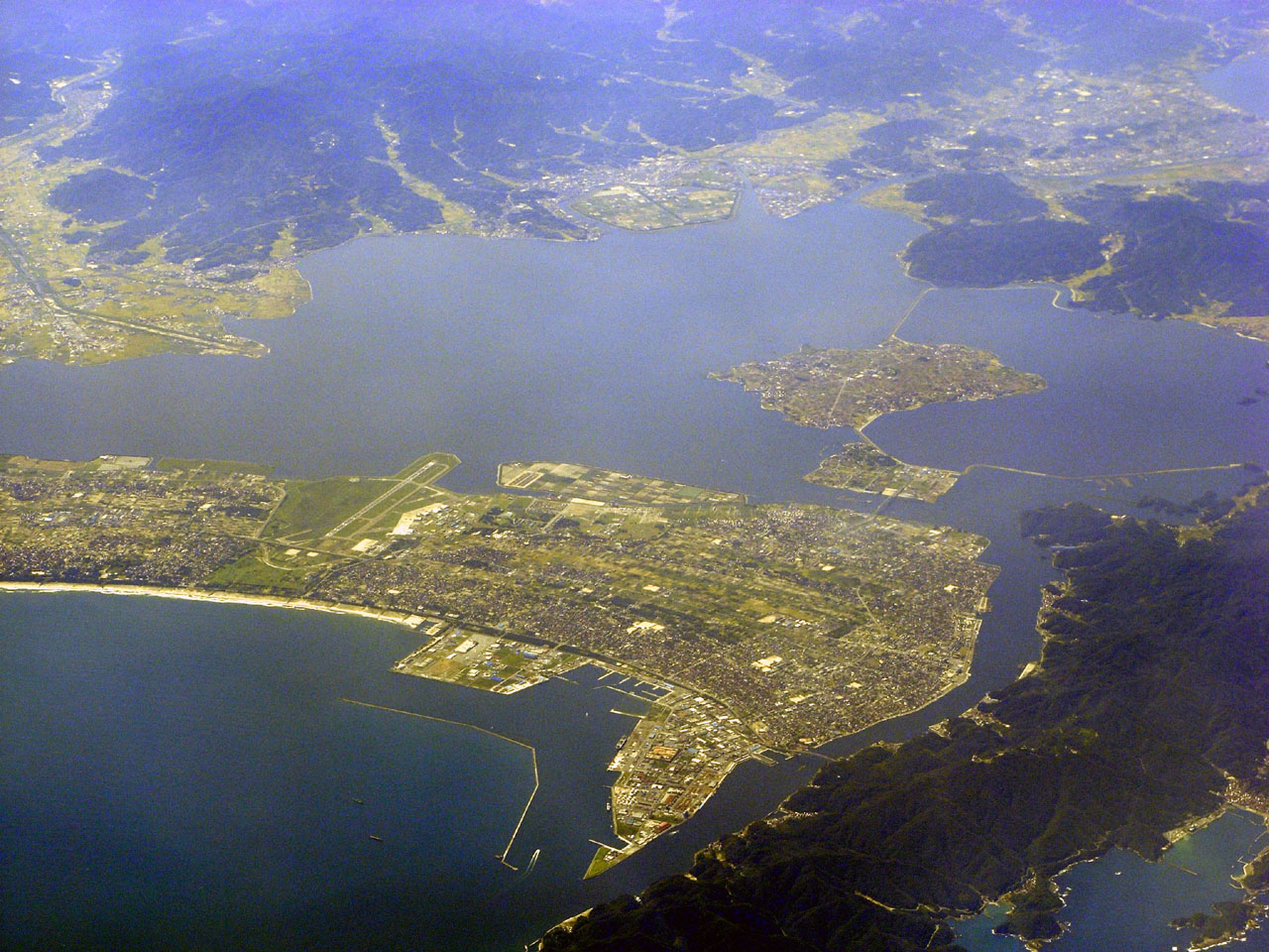
 Aerial view of part of Sakaiminato.
 Eshima Ohashi Bridge links Sakaiminato and Matsue across a narrow channel.

References
- The name of Sakaiminato in the Japanese language is formed from two kanji characters. The first, 境, means "border", and the second, 港 means "port".
- US Department of State. (1906). A digest of international law as embodied in diplomatic discussions, treaties and other international agreements (John Bassett Moore, ed.), Vol. 5, p. 759.
- "境港市 北核実験の影響じわり 元山市との提携破棄". Mindan Shimbun. Retrieved 2022-03-10.
- 気象庁 / 平年値(年・月ごとの値). JMA. Retrieved March 24, 2022.
- 観測史上1~10位の値(年間を通じての値). JMA. Retrieved March 24, 2022.
- "Kurayoshi Plain". Encyclopedia of Japan. Tokyo: Shogakukan. 2012. Archived from the original on 2007-08-25. Retrieved 2012-04-12.
- Sakaiminato City 55th Anniversary History 境港市五十五周年史. Sakaiminato City 境港市. 2013. p. 138.
- "市議会のしくみ:さかなと鬼太郎のまち境港市 Sakaiminato City Council". Sakaiminato City. Retrieved 2022-03-10.
- "議会構成:さかなと鬼太郎のまち境港市 Sakaiminato City Council". Sakaiminato City. Retrieved 2022-03-10.
- "Worldwide Offices Japan." Asiana Airlines. Retrieved on 2009-01-19 from http://us.flyasiana.com/Global/US/en/homepage?cmd=&fid=ABOUT13000®ion=JP&city=&searchWrd=#01.
- "Sakaiminato/Yonago". Japan: The Official Guide. Japan National Tourism Organization. Retrieved 2015-06-24.
- "DBS Cruise Ferry Sakaiminato - Donghae - Vladivostok". DBS Cruise Ferry. Retrieved 2015-06-24.
- "境港市の友好都市". city.sakaiminato.lg.jp (in Japanese). Sakaiminato. Retrieved 2020-11-12.
External links
 Media related to Sakaiminato, Tottori at Wikimedia Commons
- Sakaiminato City official web site (in Japanese)
- Sakaiminato City official web site (in English)
Tottori (capital) | ||
| Core city |
|  |
| Cities |
| |
| Districts | ||
List of mergers in Tottori Prefecture | ||
Authority control | |
|---|---|
| General | |
| National libraries | |
| Scientific databases | |
| Other |
|
На других языках
[de] Sakaiminato
Sakaiminato (jap. .mw-parser-output .Hani{font-size:110%}境港市, -shi) ist eine Stadt in der Präfektur Tottori in Japan.- [en] Sakaiminato, Tottori
[es] Sakaiminato (Tottori)
Sakaiminato (境港市, Sakaiminato-shi?) es una ciudad localizada en la prefectura de Tottori, Japón. En junio de 2019 tenía una población estimada de 32.922 habitantes y una densidad de población de 1.131 personas por km². Su área total es de 29,10 km².[ru] Сакаиминато
Сакаиминато (яп. 境港市 Сакаиминато-си) — город в Японии, находящийся в префектуре Тоттори. Площадь города составляет 28,79 км²[1], население — 34 445 человек (1 августа 2014)[2], плотность населения — 1196,42 чел./км².Другой контент может иметь иную лицензию. Перед использованием материалов сайта WikiSort.org внимательно изучите правила лицензирования конкретных элементов наполнения сайта.
WikiSort.org - проект по пересортировке и дополнению контента Википедии