world.wikisort.org - India
Vellore district (Tamil: [ʋeːluːɾ]) is one of the 38 districts in the Tamil Nadu state of India. It is one of the eleven districts that form the north region of Tamil Nadu. Vellore city is the headquarters of this district. As of 2011, the district had a population of 1,614,242 with a sex ratio of 1,007 females for every 1,000 males. In 2017 Vellore district ranked eleventh in list of districts in Tamil Nadu by Human Development Index.[4][5]
This article needs additional citations for verification. (February 2019) |
Vellore district | |
|---|---|
District of Tamil Nadu | |
 Palar river near Vellore | |
| Nickname: Fort City | |
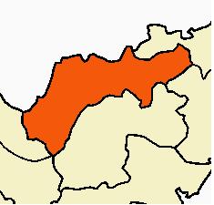
 Vellore district Location in Tamil Nadu | |
| Coordinates: 12°54′40″N 79°8′10″E | |
| Country | |
| State | |
| Region | Vellore |
| Established | 1996 |
| Headquarters | Vellore |
| Talukas | Vellore, Anaicut, Katpadi, Gudiyatham, Pernambut, K.V Kuppam[1] |
| Government | |
| • Collector & District Magistrate | P. Kumaravel Pandian IAS |
| • Superintendent of Police | S. Rajesh Kannan IPS |
| • District Forest Officer | R. Murugan IFS |
| Area | |
| • Total | 2,030.11 km2 (783.83 sq mi) |
| Population | |
| • Total | 1,614,242 |
| • Density | 800/km2 (2,100/sq mi) |
| Languages | |
| • Official | Tamil |
| Time zone | UTC+5:30 (IST) |
| Telephone code | 0416 |
| Vehicle registration | 'TN-23 |
| Coastline | 0 kilometres (0 mi) |
| Largest city | Vellore |
| Sex ratio | M-50.06%/F-49.94% ♂/♀ |
| Literacy | 79.65% |
| Legislature type | elected |
| Legislature Strength | 5 |
| Lok Sabha constituency | Vellore |
| Precipitation | 917 millimetres (36.1 in) |
| Avg. summer temperature | 39.5 °C (103.1 °F) |
| Avg. winter temperature | 15.6 °C (60.1 °F) |
| Website | District |
The Government of India recently included Vellore city in its prestigious smart city project, along with 26 other cities.[6]
History

Men from the Vellore District fought in the British India Army and sacrificed their lives in the World Wars. This is recorded in the clock tower in the long bazaar at Vellore, raised in 1920, where an inscription reads "Vellore – From this Village 277 men went to the Great war 1914–18, of them 14 gave up their lives".[7]
On 30 September 1989 the district was again split into Tiruvannamalai-Sambuvarayar (present-day Tiruvannamalai) and North Arcot Ambedkar districts.[citation needed] North Arcot Ambedkar District was renamed Vellore District in 1996.[8][9]
On 15 August 2019, the district was trifurcated into Vellore, Tirupattur and Ranipet districts.
Demographics
| Year | Pop. | ±% p.a. |
|---|---|---|
| 1901 | 967,845 | — |
| 1911 | 1,057,841 | +0.89% |
| 1921 | 1,088,264 | +0.28% |
| 1931 | 1,228,535 | +1.22% |
| 1941 | 1,440,228 | +1.60% |
| 1951 | 1,676,438 | +1.53% |
| 1961 | 1,817,967 | +0.81% |
| 1971 | 2,231,448 | +2.07% |
| 1981 | 2,628,526 | +1.65% |
| 1991 | 3,026,432 | +1.42% |
| 2001 | 3,477,317 | +1.40% |
| 2011 | 3,936,331 | +1.25% |
| 2011 (after trifurcation) | 1,614,242 | −100.00% |
| source:[10] | ||
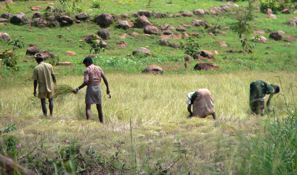
According to 2011 census, Vellore district had a population of 1,614,242 with a sex ratio of 1,007 females for every 1,000 males, much above the national average of 929.[2][11] A total of 432,550 were under the age of six, constituting 222,460 males and 210,090 females. Scheduled Castes and Scheduled Tribes accounted for 21.85% and 1.85% of the population, respectively. The average literacy of the district was 70.47%, compared to the national average of 72.99%.[11]
The district had 929,281 households. There were 1,689,330 workers, comprising 153,211 cultivators, 254,999 main agricultural labourers, 106,906 in household industries, 845,069 other workers, 329,145 marginal workers, 21,897 marginal cultivators, 136,956 marginal agricultural labourers, 29,509 marginal workers in household industries and 140,783 other marginal workers.[12]
Politics
| District | No. | Constituency | Name | Party | Alliance | Remarks | ||
|---|---|---|---|---|---|---|---|---|
| Vellore district | 40 | Katpadi | Durai Murugan | Dravida Munnetra Kazhagam | UPA | |||
| Vellore district | 43 | Vellore | P. Karthikeyan | Dravida Munnetra Kazhagam | UPA | |||
| 44 | Anaikattu | A. P. Nandakumar | Dravida Munnetra Kazhagam | UPA | ||||
| 45 | Kilvaithinankuppam (SC) | M. Jaganmoorthy | All India Anna Dravida Munnetra Kazhagam (PBK) | NDA | ||||
| 46 | Gudiyattam (SC) | V. Amalu | Dravida Munnetra Kazhagam | UPA | ||||
Administrative divisions and politics

Vellore is one of the 38 districts of Tamil Nadu and is administered by the Vellore District Collectorate. The present collector of Vellore district Kumaravel Pandian.[13]
Transportation
Two National Highways — NH 4 (Mumbai – Chennai) and NH 46 (Krishnagiri – Ranipet) — used to connect parts of the district to other parts of the country before renumbering of national highways in 2010. The former NH 4 and NH 46 is now renumbered as NH 48.
These highways are important connecting roads for vehicles especially travelling to Chennai from Bangalore and Coimbatore. These highways run for 226 km (140 mi) in the district. Other important roadways present are State Highways of 629 km (391 mi) and district roads of 1,947 km (1,210 mi).
Railway network in Vellore district comes under the Southern Railways, with Vellore Katpadi Junction, Vellore Cantonment Junction and Gudiyatham forming the major railway junctions. There are many small railway stations for the passenger and local train stops. There is a domestic airport which is not in use; the nearest international/domestic airport is located at Chennai.[citation needed]
Tourism
The Vellore Fort is the primary tourist attraction in the district headquarters Vellore. Vellore Fort is the most prominent landmark. During British rule, Tipu Sultan's family and the last king of Sri Lanka, Vikrama Rajasinha, were held as royal prisoners in the fort. It houses a church, a mosque and a Hindu temple, the latter known for its carvings. The first rebellion against British rule erupted at this fort in 1806, and it witnessed the massacre of the Vijayanagara royal family of Emperor Sriranga Raya.[14]
The Golden Temple Vellore of Sripuram (Tamil: ஸ்ரீபுரம்) is a spiritual park situated at the foot of a small range of green hills in a place known as "Malaikodi". The temple is between Vellore-Odugathur state highway and at the southern end of the city of Vellore, at Tirumalaikodi. The temple with gold covering, has intricate work done by artisans specializing in temple art using gold.[15]
Yelagiri is a hill station located in Tirupattur district of the Vaniyambadi-Tirupattur road[16] at an altitude of 1,410.6 metres above mean sea level and spread across 30 km2.
Cuisine
Vellore Wheat Halwa
Halwa made from whole wheat flour or atta is a popular sweet made in North India. Vellore region's Halwa is the most popular one after North Indian Halwa. Makkan Peda is also considered to be another popular sweet in Vellore.[citation needed]
See also
- Economy of Vellore
- List of educational institutions in Vellore
- List of districts of Tamil Nadu
- Thuthipattu
References
- "Revenue divisions, taluks confirmed". 14 November 2019.
- "District List | Tamil Nadu Government Portal". www.tn.gov.in. Retrieved 9 September 2020.
- "2011 Census of India" (Excel). Indian government. 16 April 2011.
- "State Planning Commission". www.spc.tn.gov.in. Retrieved 20 November 2019.
- TAMIL NADU HUMAN DEVELOPMENT REPORT 2017 -Status of Human Development TAMIL NADU HUMAN DEVELOPMENT REPORT 2017
- Staff Reporter (20 September 2016). "Varanasi, Madurai on latest list of Smart Cities". The Hindu. ISSN 0971-751X. Retrieved 29 September 2016.
- "Historical Importance of Vellore District". Vellore – The Fort City. Government of Tamil Nadu. Retrieved 19 August 2015.
- Census of India, 1991: District census handbook. A. Village & town directory ; B. Village & townwise primary census abstract : Chengalpattu M.G.R. Controller of Publications. 1994.
- http://lsi.gov.in:8081/jspui/bitstream/123456789/6734/1/52965_1991_NOR.pdf [bare URL PDF]
- Decadal Variation In Population Since 1901
- "Census Info 2011 Final population totals". Office of The Registrar General and Census Commissioner, Ministry of Home Affairs, Government of India. 2013. Retrieved 26 January 2014.
- "Census Info 2011 Final population totals – Vellore district". Office of The Registrar General and Census Commissioner, Ministry of Home Affairs, Government of India. 2013. Retrieved 26 January 2014.
- Staff Reporter (1 August 2016). "New Collector assumes charge". The Hindu – via www.thehindu.com.
- "Vellore sepoys rebelled". The Hindu. 6 August 2006. Archived from the original on 2 December 2006. Retrieved 7 July 2013.
- "Golden Temple at Vellore". The Hindu. August 2007. Archived from the original on 3 November 2007.
- "Miles to go for Yelagiri Hills as a tourist spot". The Hindu. 25 May 2008. Archived from the original on 27 May 2008. Retrieved 7 April 2009.
External links
Places adjacent to Vellore district | ||||||||||||||||
|---|---|---|---|---|---|---|---|---|---|---|---|---|---|---|---|---|
| ||||||||||||||||
| Taluks by revenue division |
|  | ||||
|---|---|---|---|---|---|---|
| Revenue blocks |
| |||||
| Cities and towns |
| |||||
| Villages |
| |||||
Capital: Chennai | ||
| State symbols |
| |
| Governance |
| |
| Topics |
| |
| Major cities | ||
| Districts |
| |
| Lists |
| |
Authority control | |
|---|---|
| General |
|
| National libraries | |
На других языках
[de] Vellore (Distrikt)
Der Distrikt Vellore (Tamil: வேலூர் மாவட்டம்) ist ein Distrikt des indischen Bundesstaates Tamil Nadu. Verwaltungszentrum des Distrikts ist die namengebende Stadt Vellore. Nach der indischen Volkszählung 2011 hatte der Distrikt Vellore eine Fläche von 6.075 Quadratkilometern und rund 3,9 Millionen Einwohner. Im Jahr 2019 wurden die Distrikte Ranipet und Tirupattur aus dem Distrikt Vellore gelöst.- [en] Vellore district
[ru] Веллуру (округ)
Веллур (англ. Vellore, там. வேலூர் மாவட்டம் Vēlūr [ˈʋeːluːɾ]) — округ в индийском штате Тамилнад. Образован 30 сентября 1989 года в результате разделения округа Северный Аркот на два самостоятельных округа — Северный Аркот-Амбедкар и Тируваннамалай. В 1996 году округ Северный Аркот-Амбедкар был переименован в Веллуру. Административный центр — город Веллуру. Площадь округа — 6077 км².Другой контент может иметь иную лицензию. Перед использованием материалов сайта WikiSort.org внимательно изучите правила лицензирования конкретных элементов наполнения сайта.
WikiSort.org - проект по пересортировке и дополнению контента Википедии