world.wikisort.org - India
Madurai district is one of the 38 districts of the state of Tamil Nadu in southeastern India.[1][4] The city of Madurai serves as the district headquarters. It houses the famous Sri Meenakshi Sundareshwarar temple and is situated on the banks of the river Vaigai. Thiruparankundram is one of the major tourist place in the district. As of 2011, the district had a population of 3,038,252 with a sex-ratio of 990 females for every 1,000 males. Aside from the city of Madurai, the larger towns are Melur, Vadipatti, Thirumangalam, Thirupparankundram, Peraiyur, and Usilampatti.[5] It is an important hub for various film shootings. Alanganallur is a popular spot in the district for Jallikattu, as are Palamedu and Avaniyapuram.
This article needs additional citations for verification. (January 2019) |
Madurai | |
|---|---|
District of Tamil Nadu | |
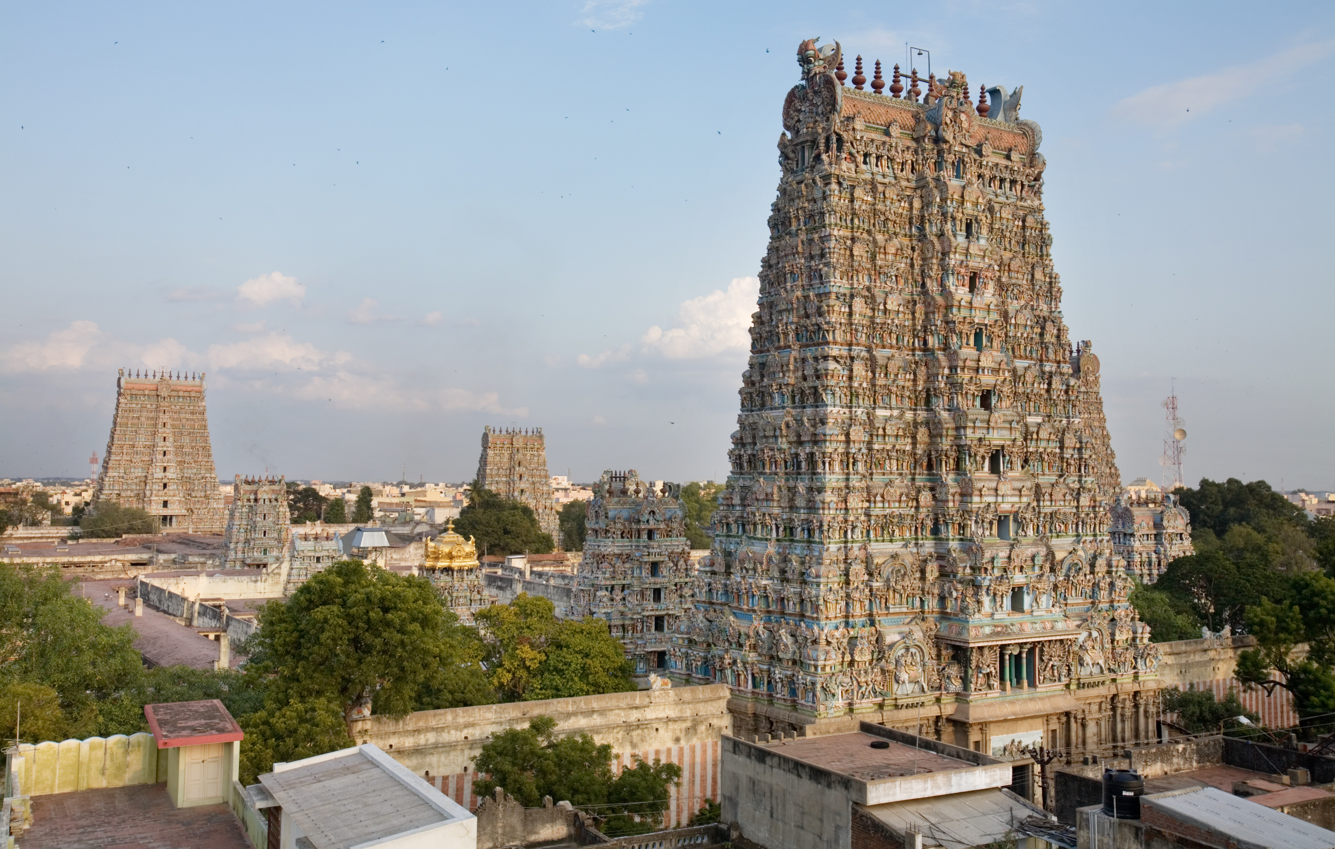 The towering Gopurams of Meenakshi Amman Temple, Madurai | |
 Madurai district Location in Tamil Nadu | |
| Coordinates: 09°50′N 077°50′E[1] | |
| Country | |
| State | |
| Municipal Corporations | Madurai |
| Headquarters | Madurai |
| Taluks | Madurai North, Madurai South, Madurai East, Madurai West, Melur, Peraiyur, Tirumangalam, Thiruparankundram, Usilampatti, Vadipatti, Kalligudi |
| Government | |
| • Type | District Administration |
| • Body | Madurai District Collectorate |
| • District Collector | Aneesh Sekhar, I.A.S. |
| • Superintendent of Police | Sujit Kumar, I.P.S. |
| Area | |
| • Total | 3,710 km2 (1,430 sq mi) |
| • Rank | 16 |
| Population (2011)[2] | |
| • Total | 3,038,252 |
| • Rank | 4 |
| • Density | 812/km2 (2,100/sq mi) |
| Languages | |
| • Official | Tamil and English |
| Time zone | UTC+5:30 (IST) |
| PIN | 625xxx |
| Telephone code | 0452 |
| Vehicle registration | TN-58, TN-59, TN-64[3] |
| Coastline | 0 kilometres (0 mi) |
| Largest city | Madurai |
| Sex ratio | ♂-50.5% / ♀-49.5% |
| Literacy | 81.5% |
| Lok Sabha constituency | 1 |
| Assembly constituency | 10 |
| Website | www |

History
Madurai is called by various nicknames like Athens of the East, Thoonga Nagaram (City that never Sleeps), Naan maada koodal (City of Four junctions), Malligai Managar (City of Jasmine), Koodal Managar (City of Junction) Koil Nagar (Temple city), etc. The main kingdoms which ruled Madurai during various times are the Pandyas and the Nayaks.[6]
Demographics
| Year | Pop. | ±% p.a. |
|---|---|---|
| 1901 | 666,940 | — |
| 1911 | 769,360 | +1.44% |
| 1921 | 800,795 | +0.40% |
| 1931 | 896,876 | +1.14% |
| 1941 | 1,014,602 | +1.24% |
| 1951 | 1,223,574 | +1.89% |
| 1961 | 1,378,734 | +1.20% |
| 1971 | 1,730,109 | +2.30% |
| 1981 | 2,042,704 | +1.67% |
| 1991 | 2,400,339 | +1.63% |
| 2001 | 2,578,201 | +0.72% |
| 2011 | 3,038,252 | +1.66% |
| source:[7] | ||
According to 2011 census, Madurai district had a population of 3,038,252[8] up from 2,578,201 in the 2001 census,[5] for a growth rate of 17.95%. It had a sex-ratio of 990 females for every 1,000 males, up from 978 in 2001,[5] and much above the national average of 929.[8] A total of 313,978 were under the age of six, constituting 162,517 males and 151,461 females. Scheduled Castes and Scheduled Tribes accounted for 13.46% and 0.37% of the population, respectively. The average literacy of the district was 74.83%, compared to the national average of 72.99%.[8]
The district had a total of 794,887 households. There were a total of 1,354,632 workers, comprising 81,352 cultivators, 287,731 main agricultural labourers, 39,753 in house hold industries, 765,066 other workers, 180,730 marginal workers, 11,367 marginal cultivators, 85,097 marginal agricultural labourers, 7,540 marginal workers in household industries and 76,726 other marginal workers.[9]
Politics
| District | No. | Constituency | Name | Party | Alliance | Remarks | ||
|---|---|---|---|---|---|---|---|---|
| Madurai district | 188 | Melur | Periyapullan @ P. Selvam | All India Anna Dravida Munnetra Kazhagam | NDA | |||
| 189 | Madurai East | P. Moorthy | Dravida Munnetra Kazhagam | UPA | ||||
| 190 | Sholavandan (SC) | A. Venkatesan | Dravida Munnetra Kazhagam | UPA | ||||
| 191 | Madurai North | G. Thalapathi | Dravida Munnetra Kazhagam | UPA | ||||
| 192 | Madurai South | M. Boominathan | Dravida Munnetra Kazhagam (MDMK) | UPA | ||||
| 193 | Madurai Central | Palanivel Thiagarajan | Dravida Munnetra Kazhagam | UPA | ||||
| 194 | Madurai West | Sellur K. Raju | All India Anna Dravida Munnetra Kazhagam | NDA | ||||
| 195 | Thiruparankundram | V. V. Rajan Chellappa | All India Anna Dravida Munnetra Kazhagam | NDA | ||||
| 196 | Tirumangalam | R. B. Udhayakumar | All India Anna Dravida Munnetra Kazhagam | NDA | ||||
| 197 | Usilampatti | P. Ayyappan | All India Anna Dravida Munnetra Kazhagam | NDA | ||||
Divisions
Madurai district comprises 13 talukas and revenue blocks, same names same boundaries. Under the gram panchayat system rural administration or the district is done by panchayat villages and the taluka headquarters. The revenue blocks are further sub-divided by firkas. The three taluks, Tiruparankundram, Madurai West and Madurai East, were created in February 2014.[10] The thirteen talukas/blocks are:[11][12][13]
- Thiruparankundram—7 firkas
- Peraiyur—3 firkas
- Tirumangalam—3 firkas
- Kalligudi
- Sedapatti
- Usilampatti
- Vadipatti
- Melur
- Madurai West
- Madurai East
- Alanganallur
- Madurai North
- Madurai South
2001 census

In the 2001 census, Madurai district had only seven talukas: Madurai North, Madurai South, Melur, Peraiyur, Thirumangalam, Vadipatti, and Usilampatti.[14]
Electoral divisions
| Assembly Constituency |
Political Party |
Elected Representative |
|---|---|---|
| Thirupparankundram | AIADMK | V. V. Rajan Chellappa |
| Usilampatti | AIADMK | P. Ayyappan |
| Madurai North | DMK | G. Thalapathi |
| Melur | AIADMK | Periya Pullan |
| Madurai East | DMK | P. Moorthy |
| Madurai Central | DMK | Palanivel Thiyagarajan |
| Sholavandan | DMK | A. Venkatesan |
| Tirumangalam | AIADMK | R. B. Udhaya Kumar |
| Madurai South | MDMK | Boominathan |
| Madurai West | AIADMK | K. Raju |
| Lok Sabha Constituency |
Political Party |
Elected Representative |
| Madurai | CPI(M) | S. Venkatesan |
| Source: Indian Elections / Election Commission of India.[15][16] | ||
Geography
The district is bounded by Theni in the west, Sivaganga in the east, Dindigul in the north, Virudhunagar in the south and small parts of Tiruchirappalli in the northeast. Madurai district witnessing hot and humid weather throughout the year and considered as hottest district of Tamil Nadu as well hottest city.
Climate
| Madurai | ||||||||||||||||||||||||||||||||||||||||||||||||||||||||||||
|---|---|---|---|---|---|---|---|---|---|---|---|---|---|---|---|---|---|---|---|---|---|---|---|---|---|---|---|---|---|---|---|---|---|---|---|---|---|---|---|---|---|---|---|---|---|---|---|---|---|---|---|---|---|---|---|---|---|---|---|---|
| Climate chart (explanation) | ||||||||||||||||||||||||||||||||||||||||||||||||||||||||||||
| ||||||||||||||||||||||||||||||||||||||||||||||||||||||||||||
| ||||||||||||||||||||||||||||||||||||||||||||||||||||||||||||
The climate has extremes. There are three distinct periods of rainfall:
- advancing monsoon period and south west monsoon from June to September, with strong southwest winds;
- north east monsoon from October to December, with dominant north east winds;
- dry season from January to May.
- Madurai District is the hottest district of Tamil Nadu throughout the year. district receives average rainfall and heavy heat which is prevails from March to September. madurai recorded 42℃ at the time of September month.
Tourist attractions
- Madurai Meenakshiamman temple
- Alagar temple
- Pazhamuthircholai (one of Abodes of Lord Murga)
- Gandhi Memorial Museum, Madurai (Erst while Rani Mangammal Palace)
- Thirumalai Nayakar Mahal
- Theppakulam, Vandiyur
- Madurai Maqbara
- Alanganallur jallikattu Madurai
- Thiruvathavur Thirumarainathar Temple and Birthplace of Manicka Vasakar
- Thirumohoor Kalamegaperumal Temple
- Thirupparamkunram Murugan temple
- 1000 Thoon Mandapam (1000 pillar hall)
- Eco park
- Kuruvithurai Vallaba Perumal Temple
- Vaigai Dam (nearby)
- Anaipatti Anjaneyar Temple
- Kodaikanal (nearby)
- Suruli falls (nearby)[17]
- Kutladampatti falls
- Kazimar Big Mosque, situated on the banks of Kiruthumal river (the oldest mosque in Madurai)
See also
- List of districts of Tamil Nadu
References
- Madurai (Approved) at GEOnet Names Server, United States National Geospatial-Intelligence Agency
- "District Census 2011". Registrar General & Census Commissioner, India. 2011. Archived from the original on 5 May 2012. Retrieved 30 September 2011.
- "Registration Series Allotted to Regional Transport Offices" (PDF). Government of Tamil Nadu, State Transport Authority. Archived (PDF) from the original on 12 September 2012.
- "Madurai District, Government of Tamilnadu | Athens of the East | India". Retrieved 15 January 2021.
- "Census of India 2001: Basic data Sheet: Madurai District, Tamil Nadu" (PDF). The Registrar General and Census Commissioner.
- "Madurai". britannica.com.
- Decadal Variation In Population Since 1901
- "Census Info 2011 Final population totals". Office of The Registrar General and Census Commissioner, Ministry of Home Affairs, Government of India. 2013. Retrieved 26 January 2014.
- "Census Info 2011 Final population totals - Krishnagiri district". Office of The Registrar General and Census Commissioner, Ministry of Home Affairs, Government of India. 2013. Retrieved 26 January 2014.
- Mariappan, Julie (12 February 2014). "23 new taluks created in Tamil Nadu". The Times of India. Archived from the original on 19 April 2014.
- "Map: Madurai District Blocks". Madurai District. Archived from the original on 9 July 2018. Retrieved 22 November 2010.
- "Reports of National Panchayat Directory: Village Panchayat Names of Madurai, Tamil Nadu". Ministry of Panchayati Raj, Government of India. Archived from the original on 13 November 2011.
- "Revenue Administration | Madurai District, Government of Tamilnadu | India". Retrieved 29 November 2020.
- "2001 Census of India: List of Villages by Tehsil: Tamil Nadu" (PDF). Registrar General & Census Commissioner, India. pp. 245–256. Archived (PDF) from the original on 13 November 2011.
- "Election results". Indian Elections. Archived from the original on 8 December 2012.
- "Parties Statistics". Election Commission of India. Archived from the original on 18 December 2008.
- Suruli Falls Suruli falls
External links
Capital: Chennai | ||
| State symbols |
| |
| Governance |
| |
| Topics |
| |
| Major cities | ||
| Districts |
| |
| Lists |
| |
Authority control | |
|---|---|
| General | |
| National libraries | |
На других языках
[de] Madurai (Distrikt)
Der Distrikt Madurai (Tamil: மதுரை மாவட்டம்; früher Madura) ist ein Distrikt des indischen Bundesstaates Tamil Nadu. Verwaltungszentrum ist das namensgebende Madurai, die drittgrößte Stadt Tamil Nadus, die auf eine über zweitausendjährige Geschichte zurückblicken kann. Der Distrikt Madurai hat eine Fläche von 3.710 Quadratkilometern und rund 3,0 Millionen Einwohner (Volkszählung 2011).- [en] Madurai district
[ru] Мадурай (округ)
Мадурай (англ. Madurai) — округ в индийском штате Тамилнад. Административный центр — город Мадурай. Площадь округа — 3497 км². По данным всеиндийской переписи 2001 года население округа составляло 2 578 201 человек. Уровень грамотности взрослого населения составлял 77,8 %, что выше среднеиндийского уровня (59,5 %). Доля городского населения составляла 56 %.Другой контент может иметь иную лицензию. Перед использованием материалов сайта WikiSort.org внимательно изучите правила лицензирования конкретных элементов наполнения сайта.
WikiSort.org - проект по пересортировке и дополнению контента Википедии