world.wikisort.org - India
Pahalgam (Hindustani pronunciation: [pɛhɛlɡaːm]), known as Pahalgom (Kashmiri pronunciation: [pəhəlʲɡoːm]; lit. 'village of shepherds' in Kashmiri)[3] is a town and a notified area committee, near Anantnag city in the Anantnag district of the Indian-administered union territory of Jammu and Kashmir.[4][5][6][7][8] It is a popular tourist destination and hill station. Its lush green meadows and pristine waters attract thousands of tourists from all over the world each year.[9] It is located 45 kilometres (28 mi) from Anantnag on the banks of Lidder River at an altitude of 7,200 feet (2,200 m). Pahalgam is the headquarters of one of the eleven tehsils of Anantnag district.
Pahalgam
Pahalgom | |
|---|---|
Town | |
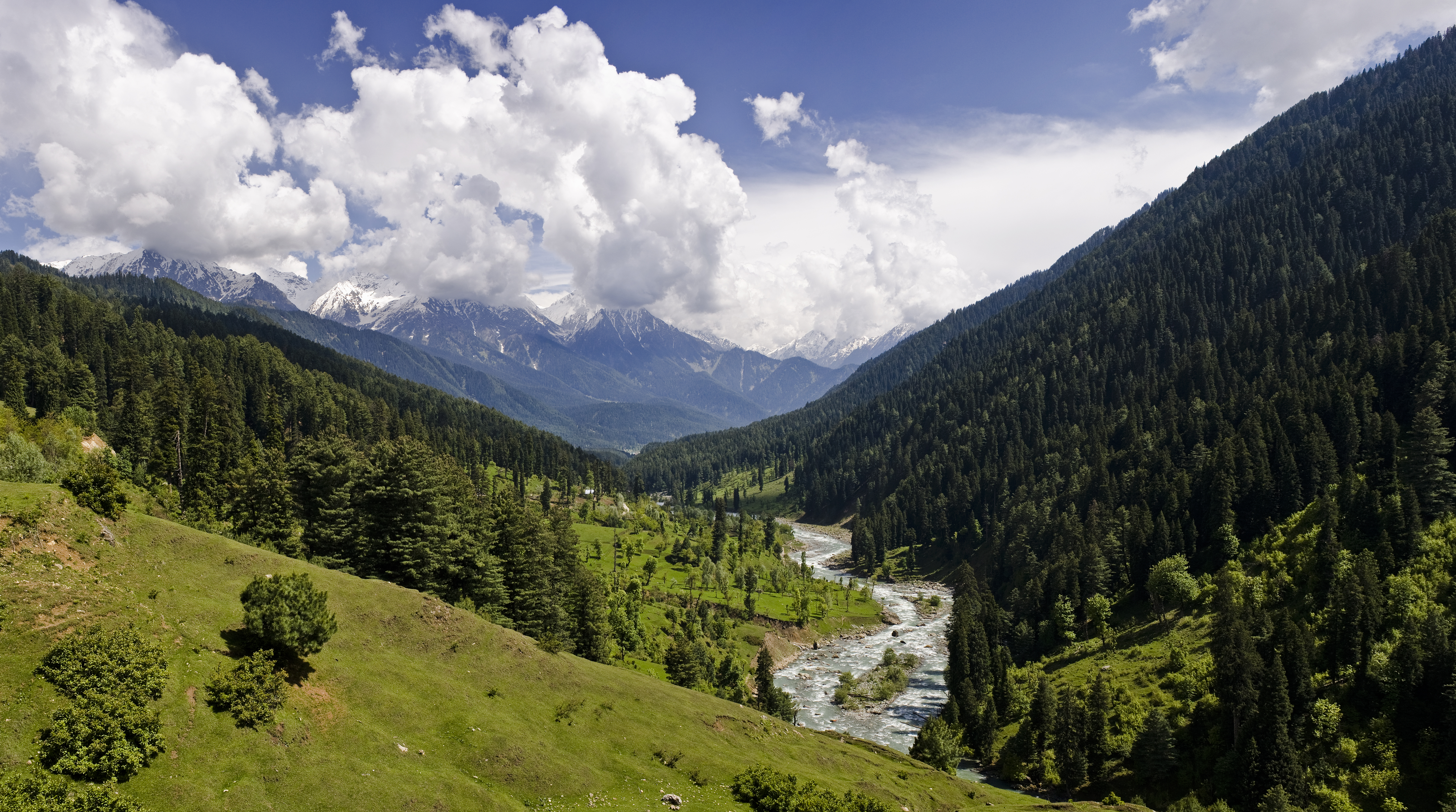 View of valley in Pahalgam town, Anantnag district, Jammu and Kashmir, India | |
 Pahalgam Location in Jammu and Kashmir, India  Pahalgam Pahalgam (India) | |
| Coordinates: 34.01°N 75.19°E | |
| Country | |
| Union Territory | |
| District | Anantnag |
| Elevation | 2,740 m (8,990 ft) |
| Population (2011) | |
| • Total | 5,922 |
| Languages | |
| • Official | Kashmiri, Urdu, Hindi, Dogri, English[1][2] |
| Time zone | UTC+5:30 (IST) |
| PIN | 192126 |
| Vehicle registration | JK-03 |
| Website | anantnag |
Pahalgam is associated with the annual pilgrimage to the shrine Amarnath Yatra. Chandanwari, located 16 kilometres (9.9 mi) from Pahalgam. The town is the starting point of the yatra that takes place every year in the months of July–August, receiving hundreds of thousands of tourists. Because of its religious significance and role as a base camp, the town attracts 70% of visitors to the valley.[10] This flood of tourists overwhelms some of the local infrastructure, especially waste management in the town.[10]
Etymology
The name Pahalgam is derived from two Kashmiri words;
Puheyl and Goam, wherein Puheyl means Shepherd and Goam means Village, this over the time became Puheylgoam or Pahalgam. It is because the place acts as a gateway to many meadows & pastures and traditional Bakharwal communities settle in those places from spring season to pre winter to herd their cattle. Hence the name "Valley of Shepherds" which it has been referred to as by various Governmental Bodies to exotify it and turn it into a brawling tourist hub.
According to Hindu traditions, Pahalgam was originally called Bail Gaon (बैल गाँव) meaning (village of bull (nandi)) where Hindu God Shiva left his bull before entering Amarnath Cave[11]
Geography
Pahalgam is located at 34.01°N 75.19°E.[12] Pahalgam holds a central position in the Lidder Valley. It has an average elevation of 2,740 metres (8,990 ft).
Climate
Pahalgam has a temperate climate with long and cold winter and short and mild summer.
| Climate data for Pahalgam (1981–2010, extremes 1978–2012) | |||||||||||||
|---|---|---|---|---|---|---|---|---|---|---|---|---|---|
| Month | Jan | Feb | Mar | Apr | May | Jun | Jul | Aug | Sep | Oct | Nov | Dec | Year |
| Record high °C (°F) | 13.2 (55.8) |
17.0 (62.6) |
23.5 (74.3) |
27.4 (81.3) |
30.8 (87.4) |
32.0 (89.6) |
31.5 (88.7) |
32.2 (90.0) |
30.0 (86.0) |
27.7 (81.9) |
23.0 (73.4) |
15.6 (60.1) |
32.2 (90.0) |
| Average high °C (°F) | 4.4 (39.9) |
6.6 (43.9) |
11.7 (53.1) |
17.4 (63.3) |
21.0 (69.8) |
24.4 (75.9) |
25.3 (77.5) |
25.5 (77.9) |
23.8 (74.8) |
19.4 (66.9) |
12.9 (55.2) |
7.2 (45.0) |
16.6 (61.9) |
| Average low °C (°F) | −6.9 (19.6) |
−4.8 (23.4) |
−0.6 (30.9) |
3.1 (37.6) |
5.6 (42.1) |
8.5 (47.3) |
12.4 (54.3) |
12.6 (54.7) |
8.3 (46.9) |
2.3 (36.1) |
−1.6 (29.1) |
−4.1 (24.6) |
2.9 (37.2) |
| Record low °C (°F) | −18.6 (−1.5) |
−17.3 (0.9) |
−11.6 (11.1) |
−4.2 (24.4) |
−1.0 (30.2) |
1.5 (34.7) |
5.0 (41.0) |
4.0 (39.2) |
0.6 (33.1) |
−5.1 (22.8) |
−10.6 (12.9) |
−15.7 (3.7) |
−18.6 (−1.5) |
| Average rainfall mm (inches) | 120.3 (4.74) |
139.2 (5.48) |
198.0 (7.80) |
141.6 (5.57) |
129.9 (5.11) |
88.0 (3.46) |
109.1 (4.30) |
109.8 (4.32) |
81.4 (3.20) |
46.2 (1.82) |
42.9 (1.69) |
75.1 (2.96) |
1,281.5 (50.45) |
| Average rainy days | 7.9 | 8.9 | 10.9 | 9.9 | 9.9 | 8.5 | 9.0 | 9.0 | 6.5 | 3.7 | 2.9 | 4.9 | 91.9 |
| Average relative humidity (%) (at 17:30 IST) | 82 | 77 | 68 | 60 | 57 | 57 | 65 | 67 | 62 | 59 | 67 | 75 | 66 |
| Source: India Meteorological Department[13][14] | |||||||||||||
Demographics
Religion in Pahalgam Town (2011)[15]
As of 2011[update] India census,[16] Pahalgam had a population of 5922. Males constitute 56% of the population and females 44%. The average literacy rate is 35%, lower than the Indian national average of 59.5% with male literacy at 49% and female literacy at 17%. About 14% of the population is under 6 years of age.
Administration
Pahalgam is administered by the Pahalgam Development Authority, headed by a Chief Executive Officer who functions as the administrator of local town area committee.
Tourism
The town has 3,510 rooms with 7,020 beds for tourists.[10]
Amarnath Temple
Amarnath cave is a Hindu shrine located in Pahalgam. The cave is situated at an altitude of 3,888 m (12,756 ft).[17]
Kolhoi Glacier
Kolohoi Glacier, situated up the Lidder Valley, just below Kolhoi Peak is currently a hanging glacier. It is accessible from Pahalgam via Aru and is known to have extended for at least 35 kilometres (22 mi).[18] According to the mountaineers from Jawahar Institute of Mountaineering, in 2008, the glacier receded by half since 1985 and it is not safe to study because it is hollow and has 200-foot-deep (61 m) crevices.
Betaab Valley
Also known as Hagoon or Hagan Valley, locally.
Betaab Valley is a valley located 15 kilometres (9.3 mi) from Pahalgam. The valley got its name from a Bollywood movie Betaab that was shot here.
Baisaran Valley
Baisaran Valley, barely 5 kilometres from Pahalgam in Kashmir's Anantnag district, is a popular tourist attraction that has been dubbed "mini-Switzerland" due to its scenic splendour. It's a verdant meadow on a mountaintop flanked by snowcapped mountains and studded with thick pine woods.[19] The optimum time to go to Baisaran is determined on the type of experience you wish to have. From January through March is the best time to visit if you want to experience the snow. Visit there during April and June to appreciate the foliage and lovely weather.[20]
Religious significance
Pahalgam is one of the most important site for Hindus.[21] Amarnath cave situated at 3,888 m (12,756 ft) is an important Hindu shrine located in Pahalgam.[22]
Mythology
Lord Shiva is believed to impart the secret of immortality (Amrit Vachan) to Parvati in Pahalgam. Before entering Amarnath cave Shiv left nandi in Pahalgam, moon in Chandanwari, snakes in Sheshnag Lake, Ganesha on Mahaguna Parbat, five elements at Panchtarni.[23] Mahaguna Parbat is lies at Nagaparbhat.
Environmental issues
Annual tourist flow to the town produces much more waste than locals, overwhelming the local solid waste management system, and leading to dumping of waste throughout the town.[10] 74% of the total municipal waste comes from the tourism sector.[10] This waste issue increase waterborne disease downstream and other health issues, as well as polluting the local landscape.[10]
Pahalgam Golf Course

Pahalgam has a scenic 9-hole golf course; where championships are organized by the state government and private hoteliers in the summers. The course remains closed in winters due to snowfall. Club.[24] Pahalgam Golf Course is approximately 100 km from Srinagar and situated at an altitude of 2150 metres. The course is an expanse of relatively large plain area in a relatively narrow valley. The locals would refer to this golf course simply as the 'plateau'. Portions of the plateau have been occupied by the military in the days of insurgency, leaving it out of bound of normal tourists. Mini-golf could also be played at the Pahalgam Club.[25]
Transportation
Air
The nearest airport is Sheikh ul-Alam International Airport in Srinagar located 91 kilometres from Pahalgam.
Rail
Pahalgam is not connected with railways. The nearest railway station is Bijbehara railway station located 45 kilometres from Pahalgam.
Road
Pahalgam is well-connected with roads and highways. The NH 501 passes through Pahalgam alongside other intra-district roads.
Gallery
- Pahalgam Gallery
 A view of Pahalgam valley
 Pine trees in the snow in Pahalgam
 Meadows in Pahalgam
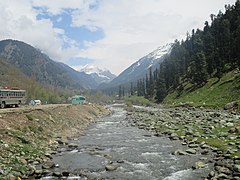
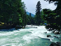 Lidder River
 Route to Amarnath Temple
 View of valley near Pahalgam town


See also
- Kashmir
- Indian-administered Jammu and Kashmir
- Ladakh
- Kashmir Division
- Jammu Division
- Jammu
- Sonamarg
- Sopore
- Aharbal
- Kausar Nag
- Gulmarg
- Martand Sun Temple
References
- "The Jammu and Kashmir Official Languages Act, 2020" (PDF). The Gazette of India. 27 September 2020. Retrieved 27 September 2020.
- "Parliament passes JK Official Languages Bill, 2020". Rising Kashmir. 23 September 2020. Archived from the original on 24 September 2020. Retrieved 23 September 2020.
- Betts, Vanessa; McCulloch, Victoria (2014). Footprint Delhi & Northwest India. Footprint Travel Guides. p. 158. ISBN 9781910120866.
- "Vale of Kashmir | valley, India". Encyclopædia Britannica. Archived from the original on 16 July 2015. Retrieved 30 July 2022.
- "Jammu and Kashmir | union territory, India". Encyclopædia Britannica. Archived from the original on 19 June 2015. Retrieved 30 July 2022.
- "Jammu and Kashmir summary". Encyclopædia Britannica. Archived from the original on 4 November 2021. Retrieved 30 July 2022.
- "Kashmir | Region, Indian subcontinent". Encyclopædia Britannica. Archived from the original on 17 June 2015. Retrieved 30 July 2022.
- "Kashmir summary". Encyclopædia Britannica. Archived from the original on 21 November 2021. Retrieved 30 July 2022.
- "Pahalgam: Valley of paradise". Bangalore Mirror. 24 June 2010. Archived from the original on 1 May 2013.
- Bashir, Subzar; Goswami, Subhrangsu (1 January 2016). "Tourism Induced Challenges in Municipal Solid Waste Management in Hill Towns: Case of Pahalgam". Procedia Environmental Sciences. Waste Management for Resource Utilisation. 35: 77–89. doi:10.1016/j.proenv.2016.07.048. ISSN 1878-0296.
- Hazra, Rajendra Chandra (2003). Rise of Epic and Purāṇic Rudra-Śiva Or Śiva Maheśvara. Sri Balaram Prakashani. p. 71.
- "Falling Rain Genomics, Inc – Pahalgam". fallingrain.com. Retrieved 1 May 2016.
- "Station: Pahalgam Climatological Table 1981–2010" (PDF). Climatological Normals 1981–2010. India Meteorological Department. January 2015. pp. 605–606. Archived from the original (PDF) on 5 February 2020. Retrieved 15 March 2020.
- "Extremes of Temperature & Rainfall for Indian Stations (Up to 2012)" (PDF). India Meteorological Department. December 2016. p. M78. Archived from the original (PDF) on 5 February 2020. Retrieved 15 March 2020.
- "Pahalgam population". Census India 2011. Retrieved 10 July 2021.
- "Census of India 2001: Data from the 2001 Census, including cities, villages and towns (Provisional)". Census Commission of India. Archived from the original on 16 June 2004. Retrieved 1 November 2008.
- "Archive News". Retrieved 14 July 2020.
- N. Ahmed and N. H. Hashimi (1974). "Glacial History of Kolahoi Glacier, Kashmir, India" (PDF). Journal of Glaciology. 13 (68): 279. Bibcode:1974JGlac..13..279A. doi:10.1017/S002214300002308X. Archived from the original (PDF) on 11 December 2013. Retrieved 16 April 2012.
- "Baisaran Valley". ExploreKashmir - SimplyKashmir Blog. Retrieved 22 September 2021.
- "Baisaran Valley Pahalgam | Top Things to Do & Best Time to Visit | J & K Tourism". tour-my-india. Retrieved 22 September 2021.
- Incredible India : tourist & travel guide. Jodhpur: Indian Map Service. 2007. ISBN 978-81-89875-20-6. OCLC 156848033.
The Shiva is one of the most important Hindu traditional route from Pahalgam to Amarnath pilgrimage centres in the country. The holy cave via Chandanwari, Sheshnag and Panchtarni perched at an altitude of 3962 metres is 2 feet is endowed ...
- "Archive News". Retrieved 14 July 2020.
- Sunita Pant Bansal. (15 November 2012). Hindu pilgrimage;a journey through the holy places of hindus all over india. [Place of publication not identified]: V & S Publishers. p. 121. ISBN 978-93-5057-251-1. OCLC 930451370.
- "List of Top 5 Golf Courses in Kashmir – Swan Tours – Blogs".
- "Official Website of Department of Tourism Govt of Jammu & Kashmir". www.jktourism.jk.gov.in. Retrieved 19 January 2021.
Capital: Srinagar (Summer); Jammu (Winter) | |||||
| History |
| ||||
| Government and politics |
| ||||
| Culture and places | |||||
| Districts and divisions |
| ||||
| Cities | |||||
| Towns |
| ||||
| Famous villages | |||||
| Regions |
| ||||
| Railways | |||||
| Roads |
| ||||
| Local elections |
| ||||
| Sports |
| ||||
| Other topics |
| ||||
Kashmir Valley | ||
|---|---|---|
| Passes |
|  |
| Valleys |
| |
| Cities | ||
| Towns |
| |
| Rivers | ||
| Glaciers |
| |
| Lakes | ||
| Mountains | ||
| Hill stations and Mughal gardens | ||
| Protected Areas |
| |
| See also |
| |
На других языках
[de] Pahalgam
Pahalgam ist eine Kleinstadt (Municipal Committee) mit etwa 9500 und der Hauptort eines Sub-Distrikts (tehsil) mit etwa 12.000 Einwohnern im Distrikt Anantnag im indischen Unionsterritorium Jammu und Kaschmir.- [en] Pahalgam
[ru] Пахалгам
Пахалгам (Урду: پہلگام, Хинди: पहलगाम) — город и техсил в округе Анантнаг, Джамму и Кашмир, Индия.Другой контент может иметь иную лицензию. Перед использованием материалов сайта WikiSort.org внимательно изучите правила лицензирования конкретных элементов наполнения сайта.
WikiSort.org - проект по пересортировке и дополнению контента Википедии