world.wikisort.org - India
Orai is a city in Uttar Pradesh, India. It is the administrative headquarters of Jalaun District. All administrative offices of Jalaun District, including the District Collectorate, police, telecom and various other government organizations are located in this city. Orai received the award of 'Fastest Mover' Small City among India[2] (0.8-3.1 Lakh) under Swachh Survekshan 2019, an annual cleanliness survey carried by the Quality Council of India.
This article may require copy editing for grammar, style, cohesion, tone, or spelling. (May 2022) |
Orai | |
|---|---|
City | |
 Orai Location in Uttar Pradesh, India | |
| Coordinates: 25.98°N 79.47°E | |
| Country | |
| State | Uttar Pradesh |
| District | Jalaun |
| Founded by | Raja Mahil Parihar |
| Named for | Saint Uddalak |
| Government | |
| • MP | Bhanu Pratap Singh Verma (BJP) |
| • MLA | Gauri Shankar Verma (BJP) |
| Elevation | 131 m (430 ft) |
| Population (2011)[1] | |
| • Total | 190,575 |
| Languages | |
| • Official | Hindi |
| Time zone | UTC+5:30 (IST) |
| PIN | 285001 |
| Telephone code | +915162 |
| Vehicle registration | UP-92 |
| Sex ratio | 0.842 ♂/♀ |
| Literacy | 83.35% |
| Website | jalaun.nic.in |

History and historical importance of Orai
This section does not cite any sources. (July 2022) |
Orai was named after Saint Uddalak because he worshiped there. The city has historical value because of its location, which is between Jhansi, Mahoba and Kalpi.
Alha and Udal of the Banaphar clan were legendary generals of the Chandela king Paramardi, who fought Prithviraj Chauhan in 1182 CE.
The town of Kalpi on the Yamuna was conquered by the armies of Muhammad of Ghor in 1196. Early in the 14th century the Bundelas occupied the greater part of Jalaun, and even succeeded in holding the fortified post of Kalpi. During 1553–56, the Hindu Prime Minister and Chief of Army of Suri empire Hemu won this area. Later, on 7 October 1556, he was crowned Emperor of northern India at Delhi. He established Hindu Raj in northern India and acquired the title of Vikramaditya. After Hem Chandra Vikramaditya's death at the second battle of Panipat, this important possession was soon recovered by Akbar's army, and passed under the way of the Mughal Empire. Akbar's governors at Kalpi maintained a nominal authority over the surrounding district, and the Bundela chiefs were in a state of chronic revolt, which culminated in the war of independence under Maharaja Chhatrasal. During the outbreak of his rebellion in 1671 he occupied a large province to the south of the Yamuna. Setting out from this base, and assisted by the Marathas, he conquered the whole of Bundelkhand. On his death in 1732 he bequeathed one-third of his dominions to his Maratha allies, who before long succeeded in annexing the whole of Bundelkhand. Under Maratha rule, the country was a prey to constant anarchy and strife. In 1806 Kalpi was turned over to the British, and in 1840, on the death of Nana Gobind Ras, his possessions lapsed to them also. Various interchanges of territory took place, and in 1856 the boundaries of the British district were substantially settled, with an area of 1477 square miles.

Orai, Jalaun was the scene of much violence during the Revolt of 1857. When the news of the rising at Kanpur reached Kalpi, the men of the 53rd Native Infantry deserted their officers, and in June the Jhansi rebels reached the district and began their murder of Europeans. It was not until September 1858 that the rebels were finally defeated. In the later 19th century, the district suffered much from the invasive kans grass (Saccharumspontaneum). Many villages were abandoned, their land no longer suitable for cultivation. The population of the district was 399,726 in 1901, and the two largest towns were Konch and Kalpi (pop. 10,139 in 1901). The district was traversed by the line of the Indian Midland railway from Jhansi to Kanpur. A small part of it is watered by the Bethwa Canal. Grain, oil-seeds, cotton and ghee were exported.
Orai participated in the freedom struggle under the leadership of Bundelkhand Kesri Dewan Shatrughan Singh and Rani Rajendra Kumari, the founders of the freedom movement in Bundelkhand. Their ancestral fort in Mangrauth is on one side of the river Betwa; the other side of the Betwa is Jalaun, where Orai is located.
After 1990
Orai has changed after 1990. Major changes came because of the industrial area, HUL (Hindustan Unilever LTD) and many others. After 1990, schools, colleges, roads and many more were built.
Climate
Orai has a composite climate, with high temperatures in summer and low in winter. Relative humidity remains about 40-50%. The climate of the Orai district is characterized by a hot summer and general dryness, except for rainfall during the southwest monsoon season. The year has four seasons. The cold season lasts from December to February; January's minimum temperature is 7.1 C. The hot season is from March until the first week of June. May is the hottest month of the year with an average temperature of 42.1 C. The southwest monsoon runs from the middle of June until the end of September. October and middle of November constitute the post-monsoon or retreating monsoon season. The normal annual rainfall of Orai is 793.8 mm. About 90.4% of annual rainfall is received during monsoon season; only 9.6% of annual rainfall takes place between October to May. The humidity is lowest in April and varies between 26% and 83% throughout the year.
Demographics
According to the Orai City Census data from 2011, the literacy rate was 82.35 percent.
Overview
The city of Orai is governed by the Municipal Corporation, which comes under Orai Metropolitan Region. The city is located in the state of Uttar Pradesh in India. The total area of Orai Is 20.86 km2.
The population of Orai in 2016 was 217,389, of which males and females comprised 111,987 and 105,402 respectively.
In 2011, there were 880 females for every 1000 males. The ratio for children was 845 girls for every 1000 boys.
Children numbered 31,011 in Orai in 2016. There were 17,859 boys and 13,152 girls. Children form 7.01% of the total population of the city.[3]
Ramkund Park
Ramkund Park is a recreational place with a paved walkway around a small water pond. Locals visit the park for their morning walk. It is located near Thadeshwari Maharaj Mandir (Sri Hanuman Mandir) and every year on "Budhwa Mangal", a large crowd from surrounding villages gathers for festivals of prayer for Lord Hanumana.
Radha Krishna Mandir
"Shri Radha Krishna Mandir" is a sacred temple located in Galla Mandi.
Transport
Railway
Orai railway station is the main railway station, sitting between the Kanpur-Jhansi section and a well connected with the east, west & southern parts of India via rail.
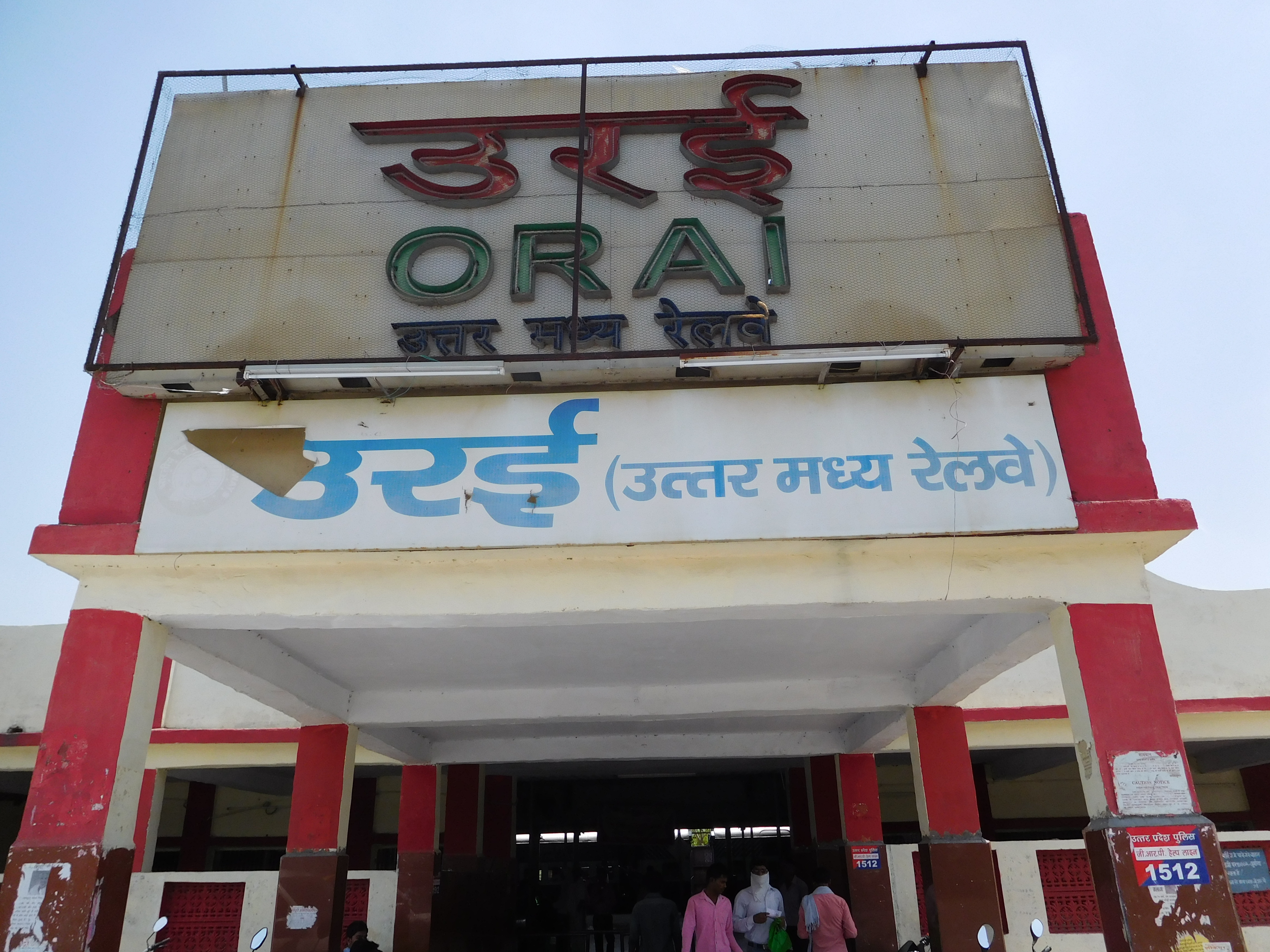
The existing railway line, (North Central Railway), runs from Jhansi to Kanpur. It has been electrified, and a doubling of the track is in progress. Orai's railway station is categorized as a "model railway station".
Many trains such as the Jhansi-Lucknow Intercity Express, Lucknow-Mumbai AC Express, Gwalior-Barauni Mail, Kushinagar Express, Sabarmati Express, Pratham Swatantrata Sangram Express and many more trains have a departure in Orai.
Airports
Kanpur Airport, located in Chakeri near Kanpur, is the nearest airport. Flights to Delhi and Varanasi are operational from the airport. The nearest international airport is at Lucknow, which is about 200 kilometers away. The government has proposed setting up an international airport near Kanpur in the Kanpur dehat district, which would be in close proximity to the town. Gwalior Airport is 156 km from Orai by road.[4]
Highway and roads system
An inter state bus terminus helps connect Orai with the rest of the state and adjacent states as well. The East-West Corridor passes through Orai, connecting it to cities like Delhi, Gwalior, Gorakhpur, Kanpur, Jhansi, Lucknow, Kota, Udaipur, Kolkata, Ahmedabad, and others. Within the city, Tempo, e-rickshaw and cycle rickshaw are the major forms of city transport.
Medical College
- Government Medical College, Jalaun is a government medical college located in Orai.
Citations
- "Madhya Pradesh (India): State, Major Agglomerations & Cities – Population Statistics, Maps, Charts, Weather and Web Information". citypopulation.de. Retrieved 2 January 2021.
- "Swachh Survekshan 2019". swachhsurvekshan2019.org. Retrieved 20 September 2019.
- "Urban Agglomerations/Cities having population 1 lakh and above" (PDF). Provisional Population Totals, Census of India 2011. Retrieved 7 July 2012.
- "Gwalior to Orai Distance, Duration, Driving Direction by Road, Trains, Bus / Car at MakeMyTrip Route Planner". www.makemytrip.com.
External links
 Orai travel guide from Wikivoyage
- Jalaun District website
| Authority control |
|
|---|
На других языках
[de] Orai (Stadt)
Orai (Hindi .mw-parser-output .Deva{font-size:120%}@media all and (min-width:800px){.mw-parser-output .Deva{font-size:calc(120% - ((100vw - 800px)/80))}}@media all and (min-width:1000px){.mw-parser-output .Deva{font-size:100%}}उरई .mw-parser-output .Latn{font-family:"Akzidenz Grotesk","Arial","Avant Garde Gothic","Calibri","Futura","Geneva","Gill Sans","Helvetica","Lucida Grande","Lucida Sans Unicode","Lucida Grande","Stone Sans","Tahoma","Trebuchet","Univers","Verdana"}Uraī; Urdu: اورئ) ist eine Stadt im nordindischen Bundesstaat Uttar Pradesh.- [en] Orai
[ru] Орай (город)
Орай (англ. Orai, хинди उरई) — город в южной части штата Уттар-Прадеш, Индия. Административный центр округа Джалаун.Другой контент может иметь иную лицензию. Перед использованием материалов сайта WikiSort.org внимательно изучите правила лицензирования конкретных элементов наполнения сайта.
WikiSort.org - проект по пересортировке и дополнению контента Википедии