world.wikisort.org - India
Kalpi is a historical city and municipal board in Jalaun district in Uttar Pradesh, India. It is on the right bank of the Yamuna.[2] Once Kalpi was more important Than Orai It is situated 78 kilometres south-west of Kanpur from which it is connected by both road and rail.
Kalpi
Kalpriya | |
|---|---|
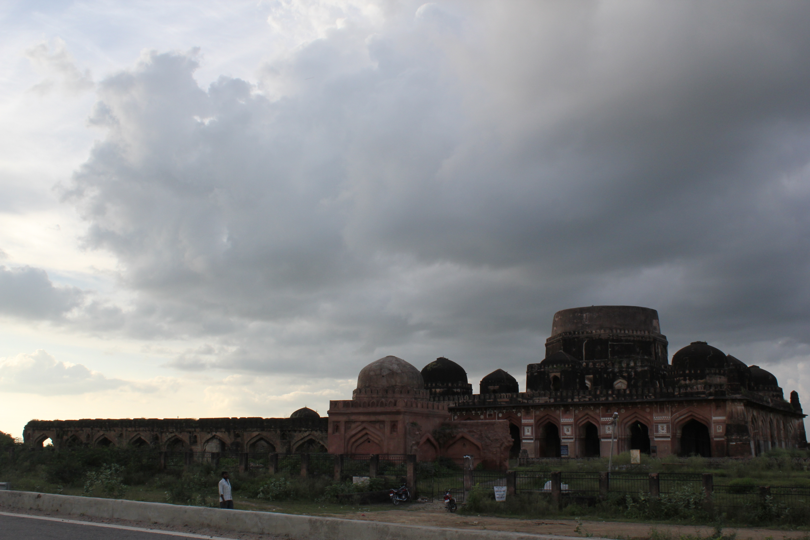 South facing view of Chaurasi Gumbad | |
 Kalpi  Kalpi | |
| Coordinates: 26.12°N 79.73°E | |
| Country | India |
| State | Uttar Pradesh |
| District | Jalaun |
| Founded by | Vasu Dev |
| Government | |
| • Type | Municipality |
| • Body | Nagar Palika Parishad |
| • Chairman | Baikunthi Devi |
| Elevation | 112 m (367 ft) |
| Population (2011) | |
| • Total | 51,670 |
| Languages | |
| • Official | Hindi |
| Time zone | UTC+5:30 (IST) |
| PIN | 285204[1] |
| Vehicle registration | UP 92 |
| Website | up |


People from Kalpi
Ved Vyas Ji
History
Ancient
It is believed that the city was known as Kalap dev ki kalpi in ancient times, later abbreviated to Kalpi. Kalpi is also known as the birthplace of Sage Vyasa, the writer of the Mahabharata and Puranas. He collected the chants of Vedas and assembled them in an arranged manner. Kalpi is said to have been founded by King Vasudeva at the end of the 4th century BCE.
Medieval
In 1196 it fell to Qutb-ud-din Aibak, the viceroy of Mohammed Ghori, and during the subsequent Muslim period it played a significant part in the history of central India. In the early 16th Century Rajput king of Chittor Rana Sanga defeated Ibrahim Lodhi twice and establish his control over some parts of Uttar Pradesh including Kalpi and Chandawar and appointed Manik Chand Chauhan to rule there.[3] Rana Sanga also died in Kalpi in January 1528 poisoned by his own Nobles.[4] The city was then captured by the Mughals under Babur. During Akbar's reign, Kalpi was a governor's seat and had a mint for copper coinage.[2] The witty Raja Birbal of Akbar's court is considered to be born near this city. About the middle of the 18th century the city was lost by the Mughals and it passed into the hands of the Marathas.[2]
Modern
The town was captured by the British in 1803, and after 1806 remained in British possession[2] until India's independence in 1947. Kalpi was a part of Bundelkhand Agency, formed in 1811, and also housed its headquarters from 1818 to 1824. During this period the political agent to Governor General of India was appointed and headquartered in Kalpi. The British East India Company made it one of their principal stations for providing "commercial investment".[2] In May 1858 Hugh Rose (Lord Strathnairn) defeated here a force of Indian rebels led by the Rani of Jhansi.[2] The fortified post of Kalpi, the former residence of the rulers of Jalaun State, was dismantled in 1860 by the British and its place was taken by a market known as Whiteganj.[5] Tourist sites include Vyas temple, Lanka Meenar, 84 Gumbaj and many Dargah like Dargah of Meer Syed Mohammad Tirmizi, and Sufi Khanqah colled Khanqahe Muhammadia, Kalpi is also the birthplace of Ved Vyas ji. There is a Kali Haveli and Rang Mahal of Beerbal named Rang Mahal.
Geography
Kalpi is located at 26.12°N 79.73°E.[6] It has an average elevation of 112 metres (367 feet).The climate in Kalpi is warm and temperate. The rainfall in Kalpi is significant, with precipitation even during the driest month. The temperature averages 25.9 °C. The average annual rainfall is 892 mm.[7]
Location
The old town, which is on the Yamuna river has the ruin of a fort, and several temples of interest, while in the neighborhood are many ancient tombs.[2] Away from the river to the south-east is a lofty modern town ornamented with representations of the battles of the Ramayana.
The Gaud Sarasawath Brahmin (GSB) community who are followers of Kashi Math Samsathan Varanasi has set up a temple of Shri Bala Veda Vyasa in memory of the great sage Veda Vyasa. In 1998 Sudhindra Thirtha, the swami of Kashi Math Samsthan, envisioned setting this temple right at the birthplace of Veda Vyasa. It is also a tourist attraction.[8][9]
Economy
Kalpi is still a centre of local trade (principally in grain, ghee and cotton) with a station on the North Central Railway (India) line from Jhansi to Kanpur, which crosses the Yamuna here.[2] In late 1970s and early 1980s, Kalpi was one of the areas in central India affected by dacoits, and was frequented by the much dreaded Phoolan Devi gang. It has been declared an industrial belt by the Government of India and handmade paper is produced there.
Transport
Railways
Kalpi is a major Railway Station of Kanpur-Jhansi railway section of North Central Railway.

Roadways
Kalpi lies on NH 27 on Kanpur-Jhansi section of National Highway. It is connected to cities of Kanpur, Jhansi and Orai by UPSRTC Buses at Kalpi bus station.
Airways
The nearest airport is at Kanpur near Chakeri (100 kilometres) which has direct flights to Delhi, Mumbai and Kolkata but is expected to be connected to major cities of India by 2021.
Gallery
 The British Memorial Cemetery on the banks of Yamuna River
 The majestic British Cemetery situated next to River Yamuna
 Yamuna River (road bridge)


References
- "Kalpi Pincode 285204 STD code 05164".
- Chisholm, Hugh, ed. (1911). . Encyclopædia Britannica. Vol. 15 (11th ed.). Cambridge University Press. p. 644.
- Gopinath Sharma 1954, p. 27.
- Gopinath Sharma 1954, p. 44.
- Great Britain India Office. The Imperial Gazetteer of India. Oxford: Clarendon Press, 1908.
- "Maps, Weather, and Airports for Kalpi, India". Fallingrain.com. Retrieved 31 January 2019.
- "Kalpi climate: Average Temperature, weather by month, Kalpi weather averages - Climate-Data.org". En.climate-data.org. Retrieved 31 January 2019.
- "कालपी -महर्षि वेद व्यास मंदिर. Maharashi Ved Vyaas birth place Mandir, Kalpi, UP. Vision TV World". YouTube.
- "He kindled wisdom and benevolence". 18 January 2016.
Bibliography
- Gopinath Sharma (1954). Mewar & the Mughal Emperors (1526-1707 A.D.). S.L. Agarwala.
External links
| Wikimedia Commons has media related to Kalpi. |
| Wikiquote has quotations related to Kalpi. |
Authority control | |
|---|---|
| General |
|
| National libraries | |
На других языках
[de] Kalpi
Kalpi ist eine Stadt im indischen Bundesstaat Uttar Pradesh. Sie befindet sich am rechten Ufer des Yamuna. Kalpi liegt 78 Kilometer südwestlich von der Stadt Kanpur, mit der sie sowohl über Straßen als auch über Schienen verbunden ist.- [en] Kalpi
[ru] Калпи
Калпи (хинди कालपी, англ. Kalpi) — город в южной части штата Уттар-Прадеш, Индия, расположенный на правом берегу реки Джамна.Другой контент может иметь иную лицензию. Перед использованием материалов сайта WikiSort.org внимательно изучите правила лицензирования конкретных элементов наполнения сайта.
WikiSort.org - проект по пересортировке и дополнению контента Википедии