world.wikisort.org - Germany
Steinfurt (German pronunciation: [ˈʃtaɪ̯nˌfʊʁt] (![]() listen)) is a Kreis (district) in the northern part of North Rhine-Westphalia, Germany. Neighboring districts are Bentheim, Emsland, district-free Osnabrück and the Osnabrück district, Warendorf, district-free Münster, Coesfeld, Borken.
listen)) is a Kreis (district) in the northern part of North Rhine-Westphalia, Germany. Neighboring districts are Bentheim, Emsland, district-free Osnabrück and the Osnabrück district, Warendorf, district-free Münster, Coesfeld, Borken.
Steinfurt | |
|---|---|
District | |
 Flag 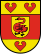 Coat of arms | |
 | |
| Country | Germany |
| State | North Rhine-Westphalia |
| Adm. region | Münster |
| Capital | Steinfurt |
| Government | |
| • District admin. | Dr. Klaus Effing (CDU) |
| Area | |
| • Total | 1,792.097 km2 (691.933 sq mi) |
| Population (31 December 2020)[1] | |
| • Total | 448,197 |
| • Density | 250/km2 (650/sq mi) |
| Time zone | UTC+01:00 (CET) |
| • Summer (DST) | UTC+02:00 (CEST) |
| Vehicle registration | ST, TE, BF |
| Website | http://www.kreis-steinfurt.de |
Geography
The district is situated at the Lower Saxon border, north of Münster. The Ems river runs through the district from south to north. The highest point in the region is the Westerbecker Berg at 234 metres above sea level; the lowest point is Bentlage Castle at 32 metres.
History
In the middle ages and early modern period, Steinfurt was an independent county of the Holy Roman Empire. In 1806, it became part of the Grand Dutchy of Berg and in 1815 it became part of the Kingdom of Prussia.
In 1975, the old district Steinfurt was merged with the district Tecklenburg, and together with Greven and Saerbeck from the former district Münster the current district was formed.
Coat of arms
The coat of arms combines elements from the coats of arms of the former districts of Steinfurt, Tecklenburg and Münster. The swan in the middle comes from the countship of Steinfurt, the centre of the district. The red bar around the swan symbolizes the clerical state of Münster, which lay around the dukedom of Steinfurt. The red water lily leaves were symbols of the dukes of Tecklenburg.
Towns and municipalities

| Towns | Municipalities | |
|---|---|---|
Town Twinning
Steinfurt is twinned with:
References
- "Bevölkerung der Gemeinden Nordrhein-Westfalens am 31. Dezember 2020" (in German). Landesbetrieb Information und Technik NRW. Retrieved 21 June 2021.
- Ealing Council.Twinning. Accessed 2008-09-19
External links
![]() Media related to Kreis Steinfurt at Wikimedia Commons
Media related to Kreis Steinfurt at Wikimedia Commons
| Urban districts |  | |
|---|---|---|
| Rural districts |
| |
Districts of German states (Full list)
| ||
Authority control | |
|---|---|
| General | |
| National libraries | |
На других языках
[de] Kreis Steinfurt
Der Kreis Steinfurt ist eine Gebietskörperschaft im Norden von Nordrhein-Westfalen (Deutschland). Er entstand am 1. Januar 1975 im Zuge der Kreisgebietsreform durch das Münster/Hamm-Gesetz aus dem alten Kreis Steinfurt, dem Kreis Tecklenburg und Teilen des Kreises Münster. Um eine Differenzierung zum Altkreis zu schaffen, wird er häufig auch als Großkreis Steinfurt bezeichnet. Die größte Stadt im Kreis Steinfurt ist Rheine.- [en] Steinfurt (district)
[ru] Штайнфурт (район)
Штайнфурт (нем. Steinfurt) — район в Германии. Центр района — город Штайнфурт. Район входит в землю Северный Рейн-Вестфалия. Подчинён административному округу Мюнстер. Занимает площадь 1792 км². Население — 443,4 тыс. чел. (2010). Плотность населения — 247 человек/км². Официальный код района — 05 5 66.Другой контент может иметь иную лицензию. Перед использованием материалов сайта WikiSort.org внимательно изучите правила лицензирования конкретных элементов наполнения сайта.
WikiSort.org - проект по пересортировке и дополнению контента Википедии