world.wikisort.org - Germany
Soest (German: [ˈzoːst] (![]() listen)) is a Kreis (district) in the middle of North Rhine-Westphalia, Germany. Neighbouring districts are Warendorf, Gütersloh, Paderborn, Hochsauerland, Märkischer Kreis, Unna and the independent town of Hamm.
listen)) is a Kreis (district) in the middle of North Rhine-Westphalia, Germany. Neighbouring districts are Warendorf, Gütersloh, Paderborn, Hochsauerland, Märkischer Kreis, Unna and the independent town of Hamm.
Kreis Soest | |
|---|---|
District | |
 Flag 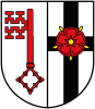 Coat of arms | |
 | |
| Country | Germany |
| State | North Rhine-Westphalia |
| Adm. region | Arnsberg |
| Capital | Soest |
| Area | |
| • Total | 1,327.47 km2 (512.54 sq mi) |
| Population (31 December 2020)[1] | |
| • Total | 301,016 |
| • Density | 230/km2 (590/sq mi) |
| Time zone | UTC+01:00 (CET) |
| • Summer (DST) | UTC+02:00 (CEST) |
| Vehicle registration | SO, LP |
| Website | http://www.kreis-soest.de |
History
In medieval times Soest was the biggest town in Westphalia; however, after it liberated itself from the bishops of Cologne in the Soester Fehde in 1449 it slowly lost importance, only to gain it again when in 1816 the new Prussian government created the district. In 1975 the district was merged with the neighbouring district of Lippstadt and parts of the former district of Arnsberg.
Geography
Geographically it covers the northern part of the Sauerland hills and the lower land north of it, the 'Hellweg'. The rather flat land and very fertile loess soil have made it an agricultural area from ancient times. The main rivers through the district are the Ruhr, the Lippe and the Möhne, which is dammed to form the Möhne Reservoir. The highest elevation is in the area of Warstein at 580m, while the lowest is the Lippe valley at 65m.
Coat of arms
The coat of arms show two symbols of the bishops of Cologne, who possessed Soest until 1449. In left half is the key of Saint Peter, the patron of Cologne; in the right is the black cross of Cologne. After the district was merged with Lippstadt the rose, symbol of the Lippe area, was added on top of the cross. This new version of the coat of arms was granted in 1976.
Towns and municipalities

| Towns | Municipalities |
|---|---|
References
- "Bevölkerung der Gemeinden Nordrhein-Westfalens am 31. Dezember 2020" (in German). Landesbetrieb Information und Technik NRW. Retrieved 21 June 2021.
External links
![]() Media related to Kreis Soest at Wikimedia Commons
Media related to Kreis Soest at Wikimedia Commons
- Official website (German, English)
| Urban districts |  | |
|---|---|---|
| Rural districts |
| |
Districts of German states (Full list)
| ||
This Soest district location article is a stub. You can help Wikipedia by expanding it. |
На других языках
[de] Kreis Soest
Der Kreis Soest [.mw-parser-output .IPA a{text-decoration:none}zoːst] ist ein Kreis in der östlichen Mitte von Nordrhein-Westfalen im Regierungsbezirk Arnsberg. Er entstand am 1. Januar 1975 aus dem damaligen Kreis Soest und dem ehemaligen Kreis Lippstadt sowie dem ehemaligen Amt Warstein aus dem früheren Kreis Arnsberg und einzelnen Gemeinden anderer Kreise.- [en] Soest (district)
[ru] Зост (район)
Зост (нем. Soest) — район в Германии. Центр района — город Зост. Район входит в землю Северный Рейн-Вестфалия. Подчинён административному округу Арнсберг. Занимает площадь 1328 км². Население — 304,9 тыс. чел. (2010). Плотность населения — 230 человек/км². Официальный код района — 05 9 74.Другой контент может иметь иную лицензию. Перед использованием материалов сайта WikiSort.org внимательно изучите правила лицензирования конкретных элементов наполнения сайта.
WikiSort.org - проект по пересортировке и дополнению контента Википедии