world.wikisort.org - Germany
Euskirchen (German pronunciation: [ˈɔʏskɪʁçn̩] (![]() listen)) is a Kreis (district) in the south-west of North Rhine-Westphalia, Germany. Neighboring districts are Aachen, Düren, Rhein-Erft-Kreis, Rhein-Sieg, Ahrweiler, Daun, Bitburg-Prüm, and the Liège province (Belgium).
listen)) is a Kreis (district) in the south-west of North Rhine-Westphalia, Germany. Neighboring districts are Aachen, Düren, Rhein-Erft-Kreis, Rhein-Sieg, Ahrweiler, Daun, Bitburg-Prüm, and the Liège province (Belgium).
Euskirchen | |
|---|---|
District | |
 Flag  Coat of arms | |
 | |
| Country | Germany |
| State | North Rhine-Westphalia |
| Adm. region | Cologne |
| Capital | Euskirchen |
| Area | |
| • Total | 1,249.093 km2 (482.278 sq mi) |
| Population (31 December 2020)[1] | |
| • Total | 194,359 |
| • Density | 160/km2 (400/sq mi) |
| Time zone | UTC+01:00 (CET) |
| • Summer (DST) | UTC+02:00 (CEST) |
| Vehicle registration | EU, SLE |
| Website | http://www.kreis-euskirchen.de |
History
In 1827 a first district around the city of Euskirchen was created, however much smaller than today. In 1932 the district of Rheinbach was dissolved, whereby the Euskirchen district gained its southern part. In 1972 the Euskirchen district grew again by the inclusion of the Schleiden district.
Geography
Geographically, the south-western half of the district is inside the Eifel hill chain. This land is hardly suitable for agriculture, and therefore in historical times the region was rather poor. Areas further to the north-east are more flat and have historically been used to grow a variety of crops, most notably sugar beets. The only other source of wealth was the iron ore, but today the many forests there make the area interesting for tourists.
Coat of arms
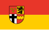
The coat of arms shows the four signs of the main historical territories or rulers of the district. Top-left are the roses of the counts of Arenberg, top-right the lion of Jülich, bottom-right the wave-line of the counts of Manderscheid-Blankenheim, and bottom-left the Cologne cross. The coat of arms was granted in 1973.
Towns and municipalities

| Towns | Municipalities |
|---|---|
|
|
References
- "Bevölkerung der Gemeinden Nordrhein-Westfalens am 31. Dezember 2020" (in German). Landesbetrieb Information und Technik NRW. Retrieved 21 June 2021.
External links
![]() Media related to Kreis Euskirchen at Wikimedia Commons
Media related to Kreis Euskirchen at Wikimedia Commons
- Official Website (German)
| Urban districts |  | |
|---|---|---|
| Rural districts |
| |
Districts of German states (Full list)
| ||
Authority control | |
|---|---|
| General | |
| National libraries | |
На других языках
[de] Kreis Euskirchen
Der Kreis Euskirchen ist eine Gebietskörperschaft im äußersten Südwesten des Landes Nordrhein-Westfalen mit 194.701 Einwohnern (31. Dezember 2021). Verwaltungssitz ist die namensgebende Kreisstadt Euskirchen.- [en] Euskirchen (district)
[ru] Ойскирхен (район)
Ойскирхен (нем. Euskirchen) — район в Германии. Центр района — город Ойскирхен. Район входит в землю Северный Рейн-Вестфалия. Подчинён административному округу Кёльн. Занимает площадь 1249 км². Население — 191,6 тыс. человек (2010). Плотность населения — 153 человек/км². Официальный код района — 05 3 66.Другой контент может иметь иную лицензию. Перед использованием материалов сайта WikiSort.org внимательно изучите правила лицензирования конкретных элементов наполнения сайта.
WikiSort.org - проект по пересортировке и дополнению контента Википедии