world.wikisort.org - Germany
Bad Münstereifel (German pronunciation: [ˈbaːt mʏnstɐˈʔaɪ̯fl̩] (![]() listen)) is a historical spa town in the district of Euskirchen, Germany, with about 17,000 inhabitants, situated in the far southwest of the German state of North Rhine-Westphalia. The little town is one of only a few historical towns in the southwest of North Rhine-Westphalia, and because of this is often overcrowded by tourists throughout spring and summer.
listen)) is a historical spa town in the district of Euskirchen, Germany, with about 17,000 inhabitants, situated in the far southwest of the German state of North Rhine-Westphalia. The little town is one of only a few historical towns in the southwest of North Rhine-Westphalia, and because of this is often overcrowded by tourists throughout spring and summer.
Bad Münstereifel | |
|---|---|
Town | |
 | |
 Flag Coat of arms | |
Location of Bad Münstereifel within Euskirchen district  | |
 Bad Münstereifel  Bad Münstereifel | |
| Coordinates: 50°33′11″N 06°45′58″E | |
| Country | Germany |
| State | North Rhine-Westphalia |
| Admin. region | Köln |
| District | Euskirchen |
| Government | |
| • Mayor (2020–25) | Sabine Preiser-Marian[1] (CDU) |
| Area | |
| • Total | 150.84 km2 (58.24 sq mi) |
| Elevation | 434 m (1,424 ft) |
| Population (2020-12-31)[2] | |
| • Total | 17,387 |
| • Density | 120/km2 (300/sq mi) |
| Time zone | UTC+01:00 (CET) |
| • Summer (DST) | UTC+02:00 (CEST) |
| Postal codes | 53902 |
| Dialling codes | 02253, 02257 |
| Vehicle registration | EU, SLE |
| Website | www.bad-muenstereifel.de |


Geography
Location
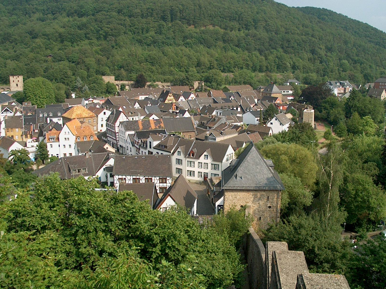

Bad Münstereifel lies about 30 kilometres (19 mi) southwest of Bonn and around ten (both as the crow flies) south of the county town of Euskirchen in the Münstereifel Forest, a part of the Eifel mountains. The River Erft flow through the town. It has a borough of around 151 km2 (58 sq mi) in area at heights of 200 to 586.1 m (656 to 1,923 ft) above sea level.[3] The latter is the height of the Michelsberg, which is the highest point in the borough and rises in the northwestern part of the Ahr Hills (another region of the Eifel).
The borough is around 60 percent forested, several woods are designated as so-called ancient forest (Urwald). Over 200 km (120 mi) of trails enable access to the low mountain uplands, which are about 25 km (16 mi) from the Eifel National Park.

Subdivisions
Arloff, Bergrath, Berresheim, Effelsberg, Eichen, Eicherscheid, Ellesheim, Esch, Eschweiler, Gilsdorf, Hilterscheid, Hohn, Holzem, Honerath, Houverath, Hummerzheim, Hünkhoven, Iversheim, Kalkar, Bad Münstereifel, Kirspenich, Kolvenbach, Kop Nück, Langscheid, Lanzerath, Lethert, Limbach, Lingscheiderhof, Mahlberg, Maulbach, Mutscheid, Neichen, Nitterscheid, Nöthen, Odesheim, Ohlerath, Reckerscheid, Rodert, Rupperath, Sasserath, Scheuerheck, Scheuren, Schönau, Soller, Vollmert, Wald, Willerscheid, Witscheiderhof
Education
Bad Münstereifel is the seat of SIGNO innovation society Eifel Association, Association of the greatest inventors in Germany. Signo is a project of the Federal Ministry of Economics and Technology. Joined the Association is a youth and children's department, may acquire in the children and young people in a club's workshop, the basic knowledge of technology.[4]
Bad Münstereifel has four elementary schools in the main town as well as the subdistricts of Arloff, Mutscheid, and Houverath. A Hauptschule and Realschule share facilities, while the city has two Gymnasium: the public St. Michael-Gymnasium and the diocesan-run St.-Angela-Gymnasium. Furthermore, the Apostolic school of the Legionaries of Christ has its seat in the city.
Since 1976, the city is also home to the University of Applied Sciences for the Administration of Justice of North Rhine-Westphalia. There are also several private training facilities in the city, including the Kurt-Schumacher-Academy of the Friedrich-Ebert-Stiftung and the House of Labor Security of the Trade Association for Electrical and Precision Engineering.[5] There is also a house of the Youth Red Cross as an educational facility for the National Association (North Division).
Bad Münstereifel has a public library with a stock of 16,000 media.[6]
Local council
The local council has 32 seats, the elections were held in May 2014.
- CDU: 12 seats
- SPD: 8 seats
- FDP: 4 seats
- UWV: 4 seats
- Alliance 90/The Greens: 3 seats
- The Left: 1 seat
Notable people and gatherings
- Heino (born 1938), the folk-singer has lived in the town. From 1996 to 2012 he operated a cafe there.
- Friedrich Joseph Haass, (1780–1853), the "holy doctor of Moscow", was born in Bad Münstereifel.
- Wilhelm Mohr (1838-1888), German journalist
- Christopher Becker (born 1980), German film director, screenwriter and film producer
The unofficial Nintendo fan convention, NCON, was held in the town's St.-Angela-Gymnasium in the early years of the 21st century.
The Portuguese Socialist Party, one of the two main Portuguese parties, was founded here in 1973 with the guidance of the Social Democratic Party of Germany, who wanted to create a political force capable of keeping Portugal a member of NATO.[7]
Other personalities associated with the town
- Otto Graf Lambsdorff (1926–2009), politician, former Bundesminister für Wirtschaft (Minister of Economic Affairs) and chairman of the FDP, lived in the district of Eschweiler.
International relations
Bad Münstereifel is twinned with:
 Ashford, United Kingdom
 Fougères, France.
See also
- Alte Burg (Bad Münstereifel) – the site of an old refuge castle
- Effelsberg 100-m Radio Telescope
References
- Wahlergebnisse in NRW Kommunalwahlen 2020, Land Nordrhein-Westfalen, accessed 19 June 2021.
- "Bevölkerung der Gemeinden Nordrhein-Westfalens am 31. Dezember 2020" (in German). Landesbetrieb Information und Technik NRW. Retrieved 21 June 2021.
- "Zahlen & Fakten". bad-muenstereifel.de (in German). Stadt Bad Münstereifel. Retrieved 2015-01-29.
- Innovations-Gesellschaft Eifel e.V. – Willkommen
- Stadt Bad Münstereifel
- Stadt Bad Münstereifel
- SONER ÇAĞAPTAY – Portuguese Lessons for Turkey’s Role in the Arab Spring
External links
Towns and municipalities in Euskirchen (district) | ||
|---|---|---|
 | ||
Borough of Bad Münstereifel | ||
|---|---|---|
| ||
Authority control | |
|---|---|
| General | |
| National libraries | |
| Other |
|
На других языках
- [en] Bad Münstereifel
[es] Bad Münstereifel
Bad Münstereifel es un municipio situado en el distrito de Euskirchen, en el estado federado de Renania del Norte-Westfalia (Alemania), con una población a finales de 2016 de unos 17 291 habitantes.[2][ru] Бад-Мюнстерайфель
Бад-Мюнстерайфель (нем. Bad Münstereifel) — город в Германии, в земле Северный Рейн-Вестфалия.Другой контент может иметь иную лицензию. Перед использованием материалов сайта WikiSort.org внимательно изучите правила лицензирования конкретных элементов наполнения сайта.
WikiSort.org - проект по пересортировке и дополнению контента Википедии