world.wikisort.org - Germany
Laer (German pronunciation: [ˈlaːɐ̯]) is a municipality in the district of Steinfurt, in North Rhine-Westphalia, Germany. It is situated approximately 10 kilometres (6.2 mi) south of Steinfurt and 20 kilometres (12 mi) north-west of Münster.
This article needs additional citations for verification. (April 2009) |
Laer | |
|---|---|
Municipality | |
 Laer, church (Pfarrkirche Sankt Bartholomäus) | |
 Coat of arms | |
Location of Laer within Steinfurt district 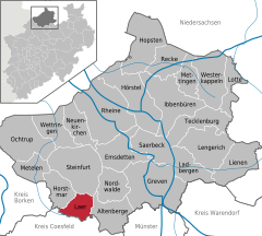 | |
 Laer  Laer | |
| Coordinates: 52°03′17″N 7°21′25″E | |
| Country | Germany |
| State | North Rhine-Westphalia |
| Admin. region | Münster |
| District | Steinfurt |
| First mentioned | 1134 |
| Government | |
| • Mayor (2020–25) | Manfred Kluthe[1] (CDU) |
| Area | |
| • Total | 35.25 km2 (13.61 sq mi) |
| Elevation | 77 m (253 ft) |
| Population (2020-12-31)[2] | |
| • Total | 6,700 |
| • Density | 190/km2 (490/sq mi) |
| Time zone | UTC+01:00 (CET) |
| • Summer (DST) | UTC+02:00 (CEST) |
| Postal codes | 48366 |
| Dialling codes | 02554 |
| Vehicle registration | ST |
| Website | www |
Since the ae spelling already contradicted the rules in force before 1996, it was not amended in accordance with a recommendation of the Standing Committee on Geographical Names.[3]
Gallery
 Laer, chapel in the street
 Holthausen, church (Pfarrkirche Sankt Marien)
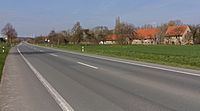 Altenburg, street view from local road


References
- Wahlergebnisse in NRW Kommunalwahlen 2020, Land Nordrhein-Westfalen, accessed 30 June 2021.
- "Bevölkerung der Gemeinden Nordrhein-Westfalens am 31. Dezember 2020" (in German). Landesbetrieb Information und Technik NRW. Retrieved 21 June 2021.
- "StAGN Web - Homepage - Empfehlung zur Anwendung der Rechtschreibreform".
Towns and municipalities in Steinfurt (district) | ||
|---|---|---|
 | ||
This Steinfurt district location article is a stub. You can help Wikipedia by expanding it. |
На других языках
[de] Laer
Laer (gesprochen [.mw-parser-output .IPA a{text-decoration:none}laːr] mit Dehnungs-e, plattdeutsch Laor) ist eine Gemeinde im Kreis Steinfurt im Norden Nordrhein-Westfalens.- [en] Laer
[es] Laer
Laer es un municipio situado en el distrito de Steinfurt, en el estado federado de Renania del Norte-Westfalia (Alemania), con una población a finales de 2016 de unos 6745 habitantes.[2][ru] Лар (Штайнфурт)
Лар (нем. Laer) — община в Германии, в земле Северный Рейн-Вестфалия.Текст в блоке "Читать" взят с сайта "Википедия" и доступен по лицензии Creative Commons Attribution-ShareAlike; в отдельных случаях могут действовать дополнительные условия.
Другой контент может иметь иную лицензию. Перед использованием материалов сайта WikiSort.org внимательно изучите правила лицензирования конкретных элементов наполнения сайта.
Другой контент может иметь иную лицензию. Перед использованием материалов сайта WikiSort.org внимательно изучите правила лицензирования конкретных элементов наполнения сайта.
2019-2026
WikiSort.org - проект по пересортировке и дополнению контента Википедии
WikiSort.org - проект по пересортировке и дополнению контента Википедии