world.wikisort.org - France
Port-en-Bessin-Huppain (French pronunciation: [pɔʁ ɑ̃ bɛsɛ̃ ypɛ̃] (![]() listen)) is a commune in the Calvados department in the Normandy region in northwestern France.
listen)) is a commune in the Calvados department in the Normandy region in northwestern France.
This article may be expanded with text translated from the corresponding article in French. (December 2008) Click [show] for important translation instructions.
|
Port-en-Bessin-Huppain | |
|---|---|
Commune | |
 Port-en-Bessin-Huppain, seen from above the Vauban Tower | |
 Coat of arms | |
Location of Port-en-Bessin-Huppain  | |
 Port-en-Bessin-Huppain  Port-en-Bessin-Huppain | |
| Coordinates: 49°20′42″N 0°45′14″W | |
| Country | France |
| Region | Normandy |
| Department | Calvados |
| Arrondissement | Bayeux |
| Canton | Bayeux |
| Government | |
| • Mayor (2020–2026) | Christophe Van Roye |
| Area 1 | 7.56 km2 (2.92 sq mi) |
| Population | 1,938 |
| • Density | 260/km2 (660/sq mi) |
| Time zone | UTC+01:00 (CET) |
| • Summer (DST) | UTC+02:00 (CEST) |
| INSEE/Postal code | 14515 /14520 |
| Elevation | 0–74 m (0–243 ft) (avg. 50 m or 160 ft) |
| 1 French Land Register data, which excludes lakes, ponds, glaciers > 1 km2 (0.386 sq mi or 247 acres) and river estuaries. | |
The commune contains the two towns of Port-en-Bessin and Huppain.
Population
|
|
History
The name Huppain stems from Norse/Norwegian Oppheim, reflecting the general Viking history of Normandy.
The town was captured by Royal Marines of No. 47 (Royal Marine) Commando in Operation Aubery during the Normandy landings and used as the terminal for PLUTO (Pipe-Lines Under The Ocean).[2]
Media

Port-en-Bessin was used to represent nearby Ouistreham in the 1962 film The Longest Day.[3]
Sister cities
 Saint-Pierre, Saint Pierre and Miquelon, (France), since 1976.[4]
See also
Gallery
- Château de Villiers-sur-Port
- Église Saint-Nicolas de Villiers-sur-Port
- Bridge and port of Port-en-Bessin-Huppain, by Georges Seurat, 1888
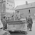
- General Montgomery with Army and Royal Navy officers in Port-en-Bessin, 10 June 1944 in the Normandy Campaign
References
- "Populations légales 2019". The National Institute of Statistics and Economic Studies. 29 December 2021.
- "D-Day: Heroic battle in Port-en-Bessin". Daily Telegraph. Retrieved 29 December 2013.
- Notre jour le plus long La Presse de la Manche 2012
- Jumelages
| Wikimedia Commons has media related to Port-en-Bessin-Huppain. |
На других языках
- [en] Port-en-Bessin-Huppain
[ru] Пор-ан-Бессен-Юппен
Пор-ан-Бессе́н-Юппе́н (фр. Port-en-Bessin-Huppain) — коммуна во Франции, находится в регионе Нижняя Нормандия. Департамент коммуны — Кальвадос. Входит в состав кантона Ри. Округ коммуны — Байё.Текст в блоке "Читать" взят с сайта "Википедия" и доступен по лицензии Creative Commons Attribution-ShareAlike; в отдельных случаях могут действовать дополнительные условия.
Другой контент может иметь иную лицензию. Перед использованием материалов сайта WikiSort.org внимательно изучите правила лицензирования конкретных элементов наполнения сайта.
Другой контент может иметь иную лицензию. Перед использованием материалов сайта WikiSort.org внимательно изучите правила лицензирования конкретных элементов наполнения сайта.
2019-2025
WikiSort.org - проект по пересортировке и дополнению контента Википедии
WikiSort.org - проект по пересортировке и дополнению контента Википедии


