world.wikisort.org - France
Argences (French pronunciation: [aʁʒɑ̃s] (![]() listen)) is a commune in the Calvados department in the Normandy region of north-western France. It is in the urban area of Caen, 15 kilometres from the city.
listen)) is a commune in the Calvados department in the Normandy region of north-western France. It is in the urban area of Caen, 15 kilometres from the city.
Argences | |
|---|---|
Commune | |
 General view of Argences | |
 Coat of arms | |
Location of Argences  | |
 Argences  Argences | |
| Coordinates: 49°07′37″N 0°09′59″W | |
| Country | France |
| Region | Normandy |
| Department | Calvados |
| Arrondissement | Caen |
| Canton | Troarn |
| Intercommunality | Val ès Dunes |
| Government | |
| • Mayor (2020–2026) | Dominique Delivet[1] |
| Area 1 | 9.76 km2 (3.77 sq mi) |
| Population | 3,795 |
| • Density | 390/km2 (1,000/sq mi) |
| Time zone | UTC+01:00 (CET) |
| • Summer (DST) | UTC+02:00 (CEST) |
| INSEE/Postal code | 14020 /14370 |
| Elevation | 2–74 m (6.6–242.8 ft) (avg. 44 m or 144 ft) |
| 1 French Land Register data, which excludes lakes, ponds, glaciers > 1 km2 (0.386 sq mi or 247 acres) and river estuaries. | |
The inhabitants of the commune are known as Argençais or Argençaises[3]
The commune has been awarded one flower by the National Council of Towns and Villages in Bloom in the Competition of cities and villages in Bloom.[4]
Geography
Argences is some 15 km south-east of Caen and 1 km north of Moult. Access to the commune is by the D37 road from Saint-Pair in the north passing through the commune and the town and continuing to Moult in the south. The D41 road goes east from the town to join the D613 to Caen at Vimont. The D80 road also goes north-east from the town to Saint-Pierre-du-Jonquet. Apart from the town there are also the hamlets of Le Fresne to the north, Le Mesnil in the north-east, and Le Croix de Moult south of the town. The commune consists of a large residential area in the town with a large forest in the north-east (the Bois de Saint-Gilles) with small scattered forests but mostly farmland.[5]
The Muane river flows through the town and the commune from south to north.
Neighbouring communes and villages | |
|---|---|
History
In 989 Richard I of Normandy donated land to the Abbey of Fécamp for the curates of Mondeville and Argences. From that date, the domain of Mondeville was managed as an ecclesiastical fief by the Barony of Argences. During the ducal era the wines of Argences were highly regarded.[6]
In 1912, the large tile factory at Fresne built a railway line 4 km long connecting Argences to Moult-Argences Station in Moult on the Paris-Cherbourg line. The line from Argences was closed in 1931 and the nearest station is now Moult-Argences (TER Basse-Normandie).
On 16 April 1942 a group of resistance fighters derailed a Maastricht-Cherbourg train two kilometres from Moult-Argences station in Airan commune causing 28 dead and 19 wounded - all German soldiers. On 30 April of that year, in revenge for German retaliation, a new derailment of the same train killed 10 German soldiers and wounded 22 others.[7]
Heraldry
 |
Blazon: Gules, 3 laurel branches Vert, 1 pale in chief, 2 stems in base saltirewise between 3 mitres of Or the fanons of the one in base debruised by the laurel leaves.
|
Administration
List of Successive Mayors[8]
| From | To | Name | Party | Position |
|---|---|---|---|---|
| 1790 | 1791 | Pierre Michel Gouget | ||
| 1791 | 1792 | André Pierre Duval-Destin | ||
| 1792 | 1794 | Robert Lesage | ||
| 1794 | 1795 | Nicolas Guillaume Moulin | ||
| 1795 | 1796 | Pierre Robert Caillouie | ||
| 1796 | 1797 | Joseph Bornet | ||
| 1797 | 1798 | Jean Mathieu Duport | ||
| 1798 | 1799 | Joseph Bornet | ||
| 1799 | 1799 | Nicolas Guillaume Moulin | ||
| 1799 | 1800 | André Halbique | ||
| 1800 | 1806 | Pierre Duval-Destin | ||
| 1806 | 1808 | Pierre Robert Cailloue | ||
| 1808 | 1812 | François Huillard | ||
| 1812 | 1815 | Ferdinand Desessarts | ||
| 1815 | 1826 | Nicolas Moulin | ||
| 1826 | 1828 | Jean Baptiste Honore | ||
| 1828 | 1830 | Jean Duport | ||
| 1830 | 1840 | Modeste Ancelle | ||
| 1840 | 1841 | Germain Lecharpertier | ||
| 1841 | 1843 | Jean Doublet | ||
| 1843 | 1859 | Modeste Ancelle | ||
| 1859 | 1871 | Armand Laville | ||
| 1871 | 1874 | Germain Lecharpertier | ||
| 1874 | 1874 | Armand Laville | ||
| 1874 | 1896 | Dominique Lecomte | ||
| 1896 | 1908 | Joseph Dalgot | ||
| 1908 | 1912 | Désiré Lepetit | ||
| 1912 | 1921 | André Gourmez | ||
| 1921 | 1929 | Clément Michel |
- Mayors from 1929
| From | To | Name | Party | Position |
|---|---|---|---|---|
| 1929 | 1945 | Jean Hamel | ||
| 1945 | 1947 | Albert Frilley | ||
| 1947 | 1953 | Jean Hamel | ||
| 1953 | 1954 | René Maginier | ||
| 1954 | 1965 | André Plantain | ||
| 1965 | 1970 | Michel Jourdan | ||
| 1970 | 1971 | Georges Lemesle | ||
| 1971 | 1979 | Alfred Rouillard | ||
| 1979 | 1989 | Gilbert Deru | ||
| 1989 | 1995 | Jean-François Hamel | ||
| 1995 | 2001 | Gilbert Deru | ||
| 2001 | 2008 | Bernard Dufour | Retired ETF officer | |
| 2008 | 2026 | Dominique Delivet | LREM | Headmaster |
Population
| Year | Pop. | ±% p.a. |
|---|---|---|
| 1968 | 1,802 | — |
| 1975 | 2,215 | +2.99% |
| 1982 | 3,000 | +4.43% |
| 1990 | 3,048 | +0.20% |
| 1999 | 3,241 | +0.68% |
| 2007 | 3,495 | +0.95% |
| 2012 | 3,596 | +0.57% |
| 2017 | 3,718 | +0.67% |
| Source: INSEE[9] | ||
Economy
The newspaper L'Echo de la Muance was published in Argences from 1896 to 1897.[10]
Sites and monuments
- The Chateau of Fresne (1651)
 is registered as an historical monument.[11]
 - The Church of Saint-Jean was destroyed by bombing in 1944 and only the wall of the apse remains.
- The Moulin de la Porte (Mill of the door) where the wheel is powered by the Muance.
- The Lavoir (Public laundry) in the Rue de la Morte eau.
- The old Tuileries de Beauvais tile factory.
Argences picture gallery
 General view of Argences
 General Leclerc Square and the church
 The Moulin de la Porte
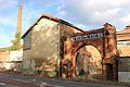 The entrance to the Tuileries de Beauvais


Activities and events
The association of rural families organizes dance classes for children and adults (beginners, modern dance, Fit'n dance).
Notable people linked to the commune
- Dominique Lemesle (1951-2007): Assistant Football Referee - 1st French Division (1979-1982)
- François Fayt (1946-): composer.
- Yohann Eudeline (1982-), French footballer who played at the local football club until 2000.
See also
References
- "Répertoire national des élus: les maires". data.gouv.fr, Plateforme ouverte des données publiques françaises (in French). 2 December 2020.
- "Populations légales 2019". The National Institute of Statistics and Economic Studies. 29 December 2021.
- Inhabitants of Calvados (in French)
- Argences in the Competition for Towns and Villages in Bloom Archived December 10, 2014, at the Wayback Machine (in French)
- Google Maps
- Jean Renaud, The Vikings and Normandy, éditions Ouest-France université, 1989. (in French)
- The double derailment at Moult-Argences and the hostages of Calvados, Claudine Cardon-Hamet (in French)
- List of Mayors of France (in French)
- Population en historique depuis 1968, INSEE
- Jean Quellien et Christophe Mauboussin, Newspapers from 1786 to 1944, the adventure of the press in Basse-Normandie, Cahiers du Temps, 1998. ISBN 2911855132 (in French)
- Ministry of Culture, Mérimée PA00111015 Chateau of Fresne (in French)

External links
Authority control | |
|---|---|
| General |
|
| National libraries | |
На других языках
[de] Argences
Argences ist eine französische Gemeinde mit 3.795 Einwohnern (Stand: 1. Januar 2019) im Département Calvados in der Region Normandie; sie gehört zum Arrondissement Caen und zum Kanton Troarn. Die Einwohner werden Argençais genannt.- [en] Argences
[ru] Аржанс (коммуна)
Аржа́нс (фр. Argences) — коммуна во Франции, находится в регионе Нормандия, департамент Кальвадос, округ Кан, кантон Троарн. Расположена в 14 км к юго-востоку от Кана, в 10 км от автомагистрали А13 "Нормандия". Через территорию коммуны протекает река Мюанс.Другой контент может иметь иную лицензию. Перед использованием материалов сайта WikiSort.org внимательно изучите правила лицензирования конкретных элементов наполнения сайта.
WikiSort.org - проект по пересортировке и дополнению контента Википедии