world.wikisort.org - France
Authie (French: [oti] (![]() listen)) is a commune in the Calvados department in the Normandy region of north-western France.
listen)) is a commune in the Calvados department in the Normandy region of north-western France.
Authie | |
|---|---|
Commune | |
 Authie Town Hall | |
Location of Authie  | |
 Authie  Authie | |
| Coordinates: 49°12′24″N 0°25′50″W | |
| Country | France |
| Region | Normandy |
| Department | Calvados |
| Arrondissement | Caen |
| Canton | Caen-2 |
| Intercommunality | CU Caen Mer |
| Government | |
| • Mayor (2020–2026) | Olivier Simar |
| Area 1 | 3.21 km2 (1.24 sq mi) |
| Population | 1,696 |
| • Density | 530/km2 (1,400/sq mi) |
| Time zone | UTC+01:00 (CET) |
| • Summer (DST) | UTC+02:00 (CEST) |
| INSEE/Postal code | 14030 /14280 |
| Elevation | 60–73 m (197–240 ft) (avg. 65 m or 213 ft) |
| 1 French Land Register data, which excludes lakes, ponds, glaciers > 1 km2 (0.386 sq mi or 247 acres) and river estuaries. | |
The inhabitants of the commune are known as Althavillais or Althavillaises.[2]
The commune has been awarded one flower by the National Council of Towns and Villages in Bloom in the Competition of cities and villages in Bloom.[3]
Geography
Authie is located some 6 km (4 mi) north-west of the centre of Caen. Access to the commune is by road D220 from Villons-les-Buissons in the north-east which passes through the centre of the commune and the village and continues to Carpiquet in the south. The D220C also goes south-east from the village to the urban area of Caen. There are also the hamlets of Hameau de Saint-Louet, Franqueville, Fermie du Calvaire, and Cussy in the commune. Apart from the large residential area the commune is entirely farmland.[4]
Toponymy
The name of the town is attested in the forms Alteium in 1227 and Auteya in 1264.[5]
Albert Dauzat matched Authie with Authie in Somme department (Altegiam 830) on the coastal river Authie (Alteia 723) and considers it primarily as a hydronym but does not provide any further explanation.[6]
According to René Lepelley this toponym is based on the pre-Celtic element alt in an unknown sense and is close to Authou in Pont-Authou.[7]
François de Beaurepaire sees a Gallic (Celtic) element in the alt in Authou.[8]
The Gallic term Attegia was recognized by Xavier Delamarre in Atheist-type names - e.g. Athis in the sense of "cabin or hut".[9]
This analyses to ad- (pre-verb) and tegia meaning "house" (cf. Old Irish teg, old Welsh tig, Welsh Ty, Old Breton tig, and Breton ti all meaning "house").[10]
It is likely that Authie contains the same element tegia preceded by another prefix. From a phonetic point of view there is a palatalization of the intervocalic consonant where [g] becomes [j] and then an Amuïssement or attenuation of [j]>[∅], a recurrent phenomenon in phonetics.
The same author explains that Arthies (Artegiae 680) may come from *Are-tegia which is a possible solution for Authie, knowing that [r] regularly becomes [l] before a consonant.
The name Altavilla is either a medieval romanization of a place named Hauteville as in Hauteville in Manche department and therefore does not relate to Authie. It may be a scribal error for *Alteia Villa or *Villa Alteia which mentions a villa, i.e. a rural area in medieval Latin, in a place called Alteia which is Authie.
History
In 1832 Authie (466 inhabitants in 1831) absorbed Saint-Louet-près-Authie (9 people)[11] in the west of its territory.
The commune was liberated on 8 June 1944 but was largely destroyed in the bombing.
Administration
This list is incomplete; you can help by adding missing items. (April 2021) |
List of Successive Mayors[12]
| From | To | Name |
|---|---|---|
| 1983 | 2020 | Joël Pizy |
| 2020 | 2026 | Olivier Simar |
Twinning
Authie has twinning associations with:[13]
 North Baddesley (United Kingdom) since 1993.
Demography
In 2017 the commune had 1,595 inhabitants.
|
| ||||||||||||||||||||||||||||||||||||||||||||||||||||||||||||||||||||||||||||||||||||||||||||||||||||||||||||||||||
| Source: EHESS[14] and INSEE[15] | |||||||||||||||||||||||||||||||||||||||||||||||||||||||||||||||||||||||||||||||||||||||||||||||||||||||||||||||||||
Culture and heritage
Civil heritage
The commune has one site that is registered as an historical monument:
- An Ornamental Garden in the Château of Authie (18th century)
 [16]
[16] - The Monument to the Canadians dedicated to the victims of the taking of the village in 1944
Religious heritage

The commune has two religious buildings and structures that are registered as historical monuments:
The Church contains one item that is registered as an historical object:
- A Bronze Bell (1704)
 [19]
[19]
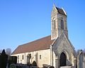 Saint Vigor church
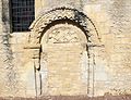 Saint-Vigor Portal
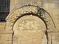 Detail on the Portal
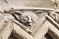 A detail on the church
 The Vault in the church
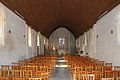 The Nave of the church
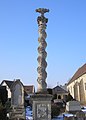 The Cemetery Cross


See also
External links
- Authie on Géoportail, National Geographic Institute (IGN) website (in French)
- Authie on the 1750 Cassini Map
References
- "Populations légales 2019". The National Institute of Statistics and Economic Studies. 29 December 2021.
- Inhabitants of Calvados (in French)
- Authie in the Competition for Towns and Villages in Bloom Archived December 10, 2014, at the Wayback Machine (in French)
- Google Maps
- Albert Dauzat and Charles Rostaing, Etymological Dictionary of place names in France, Librairie Guénégaud Paris 6th edition, 1979, p. 39a. (in French)
- Albert Dauzat and Charles Rostaing, op. cit.
- René Lepelley, Etymological Dictionary of commune names in Normandy, Charles Corlet éditions PUC 1994, p. 54b - 55a. ISBN 978-2-905461-80-3 (in French)
- The names of communes and old parishes in Eure, A. and J. Picard, François de Beaurepaire, preface by Marcel Baudot, 1981, Paris, 221 pages, ISBN 2-7084-0067-3, OCLC 9675154, p. 56 (in French)
- Xavier Delamarre, Dictionary of the Gallic language, éditions Errance 2003, p. 59. (in French)
- Xavier Delamarre, op. cit. (in French)
- Des villages de Cassini aux communes d'aujourd'hui: Commune data sheet Saint-Louet-près-Authie, EHESS. (in French)
- List of Mayors of France (in French)
- National Commission for Decentralised cooperation (in French)
- Des villages de Cassini aux communes d'aujourd'hui: Commune data sheet Authie, EHESS. (in French)
- Population en historique depuis 1968, INSEE
- Ministry of Culture, Mérimée IA80000395 Ornamental Garden in the Château of Authie (in French)
- Ministry of Culture, Mérimée PA00111024 Church of Saint Vigor (in French)

- Ministry of Culture, Mérimée PA00111023 Cemetery Cross (in French)
- Ministry of Culture, Palissy PM80000272 Bronze bell (in French)
На других языках
[de] Authie (Calvados)
Authie ist eine französische Gemeinde mit 1.696 Einwohnern (Stand: 1. Januar 2019) im Département Calvados in der Region Normandie. Die Gemeinde gehört zum Arrondissement Caen und zum Kanton Caen-2. Die Einwohner nennen sich Althavillais.- [en] Authie, Calvados
[ru] Оти (Кальвадос)
Оти́ (фр. Authie) — коммуна во Франции, находится в регионе Нижняя Нормандия. Департамент коммуны — Кальвадос. Входит в состав кантона Кан 2-й кантон. Округ коммуны — Кан.Другой контент может иметь иную лицензию. Перед использованием материалов сайта WikiSort.org внимательно изучите правила лицензирования конкретных элементов наполнения сайта.
WikiSort.org - проект по пересортировке и дополнению контента Википедии