world.wikisort.org - France
Gisors (French pronunciation: [ʒizɔʁ]) is a commune of Normandy, France. It is located 62.9 km (39.1 mi) northwest from the centre of Paris.
Gisors | |
|---|---|
Commune | |
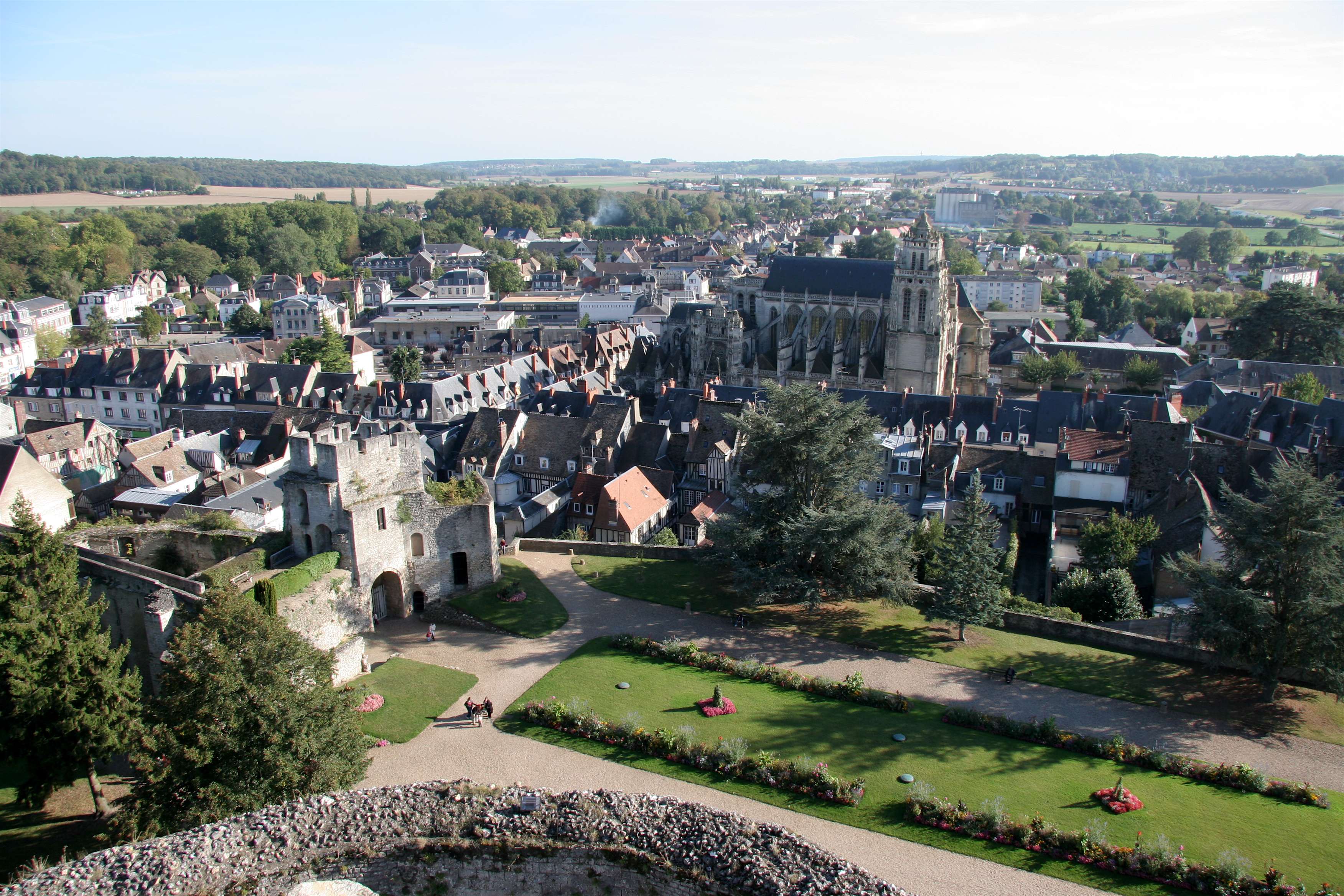 City as seen from the castle terrasse | |
 Coat of arms | |
Location of Gisors  | |
 Gisors  Gisors | |
| Coordinates: 49°16′52″N 1°46′38″E | |
| Country | France |
| Region | Normandy |
| Department | Eure |
| Arrondissement | Les Andelys |
| Canton | Gisors |
| Intercommunality | Vexin Normand |
| Government | |
| • Mayor (2020–2026) | Alexandre Rassaërt |
| Area 1 | 16.67 km2 (6.44 sq mi) |
| Population | 11,696 |
| • Density | 700/km2 (1,800/sq mi) |
| Time zone | UTC+01:00 (CET) |
| • Summer (DST) | UTC+02:00 (CEST) |
| INSEE/Postal code | 27284 /27140 |
| Elevation | 47–142 m (154–466 ft) (avg. 74 m or 243 ft) |
| 1 French Land Register data, which excludes lakes, ponds, glaciers > 1 km2 (0.386 sq mi or 247 acres) and river estuaries. | |
Gisors, together with the neighbouring communes of Trie-Château and Trie-la-Ville, form an urban area of 13,915 inhabitants (2018).[2] This urban area is a satellite town of Paris.
Geography
Gisors is located in the Vexin normand region of Normandy, at the confluence of the rivers Epte, Troesne and Réveillon.
Population
|
| ||||||||||||||||||||||||||||||||||||||||||||||||||||||||||||||||||||||||||||||||||||||||||||||||||||||||||||||||||
| Source: EHESS[3] and INSEE (1968-2017)[4] | |||||||||||||||||||||||||||||||||||||||||||||||||||||||||||||||||||||||||||||||||||||||||||||||||||||||||||||||||||
Transport
The Gisors station is the terminus of a Transilien suburban rail service from the Paris Saint-Lazare station, and of a TER Normandie local service to Serqueux.
Sights
- Château de Gisors, built in the 11th century.
- The Saint-Gervais-Saint-Protais parish church is an outstanding monument fusing Gothic and Renaissance architecture.
- A field near Gisors was the site of the Cutting of the elm, a medieval diplomatic incident.[5][6][7]
 Motte and Castle
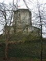 Castle of Gisors
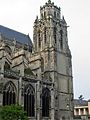 The so-called Grosse Tour ("Big Tower") of the St-Gervais-St-Protais church was built between 1542 and 1590.


See also
References
- "Populations légales 2019". The National Institute of Statistics and Economic Studies. 29 December 2021.
- Comparateur de territoire, INSEE
- Des villages de Cassini aux communes d'aujourd'hui: Commune data sheet Gisors, EHESS. (in French)
- Population en historique depuis 1968, INSEE
- Bradford Smith, The Foundations of the West - Course Material, Chapter 8 The Age of the Crusades - The Rise of France under Philip Augustus and of St. Louis Archived 2008-06-12 at the Wayback Machine Oglethorpe University, Summer 2000.
- Nicholas Vincent, "William Marshal, King Henry II and the Honour of Chateauroux Archived 2012-02-10 at the Wayback Machine", in: Archives: The Journal of the British Record Association vol. 25, no. 102 (2000).
- A Thirteenth-Century Minstrel's Chronicle, a translation by Robert Levine of the Récits d'un ménestrel de Reims, a thirteenth-century historical fiction Archived 2008-05-16 at the Wayback Machine, Mellen Press, Lewiston, 1990.
External links
Wikimedia Commons has media related to Gisors.
- Official site
- Gazetteer Entry
- . Encyclopædia Britannica (11th ed.). 1911.
Authority control | |
|---|---|
| General | |
| National libraries | |
| Other |
|
This Eure geographical article is a stub. You can help Wikipedia by expanding it. |
На других языках
- [en] Gisors
[ru] Жизор (Эр)
Жизор (фр. Gisors) — коммуна на севере Франции, регион Нормандия, департамент Эр, округ Лез-Андели, центр одноименного кантона. Расположена в 63 км к северо-западу от Парижа и в 61 км к юго-востоку от Руана, на берегу реки Эпт. В центре коммуны находится железнодорожная станция Жизор линии Сен-Дени―Дьеп.Текст в блоке "Читать" взят с сайта "Википедия" и доступен по лицензии Creative Commons Attribution-ShareAlike; в отдельных случаях могут действовать дополнительные условия.
Другой контент может иметь иную лицензию. Перед использованием материалов сайта WikiSort.org внимательно изучите правила лицензирования конкретных элементов наполнения сайта.
Другой контент может иметь иную лицензию. Перед использованием материалов сайта WikiSort.org внимательно изучите правила лицензирования конкретных элементов наполнения сайта.
2019-2026
WikiSort.org - проект по пересортировке и дополнению контента Википедии
WikiSort.org - проект по пересортировке и дополнению контента Википедии