world.wikisort.org - France
Cléguérec (French pronunciation: [kleɡeʁɛk]; Breton: Klegereg) is a commune in the Morbihan department of Brittany in north-western France.[3]
Cléguérec
Klegereg | |
|---|---|
Commune | |
 The parish church Saint Guérec. | |
 Coat of arms | |
Location of Cléguérec  | |
 Cléguérec  Cléguérec | |
| Coordinates: 48°07′30″N 3°04′10″W | |
| Country | France |
| Region | Brittany |
| Department | Morbihan |
| Arrondissement | Pontivy |
| Canton | Gourin |
| Intercommunality | Pontivy Communauté |
| Government | |
| • Mayor (2020–2026) | Marc Ropers[1] |
| Area 1 | 62.99 km2 (24.32 sq mi) |
| Population | 2,828 |
| • Density | 45/km2 (120/sq mi) |
| Time zone | UTC+01:00 (CET) |
| • Summer (DST) | UTC+02:00 (CEST) |
| INSEE/Postal code | 56041 /56480 |
| Elevation | 55–281 m (180–922 ft) |
| 1 French Land Register data, which excludes lakes, ponds, glaciers > 1 km2 (0.386 sq mi or 247 acres) and river estuaries. | |
Geography
The town is located 12 km (7.5 mi) northwest of Pontivy. Cléguérec is border by Séglien and Silfiac to the west, by Sainte-Brigitte and Saint-Aignan to the north, by Neulliac to the east and by Malguénac to the south. Historically, the town belongs to Vanetais. The forest of Quénécan extends to the north of the commune. The Breuil du Chêne is the highest hill in the town. The summit is 948 feet (289 m) above sea level.
Map

Demographics
Inhabitants of Cléguérec are called in French Cléguérecois.
|
| ||||||||||||||||||||||||||||||||||||||||||||||||||||||||||||||||||||||||||||||||||||||||||||||||||||||||||||||||||
| Source: EHESS[4] and INSEE (1968-2019)[5] | |||||||||||||||||||||||||||||||||||||||||||||||||||||||||||||||||||||||||||||||||||||||||||||||||||||||||||||||||||
Breton language
In 2008, 13,85% of children in the commune attended bilingual primary schools.[6]
Gallery
 Manor of Corbello
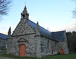 Chapel of Trinity
 Chapel Saint-André de Langlo
 Gallery grave of Bot-er-Mohed
 Calvary on the top of Breuil du Chêne


See also
- Communes of the Morbihan department
- Gaston-Auguste Schweitzer Sculptor of Cléguérec war memorial
References
- "Maires du Morbihan" (PDF). Préfecture du Morbihan. 7 July 2020.
- "Populations légales 2019". The National Institute of Statistics and Economic Studies. 29 December 2021.
- INSEE commune file
- Des villages de Cassini aux communes d'aujourd'hui: Commune data sheet Cléguérec, EHESS. (in French)
- , INSEE
- (in French) Ofis ar Brezhoneg: Enseignement bilingue
External links
- Official site (in French)
- Base Mérimée: Search for heritage in the commune, Ministère français de la Culture. (in French)
- Mayors of Morbihan Association (in French)
This Morbihan geographical article is a stub. You can help Wikipedia by expanding it. |
На других языках
[de] Cléguérec
Cléguérec (bretonisch: Klegereg) ist eine französische Gemeinde mit 2828 Einwohnern (Stand 1. Januar 2019) im Département Morbihan in der Region Bretagne. Sie gehört zum Gemeindeverband Pontivy Communauté.[1]- [en] Cléguérec
[fr] Cléguérec
Cléguérec [kleɡeʁɛk] est une commune française située dans le département du Morbihan, en région Bretagne. La petite ville est la capitale du pays Chistr'per, qui doit son nom à la production locale et artisanale de poiré, c'est-à-dire de cidre de poire.Другой контент может иметь иную лицензию. Перед использованием материалов сайта WikiSort.org внимательно изучите правила лицензирования конкретных элементов наполнения сайта.
WikiSort.org - проект по пересортировке и дополнению контента Википедии