world.wikisort.org - France
Alairac (French pronunciation: [alɛʁak] (![]() listen)) is a commune in the Aude department in the Occitanie region of southern France.
listen)) is a commune in the Aude department in the Occitanie region of southern France.
Alairac | |
|---|---|
Commune | |
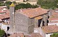
 An aerial view of Alairac | |
 Coat of arms | |
Location of Alairac  | |
 Alairac  Alairac | |
| Coordinates: 43°11′06″N 2°14′29″E | |
| Country | France |
| Region | Occitania |
| Department | Aude |
| Arrondissement | Carcassonne |
| Canton | Carcassonne-3 |
| Intercommunality | Carcassonne Agglo |
| Government | |
| • Mayor (2020–2026) | Marc Adivèze |
| Area 1 | 16.37 km2 (6.32 sq mi) |
| Population | 1,313 |
| • Density | 80/km2 (210/sq mi) |
| Time zone | UTC+01:00 (CET) |
| • Summer (DST) | UTC+02:00 (CEST) |
| INSEE/Postal code | 11005 /11290 |
| Elevation | 158–422 m (518–1,385 ft) (avg. 190 m or 620 ft) |
| 1 French Land Register data, which excludes lakes, ponds, glaciers > 1 km2 (0.386 sq mi or 247 acres) and river estuaries. | |
The inhabitants of the commune are known as Alairacois, or Alairacoises.[2]
Geography
The commune is in the urban area of Carcassonne and is located on a hillock at the foot of the Malepère mountain range. Alairac is a traditional circulade village dating to 1000AD. The commune has been part of the agglomeration community called Carcassonne Agglo since 1 January 2010.
The commune is located some 80 km south-east of Toulouse and only 6 km south-west of Carcassonne. The Motorway E80 (A61) passes across the northern tip of the commune but has no exit. The commune can be reached by Road D18 from Carcassonne which passes in a south-westerly direction through the heart of the commune towards Cailhau. Road D211 also passes through the commune from Arzens in the west to Lavalette in the east passing to the north of Alairac village. The village can be reached by a number of local roads from both the D211 and the D18. The commune is both farmland and forest with a two small hamlets: Galet and Les Rougeats.[3]
Several streams pass through the commune. In the east the Ruisseau Saint Pierre forms the eastern border of the commune, the Ruisseau de Bonne Mere forms the southern boundary, and the Ruisseau du Sout forms the western boundary. Inside the commune there are several streams with the Ruisseau de Celule Ou Gautel passing near the village. All the streams eventually flow into the river Aude which continues east into the Mediterranean Sea.[3]
Neighbouring communes and towns
Places adjacent to Alairac | ||||||||||||||||
|---|---|---|---|---|---|---|---|---|---|---|---|---|---|---|---|---|
| ||||||||||||||||
Geology, topography and hydrography
The village overlooks the plain where the Canal du Midi to the north of the commune towards Carcassonne and the view extends over a panorama limited to the north by the Montagne Noire (Black Mountain). To the north-east is the city of Carcassonne and to the south the Malepère mountain range covered in oak forest, the domain of wild boar and mushroom collectors.
Climate
The village has an oceanic climate with a strong Mediterranean influence. This area is dominated by Holly Oak forests which makes it suitable for the cultivation of the grapevines. The summers are temperate and the winters mild.
History
The first written record of the castle appeared in 1063: the time of the probable construction of the circulade. The area belonged to the Count of Foix, the first of which was Roger I de Foix who was the second son of Bernard-Roger, Count of Bigorre. Over the years, he exchanged the County of Foix with the Viscount of Carcassonne several times to the Trencavel family.
From the 11th century, the village was traversed by one of the paths to Saint Jacques de Compostela called "Path of the Pyrenean Piedmont". This pilgrimage continued until the 18th century.
During the Albigensian Crusade at Easter 1210, Simon de Montfort besieged the castle at Alairac for eleven days at which the people, fearing they may have to surrender, fled by night. In 1309, the last known Cathar perfect, Guillaume Bélibaste, fled Catalonia with Philippe of Alayrac. The latter, on his return home after ten years of exile, was probably captured and burned.

On hearing the sound of an approaching large company from Routiers in 1366, the officers of the Bailiwick of Carcassonne ordered the inhabitants of the castle at Alairac — which belonged to Jean d'Armagnac — to fortify it and destroy the surrounding area. Having failed to execute the order, the Viscount angrily set fire to the castle which was completely burned. Later, the Count of Armagnac ceded the land of Alairac to the Marquis of Mirepoix in 1404.
The lordship was sold at the beginning of the 18th century to a citizen of Carcassonne. This lordship was extinguished by the Revolution in 1789.
During the First World War from 1914 to 1918, the village lost nineteen people whose names are inscribed on the memorial. Every year on 11 November, this sacrifice is remembered by reading their names during a ceremony attended by schoolchildren.
During the Algerian War, many young people from Alairac were called to fight. One of them was killed. Every 19 March the laying of wreaths takes place to commemorate the date the Évian Accords came into force.
Heraldry
 |
Or means a gold background, pale, in heraldry is a vertical band in the middle of the shield and bounded by two lines, tapering: indicates the tapering of the pale, Vert: means the colour green
Blazon:
|
Administration
This list is incomplete; you can help by adding missing items. (April 2021) |
List of Successive Mayors of Alairac[4]
| From | To | Name | Party |
|---|---|---|---|
| 1862 | 1871 | Louis Guilhem | |
| 1871 | 1871 | Guilhem benoit | |
| 1871 | 1900 | Jean Fages | |
| 1900 | 1919 | Guilhem Achilles | |
| 1919 | 1929 | Fages Irenaeus | |
| 1929 | 1935 | Gaston Vidal | |
| 1935 | 1945 | Fages Irenaeus | |
| 1945 | 1952 | Urban Marcerou | |
| 1952 | 1953 | André Mouls | |
| 1953 | 1971 | Carrie Antonin | |
| 1971 | 2020 | Roger Adivèze | PS |
| 2020 | 2026 | Marc Adivèze |
Population
| Year | Pop. | ±% p.a. |
|---|---|---|
| 1968 | 357 | — |
| 1975 | 359 | +0.08% |
| 1982 | 537 | +5.92% |
| 1990 | 618 | +1.77% |
| 1999 | 708 | +1.52% |
| 2007 | 1,193 | +6.74% |
| 2012 | 1,305 | +1.81% |
| 2017 | 1,330 | +0.38% |
| 2019 | 1,313 | −0.64% |
| Source: INSEE[5] | ||
Economy
Viticulture: Malepère (AOC)
Culture and heritage

Civil heritage
- The Circulade of Alairac with its circular boulevard called Rond Saint-Germain: the heart of the village
- The War memorial surmounted by a Gallic rooster on which is inscribed the names of the twenty young men of the village who were killed during the wars of the 20th century
- A Courtyard shaded by acacias at the primary school dating from 1935
- The village is crossed by one of the roads of the Way of Saint James leading to Saint-Jacques de Compostela
Religious heritage
The commune has several religious buildings and structures that are registered as historical monuments:
- The Parish Church of Saint Germain (14th century)
 [6] with an octagonal bell tower which originally served as a Fortified tower. The Church contains two items that are registered as historical objects:
- The Catuffe Cross (1645)[9] on the Chamin des Castelles.
- The Alairac Cross (17th century),[10] a Saint Germain style round cross.
Gallery
 Church of Saint-Germain d'Alairac
 Octagonal Bell Tower from the 13th century
 Saint-Germain round cross
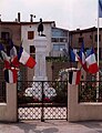 Twenty names engraved on the War memorial
 The Cross of Catufe from the 17th century
 The courtyard of the primary school
 Snow on the primary school courtyard


Culture and festivals
- The Alain Cazalis Library is associated with the library of the Aude
- In March there is Printemps de notes (Spring notes), an artistic and musical festival of Alairac in Malepère
- In May De circulade en circulade is hosted, comprising plays, lectures, and local bands together with fourteen other circulade villages of Aude.
- On the first Sunday of June there is a hunting feast with a Mass for Saint Hubert to bless the packs of dogs
- In the last weekend of July there is the village fete
Children's activities
There is a hall for teenagers (12–17 years old) organised by the CIAS of Carcassonne. This activity is supervised by Mathieu Bruno the organiser.
Facilities
Education
- In total one hundred and fifty children were enrolled in the Alairac public school in 2012 which has both a primary school[11] built in 1935 and a kindergarten which was built in 2002
- From eleven years old most of the children go to the Varsovie College at Carcassonne.
Sports
- Football club of the Malepère in association with Lavalette and Roullens
- Tennis accord between the Malepère and Alairac, Caux-et-Sauzens, Preixan, Arzens, and Lavalette.
- Cycling Club
- Motorcycle club, with the Escande track and the motocross international circuit at Escande
Notable people linked to the commune
- Philippe of Alayrac, companion of the last Cathar Perfect, Guillaume Bélibaste
- André Mouls, playwright and Occitan poet
- Alain Cazalis (1950-2012), Deputy Mayor, Deputy for Culture, defender of "rural culture", including the creator of the Spring notes festival and initiator of the association De circulade en circulade
- Roger Adivèze former regional councilor, officer of the Legion of Honour, mayor between 1971 and 2020 and vice president of the Carcassonne Agglo since January 2010, and also Chairman of the management centre of the territorial public service of Aude.
See also
External links
- Alairac official website (in French)
- Alairac page on the circulades website
- Alairac on Géoportail, National Geographic Institute (IGN) website (in French)
- Alairac on the 1750 Cassini Map
References
- "Populations légales 2019". The National Institute of Statistics and Economic Studies. 29 December 2021.
- Inhabitants of Aude (in French)
- Google Maps
- List of Mayors of France (in French)
- Population en historique depuis 1968, INSEE
- Ministry of Culture, Mérimée PA00102513 Parish Church of Saint Germain (in French)
- Ministry of Culture, Palissy PM11000591 Chalice with Paten (in French)
- Ministry of Culture, Palissy PM11000590 Chalice with Paten (in French)
- Ministry of Culture, Mérimée PA00102512 Catuffe Cross (in French)
- Ministry of Culture, Mérimée PA00102511 Alairac Cross (in French)

- Alairac School (in French)
На других языках
- [en] Alairac
[ru] Алерак
Алера́к (фр. Alairac) — коммуна во Франции в регионе Лангедок — Руссильон, департамент Од.Другой контент может иметь иную лицензию. Перед использованием материалов сайта WikiSort.org внимательно изучите правила лицензирования конкретных элементов наполнения сайта.
WikiSort.org - проект по пересортировке и дополнению контента Википедии