world.wikisort.org - Czech
Pchery (Czech pronunciation: [ˈpxɛrɪ]) is a municipality and village in Kladno District in the Central Bohemian Region of the Czech Republic. It has about 2,000 inhabitants.
Pchery | |
|---|---|
Municipality | |
 Pchery from summit of the Vinařická hora | |
 Flag  Coat of arms | |
 Pchery Location in the Czech Republic | |
| Coordinates: 50°11′29″N 14°6′51″E | |
| Country | |
| Region | Central Bohemian |
| District | Kladno |
| First mentioned | 1222 |
| Area | |
| • Total | 6.75 km2 (2.61 sq mi) |
| Elevation | 324 m (1,063 ft) |
| Population (2022-01-01)[1] | |
| • Total | 1,985 |
| • Density | 290/km2 (760/sq mi) |
| Time zone | UTC+1 (CET) |
| • Summer (DST) | UTC+2 (CEST) |
| Postal code | 273 08 |
| Website | www |
Administrative parts

The village of Humny is an administrative part of Pchery.
Geography
Pchery is located about 5 km (3 mi) north of Kladno. It lies in a flat agricultural landscape of the Prague Plateau.
History
The first written mention of Pchery is from 1222. A document from about 1228 states that it was a property of the St. George's Convent of Prague Castle.[2]
In 1897, Theodor Mine was founded south of Pchery. The black coal mine was in operation between 1902 and 1935. The eponymous hamlet, formerly a miners' settlement which arose around the mine, also belongs to the municipal territory of Pchery.[3]
Economy
A wind power plant has been operating on a field about 1 km northeast of Pchery since 1 April 2008. It consists of two towers of 88 m (289 ft) in height, each equipped with a 3 MW wind turbine supplied by Finnish manufacturer WinWinD. As of 2008 it was the most powerful wind power plant in the country. As of 2020, it is the 12th most powerful in the country, and the most powerful in the Central Bohemian Region.[4]
Sights
The Church of Saint Stephen is the oldest monument in Pchery. It was first attested in a tithe registry in 1352. It was enlarged from one to three naves in the Baroque style in 1706. Above the church stands a belfry built in the mid-18th century.[2]
Notable people
- Oldřich Duras (1882–1957), chess grandmaster
Gallery
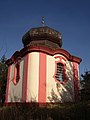 Belfry
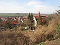 Church of Saint Stephen as seen from the belfry
 House No. 7 with statues of saints in niches besides the gate
 Main road in the centre of Pchery
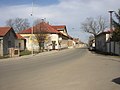 The hamlet of Theodor
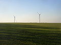 Wind power plant


References
- "Population of Municipalities – 1 January 2022". Czech Statistical Office. 2022-04-29.
- "Historie" (in Czech). Obec Pchery. Retrieved 2022-05-18.
- "Důl Theodor u Pcher" (in Czech). Zdař Bůh. Retrieved 2022-05-18.
- "Current installation in wind". Czech Wind Energy Association. Retrieved 2021-06-25.
External links
| Wikimedia Commons has media related to Pchery. |
- Official website (in Czech)
- Wind power plant Pchery (in Czech)
| Authority control: National libraries |
|---|
Другой контент может иметь иную лицензию. Перед использованием материалов сайта WikiSort.org внимательно изучите правила лицензирования конкретных элементов наполнения сайта.
WikiSort.org - проект по пересортировке и дополнению контента Википедии