world.wikisort.org - Czech
Kutrovice (Czech pronunciation: [ˈkutrovɪtsɛ]) is a municipality and village in Kladno District in the Central Bohemian Region of the Czech Republic. It has about 100 inhabitants.
Kutrovice | |
|---|---|
Municipality | |
 View from the south | |
 Flag  Coat of arms | |
 Kutrovice Location in the Czech Republic | |
| Coordinates: 50°15′42″N 14°1′8″E | |
| Country | |
| Region | Central Bohemian |
| District | Kladno |
| First mentioned | 1366 |
| Area | |
| • Total | 1.49 km2 (0.58 sq mi) |
| Elevation | 260 m (850 ft) |
| Population (2022-01-01)[1] | |
| • Total | 108 |
| • Density | 72/km2 (190/sq mi) |
| Time zone | UTC+1 (CET) |
| • Summer (DST) | UTC+2 (CEST) |
| Postal code | 273 75 |
| Website | www |
Geography
Kutrovice is located about 14 kilometres (9 mi) north of Kladno and 31 km (19 mi) northwest of Prague. It lies in an agricultural landscape of the Lower Eger Table. The Bakovský Stream flows through the municipality.
History
The first written mention of Kutrovice is from 1366.[2]
Transport
The main road No. 7 from Prague to Chomutov (part of an unfinished D7 motorway) runs through the municipality.
Sights
Kutrovice lacks any buildings of historical importance, there is only a small Baroque chapel in the municipality.
Gallery
 Bakovský Stream in the centre
 Main street in the southern part
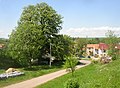 Huge horse-chestnut tree featured in coat of arms
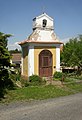 Baroque chapel
 Memorial to victims of the World War I
 Wayside cross


References
- "Population of Municipalities – 1 January 2022". Czech Statistical Office. 2022-04-29.
- "Úvod" (in Czech). Obec Kutrovice. Retrieved 2022-05-19.
External links
| Wikimedia Commons has media related to Kutrovice. |
| Authority control: National libraries |
|---|
Текст в блоке "Читать" взят с сайта "Википедия" и доступен по лицензии Creative Commons Attribution-ShareAlike; в отдельных случаях могут действовать дополнительные условия.
Другой контент может иметь иную лицензию. Перед использованием материалов сайта WikiSort.org внимательно изучите правила лицензирования конкретных элементов наполнения сайта.
Другой контент может иметь иную лицензию. Перед использованием материалов сайта WikiSort.org внимательно изучите правила лицензирования конкретных элементов наполнения сайта.
2019-2026
WikiSort.org - проект по пересортировке и дополнению контента Википедии
WikiSort.org - проект по пересортировке и дополнению контента Википедии