world.wikisort.org - China
Pucheng County (simplified Chinese: 浦城县; traditional Chinese: 浦城縣; pinyin: Pǔchéng Xiàn) is a county under the jurisdiction of the municipality of Nanping, in northern Fujian province, People's Republic of China, bordering Jiangxi to the northwest and Zhejiang to the east; it is the northernmost county-level division of Fujian.
Pucheng County
浦城县 | |
|---|---|
County | |
 Location of Pucheng County within Nanping City | |
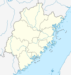 Pucheng Location of the seat in Fujian | |
| Coordinates: 27°54′N 118°31′E | |
| Country | People's Republic of China |
| Province | Fujian |
| Prefecture-level city | Nanping |
| Government | |
| • CPC County Committee Secretary | Zhou Yonghe |
| Area | |
| • Total | 3,383 km2 (1,306 sq mi) |
| • Water | 100 km2 (40 sq mi) |
| Population | |
| • Total | 320,000 |
| • Density | 95/km2 (240/sq mi) |
| in the year 2000 | |
| Time zone | UTC+8 (China Standard) |
| Website | www.pc.gov.cn |
The county is named for the Nanpu Brook, a major tributary to the Min River.
Geography
Pucheng comprises 3,383.02 square kilometres (1,306.19 sq mi) in the Wuyi Mountains which separates Fujian and Jiangxi provinces. It borders Songxi County to the southeast, Jianyang District to the south and Wuyishan City (location of the famous UNESCO park) to the west, all within Nanping. The municipality of Shangrao, Jiangxi, borders to the northwest; those of Quzhou, to the north, and Lishui, to the east, are in Zhejiang.
Climate
| Climate data for Pucheng (1981−2010) | |||||||||||||
|---|---|---|---|---|---|---|---|---|---|---|---|---|---|
| Month | Jan | Feb | Mar | Apr | May | Jun | Jul | Aug | Sep | Oct | Nov | Dec | Year |
| Record high °C (°F) | 27.8 (82.0) |
30.0 (86.0) |
33.0 (91.4) |
34.1 (93.4) |
35.5 (95.9) |
36.2 (97.2) |
42.0 (107.6) |
41.1 (106.0) |
39.3 (102.7) |
37.3 (99.1) |
33.0 (91.4) |
26.0 (78.8) |
42.0 (107.6) |
| Average high °C (°F) | 12.0 (53.6) |
13.8 (56.8) |
17.4 (63.3) |
23.3 (73.9) |
27.3 (81.1) |
29.7 (85.5) |
33.5 (92.3) |
33.3 (91.9) |
30.0 (86.0) |
25.7 (78.3) |
20.2 (68.4) |
14.8 (58.6) |
23.4 (74.1) |
| Daily mean °C (°F) | 6.7 (44.1) |
8.7 (47.7) |
12.2 (54.0) |
17.7 (63.9) |
21.8 (71.2) |
24.8 (76.6) |
27.7 (81.9) |
27.1 (80.8) |
24.0 (75.2) |
19.3 (66.7) |
13.6 (56.5) |
8.2 (46.8) |
17.7 (63.8) |
| Average low °C (°F) | 3.1 (37.6) |
5.2 (41.4) |
8.6 (47.5) |
13.8 (56.8) |
18.0 (64.4) |
21.3 (70.3) |
23.5 (74.3) |
23.1 (73.6) |
20.1 (68.2) |
14.9 (58.8) |
9.2 (48.6) |
3.8 (38.8) |
13.7 (56.7) |
| Record low °C (°F) | −6.6 (20.1) |
−5.0 (23.0) |
−4.5 (23.9) |
2.4 (36.3) |
8.7 (47.7) |
12.6 (54.7) |
18.9 (66.0) |
16.5 (61.7) |
11.3 (52.3) |
2.3 (36.1) |
−2.9 (26.8) |
−7.6 (18.3) |
−7.6 (18.3) |
| Average precipitation mm (inches) | 74.7 (2.94) |
101.0 (3.98) |
197.4 (7.77) |
226.4 (8.91) |
244.2 (9.61) |
368.0 (14.49) |
140.2 (5.52) |
114.1 (4.49) |
89.2 (3.51) |
52.7 (2.07) |
65.1 (2.56) |
46.7 (1.84) |
1,719.7 (67.69) |
| Average relative humidity (%) | 79 | 80 | 81 | 79 | 79 | 82 | 78 | 79 | 79 | 77 | 78 | 76 | 79 |
| Source: China Meteorological Data Service Center[1] | |||||||||||||
Culture
Language
The Pucheng dialect shares some features with Wu, but is classed among the Southern Chinese varieties. It is however not demonstrably a member of the Min subgroup (which covers almost all of Fujian), and pending further research must stand as an isolate - the sole exemplar of the Pucheng group of Southern Chinese.[2] Some Wu dialects and the Northern Min dialect of Shibei are also spoken in Pucheng.
Intangible Cultural Heritage
Administrative divisions
The county administers 2 street offices, 9 towns and 8 townships. The county executive, legislature and judiciary are in Nanpu Street Office, together with the CPC and PSB branches.[3]
Street offices (街道, jiedao)
- Nanpu (南浦) - the county seat
- Hebin (河滨)
Towns (镇, zhen)
- Fuling (富岭)
- Shibei (石陂)
- Linjiang (临江)
- Xianyang (仙阳)
- Shuibeijie (水北街)
- Yongxing (永兴)
- Zhongxin (忠信)
- Liantang (莲塘)
- Jiumu (九牧)
Townships (乡, xiang)
- Wan'an(万安)
- Gulou(古楼)
- Shanxia (山下)
- Fengxi(枫溪)
- Haocun(濠村)
- Guancuo(管厝)
- Panting(盘亭)
- Guanlu(官路)
Transportation
Expressway
- S0311 Pucheng-Jianning Expressway
Specialty
- Pucheng Rouyan/Taipingyan (浦城肉燕/太平燕)
- tofu ball (豆腐丸)
- osmanthus tea (桂花茶)
- wild jujube cake (酸枣糕)
- baojiu (包酒/七倒金)
Archaeology
In 2006 mound tombs of the Wuyue Kingdom were discovered in Guanjiu village. (The kingdom was contemporary with the Spring and Autumn period and Warring States period of the Yellow River-centred Hans). Considered a strongly significant element of Wuyue culture, these are the first such tombs discovered in Fujian Province. 72 bronze funerary articles were excavated from the tombs, making the excavation the largest harvest of bronze items in Fujian archaeological history.
Notable persons
- Ye Jianming, founder and former Chairman of CEFC China Energy Company Limited
References
- 中国地面气候标准值月值(1981-2010) (in Simplified Chinese). China Meteorological Data Service Center. Retrieved 7 November 2022.
- Norman, Jerry, Chinese, Cambridge University Press, 1988, ISBN 0-521-29653-6. p.243
- Fujian Sheng Dituce, China Map Publishing, 1999, ISBN 7-5031-2176-9. p.43
External links
Authority control | |
|---|---|
| General | |
| National libraries | |
На других языках
[de] Pucheng (Nanping)
Der Kreis Pucheng (chinesisch .mw-parser-output .Hans{font-size:110%}浦城县, Pinyin Pǔchéng Xiàn) ist ein Kreis der nordwestlichsten bezirksfreien Stadt Nanping der chinesischen Provinz Fujian. Er hat eine Fläche von 3.381 km² und zählt 297.719 Einwohner (Stand: 2020)[1]. Sein Hauptort ist das Straßenviertel Nanpu (南浦街道).- [en] Pucheng County, Fujian
[fr] Xian de Pucheng (Fujian)
Le xian de Pucheng (浦城县 ; pinyin : Pǔchéng Xiàn) est un district administratif de la province du Fujian en Chine. Il est placé sous la juridiction de la ville-préfecture de Nanping.[ru] Пучэн (Наньпин)
Пучэ́н (кит. упр. 浦城, пиньинь Pǔchéng) — уезд городского округа Наньпин провинции Фуцзянь (КНР).Другой контент может иметь иную лицензию. Перед использованием материалов сайта WikiSort.org внимательно изучите правила лицензирования конкретных элементов наполнения сайта.
WikiSort.org - проект по пересортировке и дополнению контента Википедии