world.wikisort.org - China
Changtu County (simplified Chinese: 昌图县; traditional Chinese: 昌圖縣; pinyin: Chāngtú Xiàn) is a county in the northeast of Liaoning province, China, bordering Jilin to the northeast and Inner Mongolia in the northwest. It is under the administration of Tieling City, the downtown of which lies 60 kilometres (37 mi) to the south-southwest, and is 47 kilometres (29 mi) southwest of Siping, Jilin. It is served by both China National Highway 102 and G1 Beijing–Harbin Expressway.
Changtu
昌图县 | |
|---|---|
County | |
 A wind farm in Changtu County | |
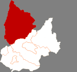 Location in Tieling | |
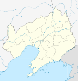 Changtu Location of the seat in Liaoning | |
| Coordinates (Changtu County government): 42°47′09″N 124°06′40″E | |
| Country | People's Republic of China |
| Province | Liaoning |
| Prefecture-level city | Tieling |
| County seat | Changtu, Changtu County |
| Area | |
| • Total | 4,321.7 km2 (1,668.6 sq mi) |
| Elevation | 152 m (499 ft) |
| Population (2019) | |
| • Total | 984,226 |
| • Density | 230/km2 (590/sq mi) |
| Time zone | UTC+8 (China Standard) |
| Postal code | 112500 |
| Website | http://www.changtu.gov.cn/ |
Administrative divisions

There are 33 towns under the county's administration.[1]
Towns:
- Changtu (昌图镇)
- Laocheng (老城镇)
- Bamiancheng (八面城镇)
- Sanjiangkou (三江口镇)
- Jinjia (金家镇)
- Baoli (宝力镇)
- Quantou (泉头镇)
- Shuangmiaozi (双庙子镇)
- Liangzhongqiao (亮中桥镇)
- Mazhonghe (马仲河镇)
- Maojiadian (毛家店镇)
- Laosiping (老四平镇)
- Dawa (大洼镇)
- Toudao (头道镇)
- Cilushu (𪉈鹭树镇)
- Fujia (傅家镇)
- Sihe (四合镇)
- Chaoyang (朝阳镇)
- Guyushu (古榆树镇)
- Qijiazi (七家子镇)
- Dongga (东嘎镇)
- Simiancheng (四面城镇)
- Qianshuangjing (前双井镇)
- Tongjiangkou (通江口镇)
- Dasijiazi (大四家子镇)
- Qujiadian (曲家店镇)
- Shibajiazi (十八家子镇)
- Taiping (太平镇)
- Xia'ertai (下二台镇)
- Ping'anbao (平安堡镇)
- Daxing (大兴镇)
- Houyao (后窑镇)
- Changfa (长发镇)
Demographics
As of 2019, Changtu County has a population of 984,226 people, of which 29.89% lived in urban settlements, and the remaining 70.11% lived in rural ones.[2] Of this population, 50.5% was male, 49.5% was female, 13.11% were aged 17 and under, 20.05% were between 18 and 34 years old, 43.68% were between 35 and 59, and the remaining 23.16% were aged 60 and older.[2]
Climate
| Climate data for Changtu (1981−2010) | |||||||||||||
|---|---|---|---|---|---|---|---|---|---|---|---|---|---|
| Month | Jan | Feb | Mar | Apr | May | Jun | Jul | Aug | Sep | Oct | Nov | Dec | Year |
| Record high °C (°F) | 5.6 (42.1) |
16.0 (60.8) |
20.3 (68.5) |
29.3 (84.7) |
33.5 (92.3) |
35.8 (96.4) |
36.5 (97.7) |
36.4 (97.5) |
32.8 (91.0) |
27.7 (81.9) |
20.4 (68.7) |
12.1 (53.8) |
36.5 (97.7) |
| Average high °C (°F) | −7.5 (18.5) |
−2.5 (27.5) |
5.3 (41.5) |
15.5 (59.9) |
22.4 (72.3) |
26.8 (80.2) |
28.0 (82.4) |
27.4 (81.3) |
22.9 (73.2) |
14.8 (58.6) |
3.4 (38.1) |
−4.6 (23.7) |
12.7 (54.8) |
| Daily mean °C (°F) | −12.9 (8.8) |
−8.1 (17.4) |
−0.2 (31.6) |
9.5 (49.1) |
16.6 (61.9) |
21.5 (70.7) |
23.7 (74.7) |
22.7 (72.9) |
17.0 (62.6) |
8.9 (48.0) |
−1.6 (29.1) |
−9.7 (14.5) |
7.3 (45.1) |
| Average low °C (°F) | −17.7 (0.1) |
−13.2 (8.2) |
−5.2 (22.6) |
3.9 (39.0) |
11.1 (52.0) |
16.7 (62.1) |
19.9 (67.8) |
18.6 (65.5) |
11.7 (53.1) |
3.8 (38.8) |
−5.9 (21.4) |
−14.1 (6.6) |
2.5 (36.4) |
| Record low °C (°F) | −32.8 (−27.0) |
−28.7 (−19.7) |
−19.8 (−3.6) |
−7.9 (17.8) |
0.3 (32.5) |
5.7 (42.3) |
12.5 (54.5) |
7.6 (45.7) |
−0.4 (31.3) |
−10.6 (12.9) |
−22.0 (−7.6) |
−28.9 (−20.0) |
−32.8 (−27.0) |
| Average precipitation mm (inches) | 4.1 (0.16) |
4.7 (0.19) |
14.9 (0.59) |
28.4 (1.12) |
50.7 (2.00) |
86.3 (3.40) |
156.5 (6.16) |
151.7 (5.97) |
54.5 (2.15) |
29.2 (1.15) |
14.5 (0.57) |
5.6 (0.22) |
601.1 (23.68) |
| Average relative humidity (%) | 63 | 56 | 50 | 48 | 51 | 65 | 80 | 79 | 68 | 60 | 62 | 63 | 62 |
| Source: China Meteorological Data Service Center[3] | |||||||||||||
Economy
Changtu County's gross domestic product (GDP) reached a total of ¥13.32 billion in 2019, a 2.9% increase from the previous year.[2] Of this, 46.5% came from the county's primary sector, 13.0% came from the secondary sector, and 40.5% came from the tertiary sector.[2]
As of 2019, the average annual salary in Changtu County is ¥34,915, a 7.6% increase from the previous year.[2] Urban unemployment in 2019 was 3.74%.[2]
Agriculture and animal husbandry
The county's agriculture, forestry, animal husbandry, and fishing industries combined accounted for ¥13.87 billion of economic value in 2019.[2] Agriculture in the county is dominated by the growing of maize, although the cultivation of seed oil, vegetables, soybeans, and rice are also substantial.[2] Large amounts of swine, cattle, and poultry are raised in Changtu County.[2] A smaller, yet substantial, amount of sheep are also raised.[2]
Tourism
In 2019, 540,000 tourists visited Changtu County, generating revenue of ¥30 million.[2]
Education
As of 2019, the county reported having 98 public schools serving 66,397 students.[2] The county has 187 kindergartens, including 44 public ones.[2] There are 44 primary schools,[4] 36 junior high schools,[4][dead link] 5 nine-year schools,[4][dead link] 3 high schools,[2] as well as a number of vocational schools.[2]
High schools
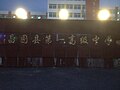 No.1 Senior High School, Changtu
 Changtu Vocational Education Center


One of the three high schools serving the county is Changtu No.1 Senior High, which has over 2,500 students.[5] The school's campus covers an area of 90,600 square metres.[5]
Middle schools
 Shiyan Junior High School, Changtu

A school that is close to one-third the size of No.1 Senior High is Shiyan Junior High[citation needed]. This school covers about 28 kilometers squared[citation needed].
Healthcare
As of 2019, Changtu County has 36 medical institutions, which contain 3,845 hospital beds.[2]
References
- 2020年统计用区划代码(昌图县) (in Chinese). National Bureau of Statistics of the People's Republic of China. 2020. Archived from the original on 28 November 2020. Retrieved 11 September 2021.
- 昌图统计信息(2019) [Changtu Statistical Information (2019)]. www.tieling.gov.cn (in Chinese). Changtu County People's Government. 9 December 2020. Archived from the original on 11 September 2021. Retrieved 11 September 2021.
- 中国地面气候标准值月值(1981-2010) (in Simplified Chinese). China Meteorological Data Service Center. Retrieved 24 September 2022.
- 2016年昌图县国民经济和社会发展统计公报 (in Chinese (China)). Changtu County People's Government.
{{cite web}}: CS1 maint: url-status (link) [dead link] - 学校简介 [School Introduction]. www.ctgz.cn (in Chinese). Changtu No. 1 Senior High School. Archived from the original on 12 October 2016. Retrieved 11 September 2021.
External links
На других языках
- [en] Changtu County
[ru] Чанту
Чанту́ (кит. упр. 昌图, пиньинь Chāngtú) — уезд городского округа Телин провинции Ляонин (КНР).Другой контент может иметь иную лицензию. Перед использованием материалов сайта WikiSort.org внимательно изучите правила лицензирования конкретных элементов наполнения сайта.
WikiSort.org - проект по пересортировке и дополнению контента Википедии