world.wikisort.org - Brazil
Cachoeiro de Itapemirim (local Portuguese pronunciation: [kaʃuˈe(j)ɽu ˌdʒiːtapemiˈɾĩj]) is a municipality and a major town, located in the south of Espírito Santo, Brazil, on the banks of the Itapemirim River. It is the economic hub of southern Espírito Santo, being the most important producer of marble and granite in Brazil. Home to one of the biggest intercity bus companies, it is a very well-connected city. The population is about 210,000. Location: 138 km south of Vitória.
Cachoeiro de Itapemirim | |
|---|---|
Municipality | |
| Município de Cachoeiro de Itapemirim Municipality of Cachoeiro de Itapemirim | |
 Montages of the city Cachoeiro de Itapemirim. Top left: Sunset in River Itapemirim, Top right: View of Center of Cachoeiro de Itapemirim, Middle left: St. Peter's Cathedral, Middle right: River Itapemirim, Bottom left: Night view of Iron Bridge Demisthóclides Baptista, Bottom right: Fátima Square. | |
 Flag  Coat of arms | |
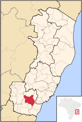 Localization in Espírito Santo | |
 Cachoeiro de Itapemirim Localization in Brazil | |
| Coordinates: 20°50′56″S 41°06′46″W | |
| Country | |
| Region | Southeast |
| State | |
| Founded | November 11, 1890 |
| Government | |
| • Type | Mayor-council |
| • Body | Prefeitura da Cidade de Cachoeiro de Itapemirim |
| • Mayor | Victor Coelho (PSB (2017–2020)) |
| Area | |
| • Total | 864.583 km2 (333.817 sq mi) |
| Elevation | 22 m (72 ft) |
| Population (2020 est.[2]) | |
| • Total | 210,589 |
| • Rank | 2nd |
| • Density | 240/km2 (630/sq mi) |
| Demonym | Cachoeirense |
| Time zone | UTC−3 (BRT) |
| Area code | +55 28 |
The city is served by Cachoeiro de Itapemirim Airport.
History
Cachoeiro de Itapemirim's first commercial establishment opened in 1853, and in 1889 its first post office and telegram services were begun. Since its early days, transport has played a major role in this town. Since it was established by a waterfall, where it would be impossible to continue the journey up the river, it became an important stop for gold prospectors traveling to Minas Gerais. Many immigrant families which travelled to southern Espírito Santo established in the region.
Transport
The railway line to Rio de Janeiro was completed in 1900, allowing both cultural and economical influence from the latter. In 1911 the railway to Vitória was completed, strengthening links to the north.
Attractions
The municipality contains the 451 hectares (1,110 acres) Pacotuba National Forest, created in 2002.[3] The quilombola community of Monte Alegre offers ethnic, cultural and environmental tourism in partnership with the forest and the ministry of tourism. This includes crafts and gastronomy, expression of traditions and community lifestyle, and guided tours of the forest.[4] The municipality contains part of the protected area of the Frade e a Freira Natural Monument.[5] It contains the 452 hectares (1,120 acres) Itabira Natural Monument.[6] The city is nicknamed A capital oculta do mundo, meaning "the secret capital of the world".
People
- Bujica (Marcelo Ribeiro), retired professional footballer
- Roberto Carlos, singer [7] known as The King of Brazilian Music [8]
- Maxwell Cabelino Andrade, football player, currently playing at Paris Saint Germain
- Rubem Braga, a chronist writer
- Luz del Fuego, actress, famous in the United States in the 1950s, starred on Broadway IMDB
- Noemi Cavalcanti, actress IMDB
- Sérgio Sampaio, actor IMDB
- Raul Sampaio, actor IMDB
- Carlos Imperial, actor
- Charles Fricks, actor IMDB
- Carlos Nemer, architect
- Ramon de Morais Motta, footballer
- Anderson Freire, singer
- Larissa França, professional beach volleyball player and holder of the Guinness World Record for most women’s FIVB Beach Volleyball World Tour gold medals won by an individual
References
- "Brazilian Institute of Geography and Statistics" (in Portuguese). 2017. Retrieved March 27, 2019.
2018 Area Total
- IBGE 2020
- Gonçalves, Augusta Rosa; Helmer, José Luiz (June 2011), Plano De Manejo Da Floresta Nacional De Pacotuba (PDF) (in Portuguese), vol. I–Diagnóstico, Vila Vilha: ICMBio, p. 3, retrieved October 27, 2016
- Floresta Nacional de Pacotuba (in Portuguese), Via Rural, archived from the original on October 28, 2016, retrieved October 27, 2016
- Monumento Natural O Frade e a Freira (in Portuguese), Secretário de Meio Ambiente, Espírito Santo, archived from the original on June 3, 2016, retrieved May 6, 2016
- Official Record for Monumento Natural Do Itabira, Protected Planet, retrieved October 24, 2016
- "A Listing of Grammy Award Winners". The New York Times. February 23, 1989.
- "10 Most Influential Brazilian Music Artists".
External links
- History and Images of Cachoeiro de Itapemirim (in Portuguese)
- images Google Maps of Cachoeiro de Itapemirim
Capital: Vitória | ||||||||||
| Mesoregion Central |
|  | ||||||||
| Mesoregion Litoral Norte |
| |||||||||
| Mesoregion Noroeste |
| |||||||||
| Mesoregion Sul |
| |||||||||
Authority control | |
|---|---|
| General | |
| National libraries | |
| Other |
|
На других языках
[de] Cachoeiro de Itapemirim
Cachoeiro de Itapemirim, amtlich Município de Cachoeiro de Itapemirim, ist eine Stadt im brasilianischen Bundesstaat Espírito Santo. Sie hat laut amtlicher Schätzung zum 1. Juli 2016 210.325 Einwohner und ist damit die fünftgrößte Stadt des Bundesstaates.[1]- [en] Cachoeiro de Itapemirim
[ru] Кашуэйру-ди-Итапемирин
Кашуэйру-ди-Итапемирин (порт. Cachoeiro de Itapemirim) — муниципалитет в Бразилии, входит в штат Эспириту-Санту. Составная часть мезорегиона Юг штата Эспириту-Санту. Входит в экономико-статистический микрорегион Кашуэйру-ди-Итапемирин. Население составляет 195 288 человек на 2007 год. Занимает площадь 876,792 км². Плотность населения — 222,7 чел./км².Другой контент может иметь иную лицензию. Перед использованием материалов сайта WikiSort.org внимательно изучите правила лицензирования конкретных элементов наполнения сайта.
WikiSort.org - проект по пересортировке и дополнению контента Википедии