world.wikisort.org - Australia
The Shire of Mitchell is a local government area in the Hume region of Victoria, Australia, located North of Melbourne. It covers an area of 2,862 square kilometres (1,105 sq mi) and, in June 2018, had a population of 44,299.[1] It includes the towns of Broadford, Kilmore, Seymour, Tallarook, Pyalong and Wallan. It was formed in 1994 from the amalgamation of the Shire of Pyalong, the Shire of Kilmore, most of the Shire of Broadford, and parts of the Shire of McIvor and Rural City of Seymour.[2]
| Shire of Mitchell Victoria | |||||||||||||||
|---|---|---|---|---|---|---|---|---|---|---|---|---|---|---|---|
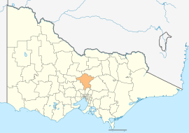 Location in Victoria | |||||||||||||||
| Population | 44,299 (2018)[1] | ||||||||||||||
| • Density | 15.4783/km2 (40.089/sq mi) | ||||||||||||||
| Established | 1994 | ||||||||||||||
| Gazetted | 18 November 1994[2] | ||||||||||||||
| Area | 2,862 km2 (1,105.0 sq mi)[1] | ||||||||||||||
| Mayor | Cr Rhonda Sanderson | ||||||||||||||
| Council seat | Broadford | ||||||||||||||
| Region | Hume Goulburn Valley | ||||||||||||||
| State electorate(s) |
| ||||||||||||||
| Federal division(s) |
| ||||||||||||||
| Website | Shire of Mitchell | ||||||||||||||
| |||||||||||||||
The Shire is governed and administered by the Mitchell Shire Council; its seat of local government and administrative centre is located at the council headquarters in Broadford, it also has service centres located in Kilmore, Seymour and Wallan. The Shire is named after an early British surveyor and explorer, Major Thomas Mitchell, who explored the south-eastern part of Australia, and whose return route for his third expedition passed through the present-day LGA.
It is one of the fastest growing regional municipalities in Victoria.
Council
Current composition
The council is composed of three wards and nine councillors, with three councillors per ward elected to represent each ward.[3]
| Ward | Councillor | Notes | |
|---|---|---|---|
| Central | Louise Bannister | Independent.[4] | |
| Annie Goble | Independent | ||
| Nathan Clark | Independent | ||
| North | Bill Chisholm | Independent | |
| Rhonda Sanderson | Independent | ||
| Fiona Stevens | Independent | ||
| South | Bob Cornish | Independent | |
| Rob Eldridge | Independent | ||
| Christine Banks | Independent | ||
Administration and governance
The council meets in the council chambers at the council headquarters in the Broadford Civic Centre, which is also the location of the council's administrative activities. It also provides customer services at both its administrative centre in Broadford, and its service centres in Kilmore, Seymour and Wallan.
Towns and localities
In June 2018 the shire had a population of 44,299.[1]
| Population | |
| Locality | Total |
| Avenel | 1,048 |
| Beveridge | 2,330 |
| Broadford | 4,319 |
| Bylands | 131 |
| Clonbinane | 330 |
| Forbes | 126 |
| Glenaroua | 154 |
| Glenhope | 76 |
| Glenhope East | 30 |
| Population | |
| Locality | Total |
| Heathcote Junction | 839 |
| Heathcote South | 14 |
| High Camp | 108 |
| Hilldene | 346 |
| Kilmore | 7,958 |
| Kilmore East | 417 |
| Mangalore | 182 |
| Mia Mia | 178 |
| Moranding | 185 |
| Population | |
| Locality | Total |
| Northwood | 195 |
| Nulla Vale | 63 |
| Puckapunyal | 1,078 |
| Pyalong | 660 |
| Reedy Creek | 166 |
| Seymour | 6,327 |
| Sugarloaf Creek | 244 |
| Sunday Creek | 309 |
| Tallarook | 736 |
| Population | |
| Locality | Total |
| Tarcombe | 42 |
| Trawool | 108 |
| Tooborac | 310 |
| Tyaak | 73 |
| Upper Plenty | 335 |
| Wallan | 11,074 |
| Wandong | 1,340 |
| Waterford Park | 193 |
| Whiteheads Creek | 348 |
| Willowmavin | 216 |
See also
- List of localities (Victoria)
- List of places on the Victorian Heritage Register in the Shire of Mitchell
References
- "3218.0 – Regional Population Growth, Australia, 2017-18: Population Estimates by Local Government Area (ASGS 2018), 2017 to 2018". Australian Bureau of Statistics. Australian Bureau of Statistics. 27 March 2019. Retrieved 25 October 2019. Estimated resident population, 30 June 2018.
- Victoria Government Gazette – Online Archive (1837–1997). "S87 of 1994: Order estg (Part 10) the Shire of Mitchell". State Library of Victoria. State Government of Victoria (published 18 November 1994). p. 4. Retrieved 10 January 2014.
- Local Government in Victoria. "Mitchell Shire Council". Department of Transport, Planning and Local Infrastructure. State Government of Victoria. Retrieved 10 January 2014.
- "Nominations | Victorian Electoral Commission". www.vec.vic.gov.au. Archived from the original on 29 September 2020.
External links
- Mitchell Shire Council official website
- Metlink local public transport map
- Link to Land Victoria interactive maps
This Australian government-related article is a stub. You can help Wikipedia by expanding it. |
This article about a location in Hume (region) is a stub. You can help Wikipedia by expanding it. |
На других языках
[de] Mitchell Shire
-37.2145.06666666667 Mitchell Shire ist ein lokales Verwaltungsgebiet (LGA) im australischen Bundesstaat Victoria. Das Gebiet ist 2862,1 km² groß und hat etwa 41.000 Einwohner.[1]- [en] Shire of Mitchell
Другой контент может иметь иную лицензию. Перед использованием материалов сайта WikiSort.org внимательно изучите правила лицензирования конкретных элементов наполнения сайта.
WikiSort.org - проект по пересортировке и дополнению контента Википедии