world.wikisort.org - Australia
The Shire of Loddon is a local government area in Victoria, Australia, located in the northern part of the state. It covers an area of 6,696 square kilometres (2,585 sq mi) and in 2021 had a population of 7,759.[3]
| Shire of Loddon Victoria | |||||||||||||||
|---|---|---|---|---|---|---|---|---|---|---|---|---|---|---|---|
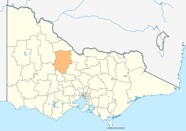 Location in Victoria | |||||||||||||||
| Population | 7,759 (2021)[1] | ||||||||||||||
| • Density | 1.15875/km2 (3.0012/sq mi) | ||||||||||||||
| Established | 1995 | ||||||||||||||
| Gazetted | 19 January 1995[2] | ||||||||||||||
| Area | 6,696 km2 (2,585.3 sq mi)[1] | ||||||||||||||
| Mayor | Cr Dan Straub | ||||||||||||||
| Council seat | Wedderburn | ||||||||||||||
| Region | Northern Victoria | ||||||||||||||
| State electorate(s) |
| ||||||||||||||
| Federal division(s) | Mallee | ||||||||||||||
| Website | Shire of Loddon | ||||||||||||||
| |||||||||||||||
It includes the towns of Inglewood, Boort, Serpentine, Pyramid Hill and Wedderburn. It was formed in 1995 from the amalgamation of the Shire of East Loddon, Shire of Gordon, Shire of Korong, and parts of the Rural City of Marong, Shire of Bet Bet, Shire of Maldon and Shire of Tullaroop.[2]
The Shire is governed and administered by the Loddon Shire Council; its seat of local government and administrative centre is located at the council headquarters in Wedderburn, it also has a service centre located in Serpentine. The Shire is named after the Loddon River, a major geographical feature that meanders through the LGA.
Council
Current composition
The council is composed of five wards and five councillors, with one councillor per ward elected to represent each ward.[4]
| Ward | Councillor | Notes | |
|---|---|---|---|
| Boort | Neil Beattie | ||
| Inglewood | Wendy Murphy | ||
| Tarnagulla | Linda Jungwirth | ||
| Terrick | Dan Straub | Mayor | |
| Wedderburn | Gavan Holt | ||
Administration and governance
The council meets in the council chambers at the Wedderburn Municipal Offices. It also provides customer services at both its administrative centre in Wedderburn, and its service centre in Serpentine.
Traditional owners
The Dja Dja Wurrung and Barababaraba are the traditional owners of this land.[5]
Main towns in shire
In 2021 the shire had a population of 7,759.[6]
| Population | ||
| Locality | 2016 | 2021 |
| Arnold | 47 | 56 |
| Bears Lagoon | 72 | 53 |
| Boort | 873 | 940 |
| Borung | 82 | 59 |
| Bridgewater On Loddon | 326 | 341 |
| Dingee | 206 | 195 |
| Durham Ox | 74 | 60 |
| Eddington | 96 | 113 |
| Fentons Creek | 105 | 27 |
| Population | ||
| Locality | 2016 | 2021 |
| Inglewood | 1,058 | 886 |
| Korong Vale | 168 | 143 |
| Laanecoorie | 177 | 179 |
| Mitiamo | 117 | 116 |
| Mysia | 43 | 26 |
| Newbridge | 192 | 171 |
| Prairie | 66 | 37 |
| Pyramid Hill | 430 | 598 |
| Rheola | 56 | 52 |
| Population | ||
| Locality | 2016 | 2021 |
| Serpentine | 192 | 222 |
| Shelbourne | 452 | 423 |
| Tarnagulla | 133 | 153 |
| Wedderburn | 663 | 951 |
| Wychitella | 31 | 29 |
| Yando | 40 | 45 |
| Yarraberb | 23 | 17 |


See also
- List of places on the Victorian Heritage Register in the Shire of Loddon
References
- "2021 Census All persons QuickStats - Loddon LGA". Australian Bureau of Statistics. 2021. Retrieved 12 August 2022. Estimated resident population, 2022.
- Victoria Government Gazette – Online Archive (1837–1997). "S2 of 1995: Order estg (Part 7) the Shire of Loddon". State Library of Victoria. State Government of Victoria (published 19 January 1995). p. 3. Retrieved 10 January 2014.
- "2021 Loddon, Census All persons QuickStats | Australian Bureau of Statistics". www.abs.gov.au. Retrieved 12 August 2022.
- Local Government in Victoria. "Loddon Shire Council". Department of Transport, Planning and Local Infrastructure. State Government of Victoria. Retrieved 10 January 2014.
- [Loddon-Aboriginal-Community-Partnership-Plan (6).pdf "LODDON ABORIGINAL COMMUNITY PARTNERSHIP PLAN 2019-2021"] (PDF).
{{cite web}}: Check|url=value (help)CS1 maint: url-status (link) - "2021 Loddon, Census All persons QuickStats | Australian Bureau of Statistics". www.abs.gov.au. Retrieved 12 August 2022.
External links
- Loddon Shire Council official website
- Metlink local public transport map
- Link to Land Victoria interactive maps
- Loddon Shire Promotional, Events & Investment Website
На других языках
[de] Loddon Shire
-38.416666666667143.61666666667 Das Loddon Shire ist ein lokales Verwaltungsgebiet (LGA) im australischen Bundesstaat Victoria. Das Gebiet ist 6696,4 km² groß und hat etwa 7500 Einwohner.[1]- [en] Shire of Loddon
Другой контент может иметь иную лицензию. Перед использованием материалов сайта WikiSort.org внимательно изучите правила лицензирования конкретных элементов наполнения сайта.
WikiSort.org - проект по пересортировке и дополнению контента Википедии