world.wikisort.org - Australia
Moira Shire Council is a Local Government Area in the Northern Victoria Region of Victoria, Australia. Located in the north-east part of the state, it covers an area of 4,045 square kilometres (1,562 sq mi). As at June 2021 the population was 30,018.[1]
| Moira Shire Council Victoria | |||||||||||||||
|---|---|---|---|---|---|---|---|---|---|---|---|---|---|---|---|
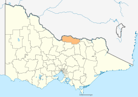 Location in Victoria | |||||||||||||||
| Population | 30,018 (2021)[1] | ||||||||||||||
| • Density | 7.4210/km2 (19.2203/sq mi) | ||||||||||||||
| Established | 1994 | ||||||||||||||
| Gazetted | 18 November 1994[2] | ||||||||||||||
| Area | 4,045 km2 (1,561.8 sq mi)[1] | ||||||||||||||
| Council seat | Cobram | ||||||||||||||
| Region | Northern Victoria | ||||||||||||||
| State electorate(s) |
| ||||||||||||||
| Federal division(s) |
| ||||||||||||||
| Website | Moira Shire Council | ||||||||||||||
| |||||||||||||||
It includes the towns of Cobram, Nathalia, Numurkah, Tungamah and Yarrawonga. It was formed in 1994 from the amalgamation of the Shire of Cobram, Shire of Nathalia, Shire of Numurkah, and parts of the Shire of Tungamah and Shire of Yarrawonga.[2]
The Shire is governed and administered by the Moira Shire Council; its seat of local government and administrative centre is located at the council headquarters in Cobram, it also has a service centre located in Yarrawonga. The Shire is named after the county of Moira, of which the LGA occupies the northern part.
Council
Current composition
The council is composed of nine councillors elected to represent an unsubdivided municipality.[3]
| Ward | Councillor | Notes | |
|---|---|---|---|
| Unsubdivided | John Bietzel | ||
| Julie Brooks | |||
| Edward Cox | |||
| Peter Elliott | |||
| Judy Heather | |||
| Peter Lawless | |||
| Wayne Limbrick | |||
| Peter Mansfield | |||
| Libro Mustica | Mayor 2021/22 | ||
Administration and governance
The council meets in various locations around the Shire. It also provides customer services at both its administrative centre in Cobram and its service centre in Yarrawonga.
Main towns in shire
In 2021 census the shire had a population of 30,522.
| Population | ||
| Locality | 2016 | 2021 |
| Almonds | 26 | 31 |
| Barmah | 282 | 229 |
| Bathumi | 62 | 76 |
| Bearii | 145 | 167 |
| Boomahnoomoonah | 22 | 14 |
| Boosey | 105 | 108 |
| Boweya North | 43 | 42 |
| Bundalong | 428 | 512 |
| Bundalong South | 51 | 42 |
| Burramine | 197 | 241 |
| Burramine South | 24 | 24 |
| Cobram | 6,014 | 6,148 |
| Cobram East | 242 | 232 |
| Drumanure | 41 | 41 |
| Population | ||
| Locality | 2016 | 2021 |
| Esmond | 9 | 17 |
| Invergordon | 610 | 601 |
| Kaarimba | 85 | 93 |
| Katamatite | 402 | 453 |
| Katamatite East | 35 | 30 |
| Katunga | 996 | 1,025 |
| Koonoomoo | 296 | 305 |
| Kotupna | 105 | 132 |
| Lake Rowan | 66 | 70 |
| Lower Moira | 25 | 30 |
| Marungi | 111 | 98 |
| Muckatah | 213 | 170 |
| Mundoona | 119 | 138 |
| Mywee | 14 | 20 |
| Population | ||
| Locality | 2016 | 2021 |
| Naring | 120 | 122 |
| Nathalia | 1,880 | 1,982 |
| Numurkah | 4,477 | 4,604 |
| Peechelba | 184 | 177 |
| Pelluebla | 33 | 29 |
| Picola | 207 | 206 |
| Picola West | 9 | 14 |
| St James | 132 | 123 |
| Strathmerton | 1,052 | 1,072 |
| Telford | 24 | 21 |
| Tungamah | 408 | 449 |
| Ulupna | 23 | 17 |
| Waaia | 390 | 420 |
| Waggarandall | 40 | 52 |
| Population | ||
| Locality | 2016 | 2021 |
| Wilby | 166 | 192 |
| Wunghnu | 334 | 326 |
| Yabba North | 101 | 014 |
| Yabba South | 27 | 32 |
| Yalca | 206 | 222 |
| Yarrawonga | 7,930 | 8,661 |
| Yarrawonga South | 15 | 15 |
| Yarroweyah | 548 | 551 |
| Yielima | 87 | 93 |
| Youanmite | 59 | 56 |
| Youarang | 39 | 34 |
| Yundool | 44 | 52 |
See also
- List of localities (Victoria)
- List of places on the Victorian Heritage Register in the Shire of Moira
References
- "Moira Shire Council Annual Report 2020/21" (PDF). Moira Shire Council. 30 June 2021. Retrieved 27 November 2021.
- Victoria Government Gazette – Online Archive (1837–1997). "S87 of 1994: Order estg (Part 11) the Shire of Moira". State Library of Victoria. State Government of Victoria (published 18 November 1994). p. 4. Retrieved 10 January 2014.
- Local Government in Victoria. "Moira Shire Council". Department of Transport, Planning and Local Infrastructure. State Government of Victoria. Retrieved 10 January 2014.
External links
- Moira Shire Council official website
- Metlink local public transport map
- Link to Land Victoria interactive maps
This Australian government-related article is a stub. You can help Wikipedia by expanding it. |
This article about a location in Hume (region) is a stub. You can help Wikipedia by expanding it. |
На других языках
[de] Moira Shire
-35.966666666667145.65 Moira Shire ist ein lokales Verwaltungsgebiet (LGA) im australischen Bundesstaat Victoria. Das Gebiet ist 4046,6 km² groß und hat etwa 29.000 Einwohner.[1]- [en] Shire of Moira
Другой контент может иметь иную лицензию. Перед использованием материалов сайта WikiSort.org внимательно изучите правила лицензирования конкретных элементов наполнения сайта.
WikiSort.org - проект по пересортировке и дополнению контента Википедии