world.wikisort.org - Australia
Lachlan Shire is a local government area in the Central West region of New South Wales, Australia. The Shire is located adjacent to the Lachlan River, the Lachlan Valley Way and the Broken Hill railway line.
| Lachlan Shire New South Wales | |||||||||||||||
|---|---|---|---|---|---|---|---|---|---|---|---|---|---|---|---|
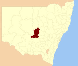 Location in New South Wales | |||||||||||||||
| Coordinates | 33°03′S 147°09′E | ||||||||||||||
| Population | |||||||||||||||
| • Density | 0.41368/km2 (1.07142/sq mi) | ||||||||||||||
| Area | 14,973 km2 (5,781.1 sq mi) | ||||||||||||||
| Mayor | John Medcalf (Unaligned) | ||||||||||||||
| Council seat | Condobolin[3] | ||||||||||||||
| Region | Central West | ||||||||||||||
| State electorate(s) | Barwon | ||||||||||||||
| Federal division(s) | Parkes | ||||||||||||||
| Website | Lachlan Shire | ||||||||||||||
| |||||||||||||||
The largest town and council seat is Condobolin. The Shire also includes the towns and villages of Albert, Burcher, Fifield, Lake Cargelligo, Tottenham and Tullibigeal.
The Mayor of Lachlan Shire Council is Cr. John Medcalf, who is unaligned with any political party.
Heritage listings
The Lachlan Shire has a number of heritage-listed sites, including:
- Condobolin, McDonnell Street: All Saints' Anglican Church, Condobolin[4]
Council
Current composition and election method
Lachlan Shire Council is composed of ten Councillors elected proportionally as five separate wards, each electing two Councillors. All Councillors are elected for a fixed four-year term of office. The Mayor is elected by the Councillors at the first meeting of the council. The most recent election was held on 10 September 2016 and the makeup of the council is as follows:[5][6][7][8][9]
| Party | Councillors | |
|---|---|---|
| Independent and Unaligned | 10 | |
| Total | 10 | |
The current Council, elected in 2016, in order of election by ward, is:
| Ward | Councillor | Party | Notes | |
|---|---|---|---|---|
| A Ward[5] | John Medcalf | Unaligned | Mayor[10] | |
| Brian Nelson | Unaligned | |||
| B Ward[6] | Melissa Rees | Independent | ||
| Melissa Blewett | Independent | |||
| C Ward[7] | Dave Carter | Independent | ||
| Peter Harris | Unaligned | |||
| D Ward[8] | Max Frankel | Unaligned | ||
| John Ridley | Independent | |||
| E Ward[9] | Mark Hall | Independent | ||
| Paul Phillips | Independent | Deputy Mayor[10] | ||
References
- Australian Bureau of Statistics (27 June 2017). "Lachlan (A)". 2016 Census QuickStats. Retrieved 8 December 2017.
- "3218.0 – Regional Population Growth, Australia, 2017-18". Australian Bureau of Statistics. 27 March 2019. Retrieved 27 March 2019. Estimated resident population (ERP) at 30 June 2018.
- "Lachlan Shire Council". Division of Local Government. Retrieved 28 November 2006.
- "All Saints Anglican Church". New South Wales State Heritage Register. Office of Environment & Heritage. H01787. Retrieved 18 May 2018.
- "Lachlan Shire Council - A Ward". Local Government Elections 2016. Electoral Commission of New South Wales. 17 September 2016. Retrieved 3 November 2016.
- "Lachlan Shire Council - B Ward". Local Government Elections 2016. Electoral Commission of New South Wales. 17 September 2016. Retrieved 3 November 2016.
- "Lachlan Shire Council - C Ward". Local Government Elections 2016. Electoral Commission of New South Wales. 17 September 2016. Retrieved 3 November 2016.
- "Lachlan Shire Council - D Ward". Local Government Elections 2016. Electoral Commission of New South Wales. 17 September 2016. Retrieved 3 November 2016.
- "Lachlan Shire Council - E Ward". Local Government Elections 2016. Electoral Commission of New South Wales. 17 September 2016. Retrieved 3 November 2016.
- "Lachlan Shire Council". lachlan.nsw.gov.au. Retrieved 3 November 2016.
External links
![]() Media related to Lachlan Shire at Wikimedia Commons
Media related to Lachlan Shire at Wikimedia Commons
This Central West geography article is a stub. You can help Wikipedia by expanding it. |
На других языках
[de] Lachlan Shire
-33.05147.15 Lachlan Shire ist ein lokales Verwaltungsgebiet (LGA) im australischen Bundesstaat New South Wales. Das Gebiet ist 14.968,3 km² groß und hat etwa 6.100 Einwohner.[1]- [en] Lachlan Shire
Другой контент может иметь иную лицензию. Перед использованием материалов сайта WikiSort.org внимательно изучите правила лицензирования конкретных элементов наполнения сайта.
WikiSort.org - проект по пересортировке и дополнению контента Википедии