world.wikisort.org - USA
Watertown is a city in and the county seat of Codington County, South Dakota, United States.[6] Watertown is home to the Redlin Art Center which houses many of the original art works produced by Terry Redlin, one of America's most popular wildlife artists. Watertown is located between Pelican Lake and Lake Kampeska, from which Redlin derived inspiration for his artwork.
Watertown, South Dakota | |
|---|---|
City | |
 Intersection of Interstate 29 and Highway 212: The Redlin Art Center | |
| Nickname: South Dakota's Rising Star | |
 Location in Codington County and the state of South Dakota | |
| Coordinates: 44°54′12″N 97°7′14″W | |
| Country | United States |
| State | South Dakota |
| County | Codington |
| Founded | 1879[1] |
| Incorporated | 1885[2] |
| Government | |
| • Type | Mayor–council |
| • Body | Watertown City Council |
| • Mayor | Ried Holien |
| Area | |
| • City | 26.34 sq mi (68.23 km2) |
| • Land | 18.37 sq mi (47.57 km2) |
| • Water | 7.98 sq mi (20.66 km2) |
| Elevation | 1,732 ft (528 m) |
| Population (2020)[4] | |
| • City | 22,655 |
| • Density | 1,233.46/sq mi (476.25/km2) |
| • Metro | 34,682 (US: 375th) |
| Time zone | UTC-6 (CST) |
| • Summer (DST) | UTC-5 (CDT) |
| ZIP code | 57201 |
| Area code | 605 |
| FIPS code | 46-69300 |
| GNIS feature ID | 1258841[5] |
| Website | watertownsd.us |
The population was 22,655 at the 2020 census,[7] making Watertown the 5th largest city in South Dakota. It is also the principal city of the Watertown Micropolitan Statistical Area, which includes all of Codington and Hamlin counties. Watertown also is home to the Bramble Park Zoo. Watertown's residential real estate is considered the most expensive in South Dakota for cities of its size; the median price for a home in Watertown is approximately $200,000.[8]
Geography
Watertown is located at 44°54′12″N 97°7′14″W (44.903433, -97.120437),[9] along the Big Sioux River.[10]
According to the United States Census Bureau, the city has a total area of 25.04 square miles (64.85 km2), of which 17.45 square miles (45.20 km2) is land and 7.59 square miles (19.66 km2) is water.[11] Watertown sits on the Big Sioux River and two major lakes, Pelican Lake and Lake Kampeska. Most of Watertown also sits upon a short plateau. The elevation at Watertown Regional Airport is 1,745 feet.
Watertown has been assigned the ZIP code 57201 and the FIPS place code 69300.
History
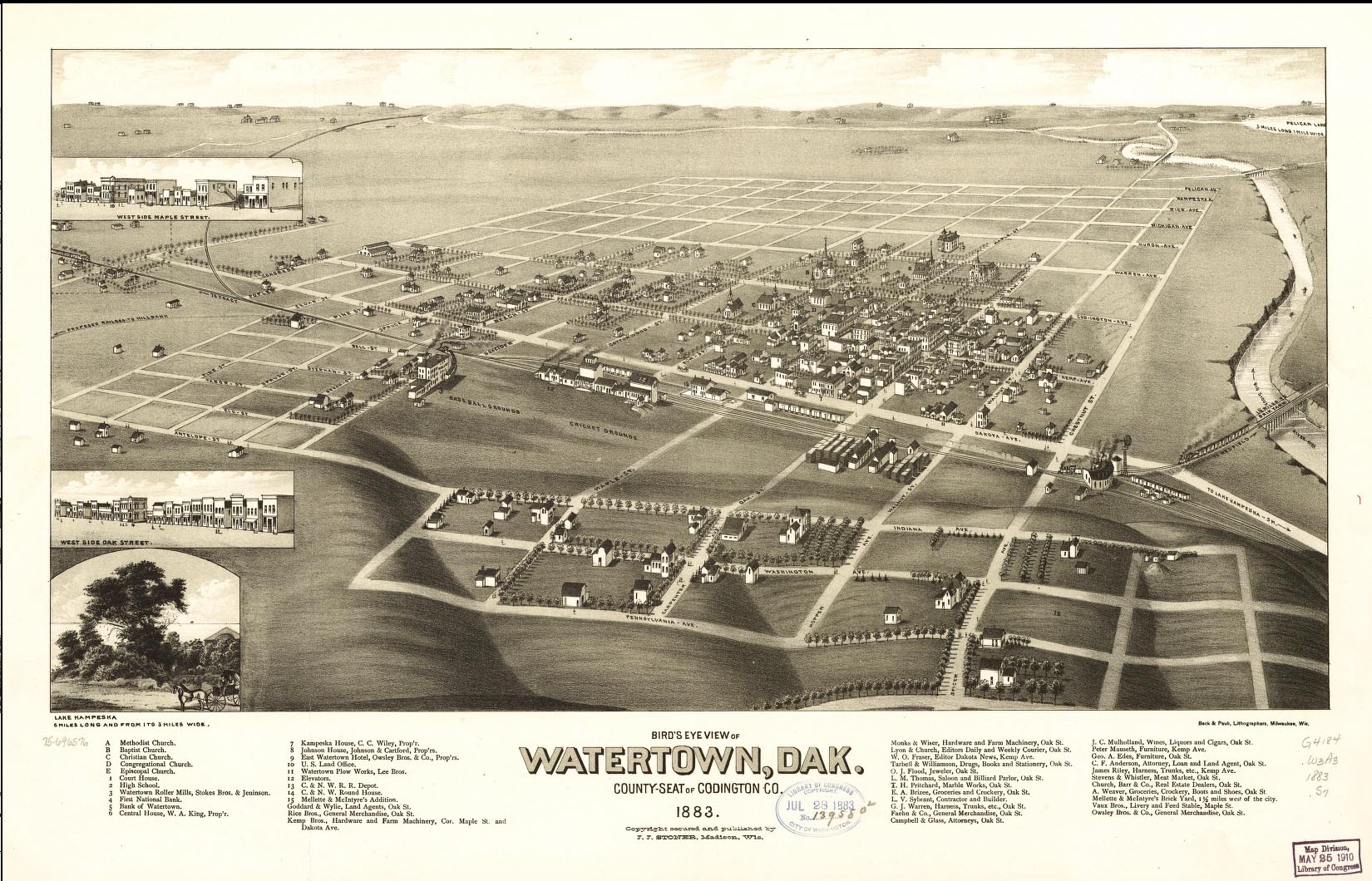
Watertown was founded in 1879 as a rail terminus when the Chicago & Northwestern Railroad reactivated part of a line it had constructed to Lake Kampeska.[1][12] Despite the prominence of rivers and lakes in the area, the city was named after Watertown, New York, the hometown of brothers John E. Kemp and Oscar P. Kemp, two of the city's founders. The town's name was originally planned to be named Kampeska.[1]
During the 1880s, Watertown prospered as a transportation hub after the railroads had been extended farther west. Along with several other cities, Watertown had been a candidate as capital of the new state of South Dakota,[1] although it lost out to the more centrally located Pierre. The city's current newspaper, the Watertown Public Opinion, began publishing in 1887.[1]
In the mid-20th century, Interstate 29 was constructed through eastern South Dakota.[13] The route included a slight bend to bring the interstate closer to Watertown.[13] The interstate's construction has been a major economic benefit to the larger communities along its route, including Watertown.[13]
Climate
In the last decades the climate is configured as hot-summer humid continental climate (Köppen: Dfa), although it had a warm-summer previously (Dfb). Although it is a humid city it is relatively dry for its climatic category, due to its position in the Great Plains, which still provides an even greater thermal amplitude, especially in the higher values.[14]
| Climate data for Watertown Regional Airport, South Dakota (1991−2020 normals, extremes 1893−present) | |||||||||||||
|---|---|---|---|---|---|---|---|---|---|---|---|---|---|
| Month | Jan | Feb | Mar | Apr | May | Jun | Jul | Aug | Sep | Oct | Nov | Dec | Year |
| Record high °F (°C) | 65 (18) |
66 (19) |
82 (28) |
95 (35) |
106 (41) |
107 (42) |
110 (43) |
105 (41) |
104 (40) |
91 (33) |
78 (26) |
69 (21) |
110 (43) |
| Average high °F (°C) | 21.4 (−5.9) |
25.9 (−3.4) |
38.6 (3.7) |
54.0 (12.2) |
66.9 (19.4) |
76.8 (24.9) |
82.0 (27.8) |
79.5 (26.4) |
71.6 (22.0) |
56.2 (13.4) |
39.8 (4.3) |
26.3 (−3.2) |
53.2 (11.8) |
| Daily mean °F (°C) | 12.2 (−11.0) |
16.3 (−8.7) |
29.1 (−1.6) |
42.8 (6.0) |
55.7 (13.2) |
66.1 (18.9) |
71.0 (21.7) |
68.5 (20.3) |
60.1 (15.6) |
45.7 (7.6) |
30.6 (−0.8) |
17.8 (−7.9) |
43.0 (6.1) |
| Average low °F (°C) | 3.1 (−16.1) |
6.7 (−14.1) |
19.6 (−6.9) |
31.5 (−0.3) |
44.5 (6.9) |
55.4 (13.0) |
60.0 (15.6) |
57.5 (14.2) |
48.6 (9.2) |
35.2 (1.8) |
21.3 (−5.9) |
9.3 (−12.6) |
32.7 (0.4) |
| Record low °F (°C) | −40 (−40) |
−38 (−39) |
−27 (−33) |
−10 (−23) |
16 (−9) |
25 (−4) |
35 (2) |
32 (0) |
9 (−13) |
−2 (−19) |
−20 (−29) |
−37 (−38) |
−40 (−40) |
| Average precipitation inches (mm) | 0.58 (15) |
0.65 (17) |
1.00 (25) |
2.06 (52) |
2.87 (73) |
3.85 (98) |
3.05 (77) |
2.89 (73) |
2.45 (62) |
1.95 (50) |
0.68 (17) |
0.68 (17) |
22.71 (577) |
| Average snowfall inches (cm) | 6.7 (17) |
8.9 (23) |
5.4 (14) |
5.2 (13) |
0.1 (0.25) |
0.0 (0.0) |
0.0 (0.0) |
0.0 (0.0) |
0.0 (0.0) |
1.4 (3.6) |
4.5 (11) |
8.9 (23) |
41.1 (104) |
| Average precipitation days (≥ 0.01 in) | 5.9 | 6.0 | 6.9 | 8.9 | 11.4 | 11.4 | 9.5 | 8.6 | 8.5 | 7.5 | 5.4 | 6.3 | 96.3 |
| Average snowy days (≥ 0.1 in) | 5.6 | 5.9 | 3.5 | 1.9 | 0.0 | 0.0 | 0.0 | 0.0 | 0.0 | 1.1 | 2.6 | 6.0 | 26.6 |
| Source: NOAA[15][16] | |||||||||||||
Demographics
| Historical population | |||
|---|---|---|---|
| Census | Pop. | %± | |
| 1880 | 746 | — | |
| 1890 | 2,672 | 258.2% | |
| 1900 | 3,352 | 25.4% | |
| 1910 | 7,010 | 109.1% | |
| 1920 | 9,400 | 34.1% | |
| 1930 | 10,214 | 8.7% | |
| 1940 | 10,617 | 3.9% | |
| 1950 | 12,699 | 19.6% | |
| 1960 | 14,077 | 10.9% | |
| 1970 | 13,388 | −4.9% | |
| 1980 | 15,649 | 16.9% | |
| 1990 | 17,592 | 12.4% | |
| 2000 | 20,237 | 15.0% | |
| 2010 | 21,482 | 6.2% | |
| 2020 | 22,655 | 5.5% | |
| 2021 (est.) | 22,722 | [17] | 0.3% |
| U.S. Decennial Census[18] 2020 Census[7][4] | |||
The per capita income for the city was $18,994. About 5.7% of families and 9.3% of the population were below the poverty line, including 8.5% of those under age 18 and 11.0% of those age 65 or over.[19]
2010 census
As of the census of 2010, there were 21,482 people, 9,278 households, and 5,563 families residing in the city. The population density was 1,231.3 inhabitants per square mile (475.4/km2). There were 10,050 housing units at an average density of 575.9 per square mile (222.4/km2). The racial makeup of the city was 94.8% White, 0.4% African American, 2.4% Native American, 0.5% Asian, 0.5% from other races, and 1.4% from two or more races. Hispanic or Latino of any race were 1.6% of the population.
There were 9,278 households, of which 29.6% had children under the age of 18 living with them, 45.7% were married couples living together, 10.0% had a female householder with no husband present, 4.3% had a male householder with no wife present, and 40.0% were non-families. 33.0% of all households were made up of individuals, and 12.4% had someone living alone who was 65 years of age or older. The average household size was 2.28 and the average family size was 2.90.
The median age in the city was 36.6 years. 24.2% of residents were under the age of 18; 10.3% were between the ages of 18 and 24; 24.9% were from 25 to 44; 25.2% were from 45 to 64; and 15.4% were 65 years of age or older. The gender makeup of the city was 49.2% male and 50.8% female.
2000 census
As of the census of 2000, there were 20,237 people, 8,385 households, and 5,290 families residing in the city. The population density was 1,328.9 people per square mile (513.0/km2). There were 9,193 housing units at an average density of 603.7 per square mile (233.1/km2). The racial makeup of the city was 96.25% White, 0.14% African American, 1.65% Native American, 0.33% Asian, 0.02% Pacific Islander, 0.71% from other races, and 0.90% from two or more races. Hispanic or Latino of any race were 1.28% of the population. 47.1% were of German, 19.8% Norwegian and 5.9% Irish ancestry. 96.5% spoke English, 1.7% Spanish and 1.1% German as their first language.
There were 8,385 households, out of which 31.9% had children under the age of 18 living with them, 50.6% were married couples living together, 8.8% had a female householder with no husband present, and 36.9% were non-families. 30.5% of all households were made up of individuals, and 11.8% had someone living alone who was 65 years of age or older. The average household size was 2.37 and the average family size was 2.98.
In the city, the population was spread out, with 25.9% under the age of 18, 11.3% from 18 to 24, 27.9% from 25 to 44, 19.9% from 45 to 64, and 15.0% who were 65 years of age or older. The median age was 35 years. For every 100 females, there were 96.6 males. For every 100 females age 18 and over, there were 93.9 males.
Education
Watertown has two institutions providing post-secondary education. Lake Area Technical College is a public technical school classified as a community college, offering degrees in areas such as Agriculture, Nursing, and Welding. There is also a satellite campus of Mount Marty College,[20] a private Catholic school based in Yankton, South Dakota.
Lake Area Technical College received the 2017 Aspen Prize for Community College Excellence, following three previous Finalist-With-Distinction honors in 2011, 2013, and 2015 (bi-annual competition/selection process). The Prize was awarded by the Aspen Institute in March 2017 in Washington, D.C. following an intense data collection process by Aspen officials that included a rigorous review of critical elements of student success including learning, completion, and employment after college.
Watertown has one public high school, Watertown High School, and one private boarding school, Great Plains Lutheran High School, of the Wisconsin Evangelical Lutheran Synod.[21]
Watertown Middle School (7th and 8th grades) is the only public middle school in Watertown. Construction of the Middle School was completed in August 2015. The community's “Prairie Lakes Wellness Center”, opened in 2017, is adjacent to the Middle School. When the Middle School opened in 2015, the prior middle school was completely renovated and became the Intermediate School (5th and 6th grades).
There are multiple elementary schools in Watertown. The five public elementary schools include: Lincoln Elementary, Jefferson Elementary, Roosevelt Elementary, McKinnely Elementary, and Mellette Elementary. Immaculate Conception School is a private Catholic elementary school. St. Martin's Lutheran School is a private Lutheran elementary school of the WELS. Watertown Christian School is a private non-denominational Christian elementary school.
The Watertown Regional Library is the town's main library, located on 6th St. NE, and open every day of the week.
Harmony Hill High School was a Catholic girls boarding school in Watertown from 1967 to 1974.
Points of interest

- Redlin Art Center
- Bramble Park Zoo
- Codington County Heritage Museum
- Mellette House
- Watertown Family Aquatic Center
- Watertown Stadium
- Lake Kampeska
- Pelican Lake
- Watertown Regional Library
Local media
- Newspaper
- The Watertown Public Opinion is the local daily newspaper.
Television
| Channel (Digital) |
Callsign | Network | Owner | Web site |
|---|---|---|---|---|
| 3.1 | KDLO-DT (Satellite of KELO) | CBS | Nexstar Media Group | www |
| 3.2 | KDLO-DT (Satellite of KELO) | MyNetworkTV | Nexstar Media Group | www |
| 7.1 | K32DK-D (Translator of KTTW) | Fox | Independent Communications | www |
| 7.2 | K32DK-D (Translator of KTTW) | This TV | Independent Communications | www |
| 46.1 | K42FI-D (Translator of KDLT) | NBC | Red River Broadcasting | www |
| 46.2 | K42FI-D (Translator of KDLT) | Antenna TV | Red River Broadcasting | www |
AM radio
| AM radio stations | |||||
|---|---|---|---|---|---|
| Frequency | Call sign | Name | Format | Owner | City |
| 950 AM | KWAT | Full-service radio | Alpha Media | Watertown | |
| 1480 AM | KSDR | The Talk of Watertown | Conservative talk radio | Alpha Media | Watertown |
FM radio
| FM radio stations | ||||||
|---|---|---|---|---|---|---|
| Frequency | Call sign | Name | Format | Owner | Target city/market | City of license |
| 89.1 FM | KPGT | Religious | Church Planters of America | Watertown | Watertown | |
| 90.1 FM | K211EC | Christian WJFM-FM translator | Jimmy Swaggart Ministries | Watertown | Watertown | |
| 90.3 FM | KJSD | South Dakota Public Broadcasting | NPR | South Dakota Bureau of Information and Telecommunication | Watertown | Watertown |
| 91.9 FM | K220IT | KNWC-FM | Contemporary Christian | University of Northwestern - St. Paul | Watertown | Watertown |
| 92.9 FM | KSDR-FM | New Country KS93 | Hot Country | Alpha Media | Watertown | Watertown |
| 96.1 FM | KIXX | The Best Mix Kicks 96 | Hot AC | Alpha Media | Watertown | Watertown |
| 96.9 FM | KDLO-FM | 96.9 KDLO Country | Classic Country | Alpha Media | Watertown | Watertown |
| 98.1 FM | KPHR-FM | Star 98.1 | Soft Adult Contemporary | Prairie Winds Broadcasting | Watertown | Ortonville |
| 99.1 FM | KXLG | Soft Adult Contemporary, News/Talk | TMRG Broadcasting, LLC | Watertown | Milbank | |
| 103.5 FM | K278BK | Christian Radio | VCY America | Watertown | Watertown | |
| 104.3 FM | KKSD | 104.3 KKSD | Classic Hits | Alpha Media | Watertown | Milbank |
| 106.3 FM | KPHR | Power 106.3 | Classic Rock | Prairie Winds Broadcasting | Watertown | Ortonville |
Transportation
 Interstate 29-serves Watertown at Exits 177 and 180
 U.S. Highway 81
 U.S. Highway 212
 South Dakota Highway 20
- 20th Avenue South, 20th Avenue Southeast, and 29th Street Southeast-Alternate City Truck Route around the south side of Watertown.
- 448th Avenue and North Lake Drive-Former South Dakota Highway 139; runs along the west side of Lake Kampeska.
Watertown also has one airport, Watertown Regional Airport, served by two commercial airlines, and local bus service provided by the Watertown Area Transit Corporation.
Notable people
- Cleveland Abbott (Tuskegee Institute) Multiple hall of fame coach and educator
- Sylvia Bacon (born 1931), Judge of the Superior Court, District of Columbia
- Nancy Turbak Berry, trial attorney and South Dakota state senator
- Stephen Foster Briggs (1885-1976), founder Briggs & Stratton Corporation
- John Hamre (born 1950), Deputy Secretary of Defense and international studies specialist
- Fred H. Hildebrandt, U.S. Representative from South Dakota
- Wendell Hurlbut (1918-2011), amusement park designer
- J. A. Jance (born 1944), writer
- Charles B. Kornmann (born 1937), federal judge on United States District Court for the District of South Dakota
- Jake Krull (1938-2016), U.S. General and South Dakota state senator
- George R. Mather, General in the U.S. Army, Commander in Chief, United States Southern Command (USCINCSO) from 1969 to 1971
- Arthur C. Mellette, (1842-1896), last Dakota Territorial Governor and first Governor of the State of South Dakota.
- Kristi Noem, (born 1971), current Governor of the State of South Dakota.[22][23]
- Hope A. Olson, author and professor in the field of information studies
- Henry Roberts Pease (1837-1907) Civil War veteran and United States Senator from Mississippi
- Lee Raymond, (born 1938), chemical engineer and long-time Chairman and CEO, Exxon Corporation and ExxonMobil, born and attended primary and secondary school in Watertown
- Terry Redlin (1937-2016), wildlife artist and Redlin Art Center
- Bob Scholtz (born 1937), American football player
- Joseph Schull (6 February 1906 – 19 May 1980), Canadian playwright and historian
- Ramona Solberg (1921-2005), jeweler
- Lee Schoenbeck (born 1958), lawyer and current President Pro Tempore of the State Senate
- Neal Tapio (born 1970), businessman and former Trump presidential campaign director for South Dakota
- Timmy Williams (born 1981), American comedian of The Whitest Kids U' Know
- Roger Zwieg (1942-2015), NASA test pilot and flight instructor
Notable visitors
Former President Barack Obama has visited the city twice, first in 2008 during his presidential campaign, and again on May 8, 2015, to address the graduating class of 2015 from Lake Area Technical College.
Major employers
According to the City's 2018 Comprehensive Annual Financial Report,[24][25] the largest employers in the city are:
| Employer | Sector | Number of Employees | As of | Notes |
|---|---|---|---|---|
| Watertown School District | Education | 776 | June 2018 | |
| Prairie Lakes Health System | Healthcare | 683 | June 2018 | |
| Terex Utilities | Manufacturing | 634 | June 2018 | |
| Hy-Vee | Retail | 450 | June 2018 | Mostly part-time |
| Premier Bankcard | Lending | 367 | June 2018 | |
| City of Watertown | Government | 336 | June 2018 | |
| Worthington Industries | Manufacturing | 309 | June 2018 | |
| Walmart | Retail | 300 | July 2017 | |
| Dakota Bodies | Manufacturing | 285 | June 2018 | |
| Jenkins Living Center | Healthcare | 274 | June 2018 | |
| OEM Worldwide/Sparton | Manufacturing | 272 | May 2017 | |
| Spartronics | Manufacturing | 253 | June 2018 | |
| Dakota Sioux Casino | Entertainment | 215 | November 2016 | |
| Lake Area Technical College | Education | 211[26] | May 2017 | |
| Target | Retail | 85 | July 2017 |
References
- Hasselstrom, p. 29.
- "SD Towns" (PDF). South Dakota State Historical Society. Retrieved February 17, 2010.
- "ArcGIS REST Services Directory". United States Census Bureau. Retrieved October 15, 2022.
- "Census Population API". United States Census Bureau. Retrieved Oct 15, 2022.
- "US Board on Geographic Names". United States Geological Survey. October 25, 2007. Retrieved January 31, 2008.
- "Find a County". National Association of Counties. Retrieved June 7, 2011.
- "Explore Census Data". Explore Census Data. United States Census Bureau. Retrieved August 16, 2022.
- "South Dakota Homes For Sale By City". South Dakota Real Estate Trends. RealEstate.com. Retrieved January 28, 2013.
- "US Gazetteer files: 2010, 2000, and 1990". United States Census Bureau. February 12, 2011. Retrieved April 23, 2011.
- DeLorme (2001). South Dakota Atlas & Gazetteer. Yarmouth, Maine: DeLorme. ISBN 0-89933-330-3
- "US Gazetteer files 2010". United States Census Bureau. Archived from the original on July 2, 2012. Retrieved June 21, 2012.
- Thompson (ed.), p. 173.
- Schell, p. 333.
- "Watertown, South Dakota Köppen Climate Classification (Weatherbase)". Weatherbase. Retrieved July 19, 2019.
- "NowData - NOAA Online Weather Data". National Oceanic and Atmospheric Administration. Retrieved October 13, 2021.
- "Station: Watertown RGNL AP, SD". U.S. Climate Normals 2020: U.S. Monthly Climate Normals (1991-2020). National Oceanic and Atmospheric Administration. Retrieved October 13, 2021.
- "City and Town Population Totals: 2020-2021". United States Census Bureau. June 24, 2022. Retrieved August 16, 2022.
- United States Census Bureau. "Census of Population and Housing". Retrieved September 23, 2013.
- Watertown, South Dakota: Now. Watertown Area Chamber of Commerce and Convention and Visitors Bureau, 2006
- "Watertown Campus". Retrieved February 18, 2011.
- "Great Plains Lutheran High School".
- "Retro Member details". Biographical Directory of the U.S. Congress. Retrieved November 17, 2021.
- "NOEM, Kristi". US House of Representatives: History, Art & Archives. Retrieved November 17, 2021.
- "City of Watertown 2018 Comprehensive Annual Financial Report" (PDF). August 16, 2022. p. 10.
- "Top Employers". Watertown Works. June 2018. Retrieved August 16, 2022.
- "LATI Staff". Retrieved June 1, 2017.
Bibliography
- Hasselstrom, Linda M. (1994). Roadside History of South Dakota. Missoula, MT: Mountain Press Publishing Company. ISBN 0-87842-262-5.
- Schell, Herbert S. (2004). History of South Dakota. Pierre, SD: South Dakota State Historical Society Press. ISBN 0-9715171-3-4.
- Thompson, Harry F. (ed.) (2009). A New South Dakota History (Second ed.). Sioux Falls, SD: Center for Western Studies - Augustana College. ISBN 978-0-931170-00-3.
{{cite book}}:|author=has generic name (help)
External links
- Official website
- Watertown Area Chamber of Commerce
- Watertown Public Opinion - local newspaper
- Watertown Regional Library Website
- School District Website
Municipalities and communities of Codington County, South Dakota, United States | ||
|---|---|---|
County seat: Watertown | ||
| City | 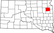 | |
| Towns | ||
| CDP | ||
| Other communities |
| |
| Indian reservation |
| |
| Footnotes | ‡This populated place also has portions in an adjacent county or counties | |
| ||
Authority control | |
|---|---|
| General | |
| National libraries | |
| Other |
|
На других языках
[de] Watertown (South Dakota)
Watertown ist eine Stadt im US-Bundesstaat South Dakota und Verwaltungssitz (County Seat) des Codington County.- [en] Watertown, South Dakota
[ru] Уотертаун (Южная Дакота)
Уотертаун — город и окружной центр округа Кодингтон в Южной Дакоте. Население 21 482 (на 2010 год) — пятое место в штате. В Уотертауне находится художественная галерея Редлина, содержащая большое количество работ американского художника Терри Редлина, известного изображением дикой природы.Другой контент может иметь иную лицензию. Перед использованием материалов сайта WikiSort.org внимательно изучите правила лицензирования конкретных элементов наполнения сайта.
WikiSort.org - проект по пересортировке и дополнению контента Википедии