world.wikisort.org - USA
Tunitas, California was a small unincorporated community in San Mateo County. It was originally located on State Route 1 until that state route was moved to the west. It was also renamed Lobitos.[1]
Tunitas, California | |
|---|---|
Ghost town | |
 Tunitas, California Location within the state of California | |
| Coordinates: 37°22′59″N 122°23′57″W | |
| Country | United States |
| State | California |
| County | San Mateo |
| Time zone | UTC-8 (Pacific (PST)) |
| • Summer (DST) | UTC-7 (PDT) |
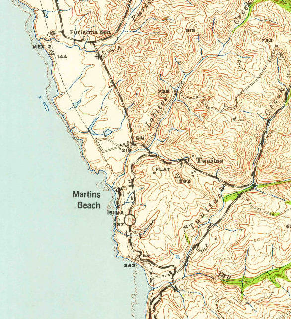


Arroyo de las Tunitas is shown on the diseños, about 1839, of the San Gregorio and Canada Verde grants.[2] The name means “A small bush…grows super-abundant at and near its mouth, and its fruit is known to the present generation as sea apples.”[3]
References
- http://bard.wr.usgs.gov/historical/jpg/halfmoonbay1940a.jpg; http://bard.wr.usgs.gov/historical/jpg/halfmoonbay1961a.jpg
- Gudde, Erwin G. (1998). California place names : the origin and etymology of current geographical names (4th ed., rev. and enl. ed.). Berkeley: University of California Press. p. 403. ISBN 0520213165.
- "Funny name…What does Tunitas mean?…… | Pescadero Memories".
Municipalities and communities of San Mateo County, California, United States | ||
|---|---|---|
County seat: Redwood City | ||
| Cities and towns |  | |
| CDPs |
| |
| Unincorporated communities |
| |
| Ghost towns | ||
| ||
San Francisco Bay Area | ||
|---|---|---|
| Bodies of water |
|  |
| Counties |
| |
| Major cities | ||
| Cities and towns 100k–250k | ||
| Cities and towns 50k–99k | ||
| Cities and towns 25k–50k | ||
| Cities and towns 10k–25k |
| |
| Sub-regions |
| |
| ||
Текст в блоке "Читать" взят с сайта "Википедия" и доступен по лицензии Creative Commons Attribution-ShareAlike; в отдельных случаях могут действовать дополнительные условия.
Другой контент может иметь иную лицензию. Перед использованием материалов сайта WikiSort.org внимательно изучите правила лицензирования конкретных элементов наполнения сайта.
Другой контент может иметь иную лицензию. Перед использованием материалов сайта WikiSort.org внимательно изучите правила лицензирования конкретных элементов наполнения сайта.
2019-2026
WikiSort.org - проект по пересортировке и дополнению контента Википедии
WikiSort.org - проект по пересортировке и дополнению контента Википедии