world.wikisort.org - USA
Riverview is a city in Wayne County in the U.S. state of Michigan. The population was 12,486 at the 2010 census.[4]
Riverview, Michigan | |
|---|---|
City | |
| City of Riverview | |
 Riverview City Hall | |
 Location within Wayne County | |
 Riverview Location within the state of Michigan  Riverview Location within the United States | |
| Coordinates: 42°10′30″N 83°11′18″W | |
| Country | |
| State | |
| County | |
| Incorporated | 1923 (village) 1959 (city) |
| Government | |
| • Type | Mayor–council |
| • Mayor | Andrew Swift |
| • Mayor pro tem | Lynn Blanchette |
| Area | |
| • City | 4.67 sq mi (12.09 km2) |
| • Land | 4.57 sq mi (11.85 km2) |
| • Water | 0.09 sq mi (0.24 km2) |
| Elevation | 600 ft (183 m) |
| Population (2020) | |
| • City | 12,490 |
| • Density | 2,730.65/sq mi (1,054.35/km2) |
| • Metro | 4,285,832 (Metro Detroit) |
| Time zone | UTC-5 (EST) |
| • Summer (DST) | UTC-4 (EDT) |
| ZIP code(s) | 48192 (Wyandotte) 48193 |
| Area code | 734 |
| FIPS code | 26-68880[2] |
| GNIS feature ID | 0636018[3] |
| Website | Official website |
Riverview is a suburb of Metro Detroit about 6 miles (9.7 km) south of the southern border of Detroit along the Detroit River. Riverview was incorporated as a village within Monguagon Township in 1923 and later incorporated as a city in 1959.
History
The August 9, 1812 Battle of Monguagon between Americans and a British-Indian coalition took place in today's Riverview. Native Americans were led by the famous Shawnee warrior Tecumseh, who was wounded in the engagement. The Americans gained a tactical victory at Monguagon but suffered a strategic defeat when US forces returned to Detroit after the fight without reopening their supply line to Ohio. Much of the location remains undeveloped in a green area bounded by Pennsylvania Road to the north, Colvin Street to the south, Electric Avenue to the east, and Vreeland Park to the west, which is also part of the battlefield.
In 1950, Riverview only stretched as far west as the western end of Trenton's two northern boundaries. The rest of what is today Riverview was still part of the unincorporated Monguagon Township at that point.[5] In the 1950s and 1960s, during the Cold War, the Department of Defense (through the United States Army) operated Nike missile launch site D-54 on the site of what is now Young Patriot's Park. The IFC (integrated fire control) site was on the site of what is now Rivergate Nursing Home and Terrace.[6]
Geography
According to the United States Census Bureau, the city has a total area of 4.48 square miles (11.60 km2), of which 4.39 square miles (11.37 km2) is land and 0.09 square miles (0.23 km2) is water.[7]
Demographics
| Historical population | |||
|---|---|---|---|
| Census | Pop. | %± | |
| 1930 | 743 | — | |
| 1940 | 804 | 8.2% | |
| 1950 | 1,432 | 78.1% | |
| 1960 | 7,237 | 405.4% | |
| 1970 | 11,342 | 56.7% | |
| 1980 | 14,569 | 28.5% | |
| 1990 | 13,894 | −4.6% | |
| 2000 | 13,272 | −4.5% | |
| 2010 | 12,486 | −5.9% | |
| 2020 | 12,490 | 0.0% | |
| U.S. Decennial Census[8] | |||
2010 census
As of the census[9] of 2010, there were 12,486 people, 5,163 households, and 3,307 families living in the city. The population density was 2,844.2 inhabitants per square mile (1,098.2/km2). There were 5,520 housing units at an average density of 1,257.4 per square mile (485.5/km2). The racial makeup of the city was 93.0% White, 3.1% African American, 0.4% Native American, 1.6% Asian, 0.5% from other races, and 1.3% from two or more races. Hispanic or Latino of any race were 4.1% of the population.
There were 5,163 households, of which 27.3% had children under the age of 18 living with them, 46.4% were married couples living together, 13.1% had a female householder with no husband present, 4.5% had a male householder with no wife present, and 35.9% were non-families. 31.6% of all households were made up of individuals, and 17.2% had someone living alone who was 65 years of age or older. The average household size was 2.31 and the average family size was 2.90.
The median age in the city was 45.4 years. 19.6% of residents were under the age of 18; 8.6% were between the ages of 18 and 24; 21.3% were from 25 to 44; 27.9% were from 45 to 64; and 22.6% were 65 years of age or older. The gender makeup of the city was 46.4% male and 53.6% female.
2000 census
As of the census[2] of 2000, there were 13,272 people, 5,352 households, and 3,569 families living in the city. The population density was 3,012.6 per square mile (1,162.0/km2). There were 5,532 housing units at an average density of 1,255.7 per square mile (484.3/km2). The racial makeup of the city was 94.13% White, 2.11% African American, 0.43% Native American, 1.88% Asian, 0.02% Pacific Islander, 0.32% from other races, and 1.12% from two or more races. Hispanic or Latino of any race were 2.46% of the population.
Of the 5,352 households, 27.9% had children under the age of 18 living with them, 53.1% were married couples living together, 10.8% had a female householder with no husband present, and 33.3% were non-families. 29.1% of all households were made up of individuals, and 15.0% had someone living alone who was 65 years of age or older. The average household size was 2.38 and the average family size was 2.95.
The city's population was spread out, with 21.3% under the age of 18, 8.2% aged 18 to 24, 25.7% aged 25 to 44, 25.0% aged 45 to 64, and 19.7% who were 65 years of age or older. The median age was 42 years. For every 100 females, there were 87.3 males. For every 100 females age 18 and over, there were 82.5 males.
The median income for a household in the city was $47,623, and the median income for a family was $61,007. Males had a median income of $51,944 versus $31,295 for females. The per capita income for the city was $25,460. About 3.0% of families and 4.7% of the population were below the poverty line, including 3.4% of those under age 18 and 5.2% of those age 65 or over.
Education
Public schools
The Riverview Community School District operates five public schools. There are six schools located in Riverview:
- Riverview Community High School
- Seitz Middle School
- Forest Elementary School
- Huntington Elementary School
- Memorial Elementary School
Catholic schools
There is also a private Catholic high school named Gabriel Richard Catholic High School, located at Pennsylvania and McCann Street.
Transportation
Major roadways
 I-75 runs south–north about one mile (1.6 km) west of the city limits of Riverview and is accessible via exits 34A Dix–Toledo Road and 34B Sibley Road.
 M-85, known locally as Fort Street, runs south–north through the center of Riverview.
- West Jefferson Avenue runs south–north along the easternmost edge of Riverview along the Detroit River.
Bridges
- The Wayne County Bridge is a toll bridge that connects West Jefferson Avenue via Bridge Road to the island of Grosse Ile.
Notable people
- Lloyd Carr, former University of Michigan head football coach[10]
- Bob Guiney, The Bachelor contestant
- Bill McCartney, former University of Colorado head football coach, founder of Promise Keepers
- Derek St. Holmes, vocalist for Ted Nugent
- Woody Widenhofer, former Pittsburgh Steelers assistant football coach and former collegiate head coach
Images
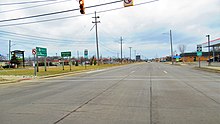 Looking north along Fort Street
 Riverview Police Department
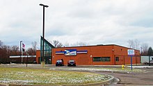 U.S. post office in Riverview
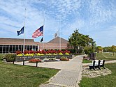 Riverview Veterans Memorial Library


References
- "2020 U.S. Gazetteer Files". United States Census Bureau. Retrieved May 21, 2022.
- "U.S. Census website". United States Census Bureau. Retrieved 2008-01-31.
- "US Board on Geographic Names". United States Geological Survey. 2007-10-25. Retrieved 2008-01-31.
- "Race, Hispanic or Latino, Age, and Housing Occupancy: 2010 Census Redistricting Data (Public Law 94-171) Summary File (QT-PL), Riverview city, Michigan". United States Census Bureau. Retrieved September 7, 2011.
- 1950 Census. Population Vol. 1. pp. 22–32
- "D-54 - Riverview/Wyandotte - The Nike Detroit - Cleveland Defense Area Website". tripod.com.
- "US Gazetteer files 2010". United States Census Bureau. Archived from the original on 2012-01-25. Retrieved 2012-11-25.
- "Census of Population and Housing". Census.gov. Retrieved June 4, 2015.
- "U.S. Census website". United States Census Bureau. Retrieved 2012-11-25.
- "Coaches feel the intensity." The Detroit News. October 30, 2003. Retrieved on October 29, 2009.
External links
Downriver communities – Wayne County, Michigan | ||
|---|---|---|
| Cities | 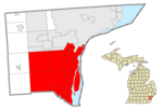 | |
| Charter townships | ||
| Civil township | ||
| Unincorporated communities |
| |
| Footnotes | ‡This populated place also has portions in an adjacent county or counties | |
Municipalities and communities of Wayne County, Michigan, United States | ||
|---|---|---|
County seat: Detroit | ||
| Cities |
|  |
| Charter townships | ||
| Civil townships | ||
| Unincorporated communities |
| |
| Footnotes | ‡This populated place also has portions in an adjacent county or counties | |
| ||
Metro Detroit | ||
|---|---|---|
| Topics |
|  |
| Detroit |
| |
| Municipalities over 80,000 | ||
| Municipalities 40,000 to 80,000 | ||
| Cultural enclaves |
| |
| Satellite cities | ||
| Counties in MSA | ||
| Counties in CSA | ||
| ||
| Authority control |
|
|---|
На других языках
[de] Riverview (Wayne County)
Riverview ist eine Stadt im Wayne County von Michigan in den Vereinigten Staaten. Riverview ist ein Vorort von Detroit und Teil der Metro Detroit. Laut dem United States Census Bureau hat die Stadt eine Gesamtfläche von 12,1 km² mit 12.032 Einwohnern im Jahr 2019.- [en] Riverview, Michigan
Другой контент может иметь иную лицензию. Перед использованием материалов сайта WikiSort.org внимательно изучите правила лицензирования конкретных элементов наполнения сайта.
WikiSort.org - проект по пересортировке и дополнению контента Википедии