world.wikisort.org - USA
Brownstown Charter Township is a charter township in Wayne County in the U.S. state of Michigan. The population was 30,627 at the 2010 census. Brownstown was established in 1827, a decade prior to Michigan's Admission to the Union.
Brownstown Township, Michigan | |
|---|---|
Charter township | |
| Charter Township of Brownstown | |
 Brownstown Charter Township Offices | |
 Flag  Seal | |
| Motto: "Where The Future Looks Brighter"[1] | |
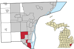 Location within Wayne County | |
 Brownstown Township Location within the State of Michigan  Brownstown Township Location within the United States | |
| Coordinates: 42°07′34″N 83°15′26″W | |
| Country | |
| State | |
| County | |
| Established | 1827 |
| Government | |
| • Supervisor | Edward Smith |
| • Clerk | Maureen Brinker |
| Area | |
| • Charter township | 30.64 sq mi (79.36 km2) |
| • Land | 22.19 sq mi (57.47 km2) |
| • Water | 8.45 sq mi (21.89 km2) |
| Elevation | 584 ft (178 m) |
| Population (2010) | |
| • Charter township | 30,627 |
| • Density | 1,380.2/sq mi (532.9/km2) |
| • Metro | 4,285,832 (Metro Detroit) |
| Time zone | UTC-5 (EST) |
| • Summer (DST) | UTC-4 (EDT) |
| ZIP code(s) | |
| Area code | 734 |
| FIPS code | 26-11220[2] |
| GNIS feature ID | 1625993[3] |
| Website | Official website |
Brownstown has three separate but connected segments; due to the incorporation of the cities of Flat Rock, Rockwood, and Woodhaven in the early 1960s.[4]
History
Prior to the township's organization, the area was involved in the War of 1812, and the Battle of Brownstown and Battle of Maguaga took place in the area.
The region now known as Brownstown was, like surrounding areas in Michigan, once a part of the French Colony of New France (Mid France). The area eventually fell into hands of the British and finally came under American rule in the 18th century. The original 43-square-mile (110 km2) area of land south of Detroit was designated a township by the Michigan Territorial Council on April 5, 1827, when Moses Roberts was elected its first supervisor. This made Brownstown one of Wayne County's nine original townships.[5]
Research from local historians have found that the township was named for Adam Brown, who was kidnapped by the Wyandot Indians. Brown was raised by the Wyandots, married a native woman and grew to become a tribal leader. As time passed, settlements spread out from the lakeshore to begin changing the swampy, sand-hill countryside into productive farm land. Established in 1893 Kurtzhals Farm is one of the largest remaining farms in the township.[5][6]
Geography
According to the United States Census Bureau, the township has a total area of 30.64 square miles (79.36 km2), of which 22.19 square miles (57.47 km2) is land and 8.45 square miles (21.89 km2) (27.58%) is water.[7]
The township is divided into three different segments. The Huron River forms the southernmost boundary of the township with Berlin Charter Township in Monroe County. The southernmost point of the Detroit River is within the township, which leads to Lake Erie. Brownstown borders the cities of Flat Rock, Gibraltar, Riverview, Rockwood, Southgate, and Taylor, as well as touching corners with the cities of Romulus and Trenton. Huron Charter Township borders to the west. Brownstown shares a water boundary with Grosse Ile Township and across the international border with the city of Amherstburg in Ontario.
Demographics
At the 2000 census there were 22,989 people, 8,322 households, and 6,249 families in the township. The population density was 1,024.0 inhabitants per square mile (395.4/km2). There were 9,008 housing units at an average density of 401.3 per square mile (154.9/km2). The racial makeup of the township was 89.02% White, 3.82% African American, 0.53% Native American, 3.83% Asian, 0.86% from other races, and 1.95% from two or more races. Hispanic or Latino of any race were 3.58%.[2]
Of the 8,322 households, 40.3% had children under the age of 18 living with them, 58.6% were married couples living together, 12.6% had a female householder with no husband present, and 24.9% were non-families. 19.8% of households were one person, and 4.3% were one person aged 65 or older. The average household size was 2.76 and the average family size was 3.18.
In the township the population was spread out, with 28.7% under the age of 18, 9.4% from 18 to 24, 32.7% from 25 to 44, 23.4% from 45 to 64, and 5.8% 65 or older. The median age was 33 years. For every 100 females, there were 97.9 males. For every 100 females age 18 and over, there were 94.7 males.
The median household income was $55,239 and the median family income was $65,544. Males had a median income of $50,246 versus $29,614 for females. The per capita income for the township was $22,523. About 5.7% of families and 6.9% of the population were below the poverty line, including 8.3% of those under age 18 and 7.4% of those age 65 or over.
The population of Brownstown Township was 30,627. The racial and ethnic makeup of the population was 79.0% Non-Hispanic white, 8.6% black or African-American, 0.4% Native American, 5.2% Asian, 0.1% Non-Hispanics of some other race, 2.1% reporting two or more races and 5.2% Hispanic or Latino.[8]
Transportation
Highways
 I-75
I-75 US 24 (Telegraph Road)
 US 25, U.S. highway that was decommissioned in 1973. It ran along the current Dix–Toledo Road, which runs through the northern portion of the township.
 M-85 (Fort Street)
Other roadways
- Hull's Trace North Huron River Corduroy Segment, built in 1812, is a historic roadway that was the first military road and first federal road in the United States.
- Jefferson Avenue runs along the southeastern portion of the township.
Bridges
- Jefferson Avenue–Huron River and Harbin Drive–Silver Creek Canal Bridges is a bridge listed on the National Register of Historic Places that carries Jefferson Avenue over the Huron River, as well as the connected Harbin Drive bridge over the Silver Creek.
Economy


The township is also home to the Chevrolet Volt Battery Pack Assembly Plant. GM converted an empty warehouse on Sibley and King roads between I-75 and Allen Road into a temporary plant.[9]
Amazon opened a distribution center in Brownstown in 2015.[10]
Education
Most of the township is served by the Woodhaven-Brownstown School District. The district includes eight separate schools and students from both the City of Woodhaven and Brownstown Township may attend the district.[11] Woodhaven High School is the high school for the district.[12]
A portion of the township is within the Gibraltar School District.[13][14]
Students in the small neighborhood south of Pennsylvania Road and west of Telegraph within Brownstown attend Taylor School District schools. These students are assigned to Eureka Heights Elementary School,[15] West Middle School,[16] and Taylor High School, all in Taylor.[17]
Residents in the northern section were once served by the Bacon Memorial Library in Wyandotte, but now all residents are served by the Trenton Veterans Memorial Library in Trenton.[18]
References
- "The Charter Township of Brownstown, Michigan". The Charter Township of Brownstown, Michigan. Retrieved August 24, 2012.
- "U.S. Census website". United States Census Bureau. Retrieved 2008-01-31.
- U.S. Geological Survey Geographic Names Information System: Brownstown Charter Township, Michigan
- History of Woodhaven Archived July 5, 2007, at the Wayback Machine
- "History", Brownstown Township web site
- "Wyandotte Nation Adam Brown biography". Wyandotte Nation. Retrieved August 11, 2014.
Excerpted from the C. A. Buser files and the book, The Provisional Government of Nebraska Territory and The Journals of William Walker, Provisional Governor of Nebraska Territory – Edited by William E. Connelley
- "Michigan: 2010 Population and Housing Unit Counts 2010 Census of Population and Housing" (PDF). 2010 United States Census. United States Census Bureau. September 2012. p. 44 Michigan. Retrieved September 25, 2020.
- 2010 census chart for Brownstown
- http://media.gm.com/content/Pages/news/us/en/2010/Jan/0105_brownstown/_jcr_content/iconrow/textfile/file.res/BrownstownMap.Directions.pdf [bare URL PDF]
- Frank Witsil, Frank (July 22, 2017). "For Even Faster Deliveries, Amazon Building Distribution Centers in Michigan". Detroit Free Press.
- "Woodhaven-brownstown School District Information". Archived from the original on 2012-02-16. Retrieved 2012-08-25.
- "Woodhaven-Brownstown School District". Woodhaven-Brownstown School District. Archived from the original on July 23, 2012. Retrieved August 24, 2012.
- "Gibraltar District Map" (Archive). Gibraltar School District. Retrieved on June 15, 2014.
- "Zoning Map" (Archive). Brownstown Township, Michigan. Retrieved on June 15, 2014.
- "Elementary School Boundary Map." Taylor School District. Retrieved on April 20, 2014.
- "Middle School Boundary Map." Taylor School District. Retrieved on April 20, 2014.
- "High School Boundary Map." Taylor School District. Retrieved on April 20, 2014.
- "Welcome to Charter Township of Brownstown, MI". www.brownstown-mi.org. Retrieved 2022-05-31.
External links
Places adjacent to Brownstown Charter Township, Michigan | |
|---|---|
Downriver communities – Wayne County, Michigan | ||
|---|---|---|
| Cities | 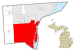 | |
| Charter townships | ||
| Civil township | ||
| Unincorporated communities |
| |
| Footnotes | ‡This populated place also has portions in an adjacent county or counties | |
Municipalities and communities of Wayne County, Michigan, United States | ||
|---|---|---|
County seat: Detroit | ||
| Cities |
|  |
| Charter townships | ||
| Civil townships | ||
| Unincorporated communities |
| |
| Footnotes | ‡This populated place also has portions in an adjacent county or counties | |
| ||
Metro Detroit | ||
|---|---|---|
| Topics |
|  |
| Detroit |
| |
| Municipalities over 80,000 | ||
| Municipalities 40,000 to 80,000 | ||
| Cultural enclaves |
| |
| Satellite cities | ||
| Counties in MSA | ||
| Counties in CSA | ||
| ||
Authority control | |
|---|---|
| General | |
| National libraries | |
Другой контент может иметь иную лицензию. Перед использованием материалов сайта WikiSort.org внимательно изучите правила лицензирования конкретных элементов наполнения сайта.
WikiSort.org - проект по пересортировке и дополнению контента Википедии