world.wikisort.org - United_Kingdom
Tyne and Wear (/ˌtaɪn ... ˈwɪər/) is a metropolitan county in North East England, situated around the mouths of the rivers Tyne and Wear. It was created in 1974, by the Local Government Act 1972, along with five metropolitan boroughs of Gateshead, Newcastle upon Tyne, Sunderland, North Tyneside and South Tyneside. It is bordered by Northumberland to the north and Durham to the south; the county boundary was formerly split between these counties with the border as the River Tyne.
Tyne and Wear | |
|---|---|
Metropolitan and Ceremonial county | |
 | |
| Sovereign state | United Kingdom |
| Constituent country | England |
| Region | North East |
| Established | 1974 (Local Government Act 1972) Created from the five county boroughs within Northumberland (North of Tyne) and County Durham (South of Tyne) |
| Time zone | UTC±00:00 (Greenwich Mean Time) |
| • Summer (DST) | UTC+01:00 (British Summer Time) |
| Police | Northumbria Police |
| Ceremonial county | |
| Lord Lieutenant | Lucy Winskell |
| High Sheriff | Mrs Sarah Stewart[1] (2020–21) |
| Area | 538 km2 (208 sq mi) |
| • Ranked | 44th of 48 |
| Population (mid-2019 est.) | 1,136,371 |
| • Ranked | 16th of 48 |
| Density | 2,105/km2 (5,450/sq mi) |
| Ethnicity | 2011:[2] 91.49% White British 4.10% Asian 1.98% Other White 0.97% Mixed 0.78% Black 0.67% Other |
| Metropolitan county | |
| Area | 538 km2 (208 sq mi) |
| ONS code | 2D |
| GSS code | E11000007 |
| ITL | UKC22/23 |
| Website | Lieutenancy website |
| Districts | |
 Districts of Tyne and Wear | |
| Districts | |
The former county council was based at Sandyford House. There is no longer county level local governance following the county council disbanding in 1986, by the Local Government Act 1985, with the metropolitan boroughs functioning separately. The county still exists as a metropolitan county and ceremonial purposes, as a geographic frame of reference.[3][4][5] There are two combined authorities covering parts of the county area, North of Tyne and North East.
History
In the late 600s and into the 700s Saint Bede lived as a monk at the monastery of St. Peter and of St. Paul writing histories of the Early Middle Ages including the Ecclesiastical History of the English People.[6]
Roughly 150 years ago, in the village of Marsden in South Shields, Souter Lighthouse was built, the first electric structure of this type.[7]
The Local Government Act 1888 constituted Newcastle upon Tyne, Gateshead and Sunderland as county boroughs (Newcastle had "county corporate" status as the "County and Town of Newcastle upon Tyne" since 1400). Tynemouth joined them in 1904. Between the county boroughs, various other settlements also formed part of the administrative counties of Durham and of Northumberland.
The need to reform local government on Tyneside was recognised by the government as early as 1935, when a Royal Commission to Investigate the Conditions of Local Government on Tyneside was appointed.[8] The three commissioners were to
examine the system of local government in the areas of local government north and south of the river Tyne from the sea to the boundary of the Rural District of Castle Ward and Hexham in the County of Northumberland and to the Western boundary of the County of Durham, to consider what changes, if any, should be made in the existing arrangements with a view to securing greater economy and efficiency, and to make recommendations.

The report of the Royal Commission, published in 1937,[9] recommended the establishment of a Regional Council for Northumberland and Tyneside (to be called the "Northumberland Regional Council") to administer services that needed to be exercised over a wide area, with a second tier of smaller units for other local-government purposes. The second-tier units would form by amalgamating the various existing boroughs and districts. The county boroughs in the area would lose their status. Within this area, a single municipality would be formed covering the four county boroughs of Newcastle, Gateshead, Tynemouth, South Shields and other urban districts and boroughs.[10]
A minority report proposed amalgamation of Newcastle, Gateshead, Wallsend, Jarrow, Felling, Gosforth, Hebburn and Newburn into a single "county borough of Newcastle-on-Tyneside". The 1937 proposals never came into operation: local authorities could not agree on a scheme and the legislation of the time did not allow central government to compel one.[11]
Tyneside (excluding Sunderland) was a Special Review Area under the Local Government Act 1958. The Local Government Commission for England came back with a recommendation to create a new county of Tyneside based on the review area, divided into four separate boroughs. This was not implemented. The Redcliffe-Maud Report proposed a Tyneside unitary authority, again excluding Sunderland, which would have set up a separate East Durham unitary authority.
The White Paper that led to the Local Government Act 1972 proposed as "area 2" a metropolitan county including Newcastle and Sunderland, extending as far south down the coast as Seaham and Easington, and bordering "area 4" (which would become Tees Valley). The Bill as presented in November 1971 pruned back the southern edge of the area, and gave it the name "Tyneside". The name "Tyneside" proved controversial on Wearside, and a government amendment changed the name to "Tyne and Wear" at the request of Sunderland County Borough Council.[12]
| post-1974 | pre-1974 | ||||
|---|---|---|---|---|---|
| Metropolitan county | Metropolitan borough | County boroughs | Non-county boroughs | Urban districts | Rural districts |
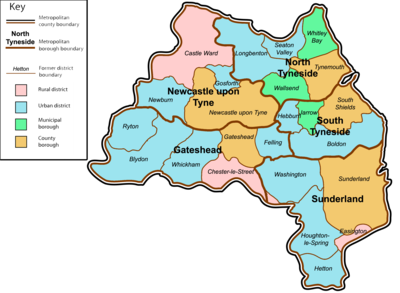 |
Gateshead | Gateshead | - | Blaydon • Felling • Ryton • Whickham | Chester-le-Street |
| Newcastle upon Tyne | Newcastle upon Tyne | - | Gosforth • Newburn | Castle Ward | |
| North Tyneside | Tynemouth | Wallsend • Whitley Bay | Longbenton • Seaton Valley | - | |
| South Tyneside | South Shields | Jarrow | Boldon • Hebburn | - | |
| Sunderland | Sunderland | - | Washington • Houghton-le-Spring • Hetton-le-Hole | Easington | |
Geography
Tyne and Wear either has or closely borders two official Met Office stations, neither located in one of the major urban centres. The locations for those are in marine Tynemouth where Tyne meets the North Sea east of Newcastle and inland Durham in County Durham around 20 kilometres (12 mi) south-west of Sunderland. There are some clear differences between the stations temperature and precipitation patterns even though both have a cool-summer and mild-winter oceanic climate.
| Climate data for Tynemouth 33m asl, 1981–2010 | |||||||||||||
|---|---|---|---|---|---|---|---|---|---|---|---|---|---|
| Month | Jan | Feb | Mar | Apr | May | Jun | Jul | Aug | Sep | Oct | Nov | Dec | Year |
| Average high °C (°F) | 7.2 (45.0) |
7.3 (45.1) |
9.0 (48.2) |
10.3 (50.5) |
12.7 (54.9) |
15.6 (60.1) |
18.1 (64.6) |
18.1 (64.6) |
16.1 (61.0) |
13.2 (55.8) |
9.7 (49.5) |
6.4 (43.5) |
12.1 (53.8) |
| Average low °C (°F) | 2.2 (36.0) |
2.2 (36.0) |
3.3 (37.9) |
4.8 (40.6) |
7.2 (45.0) |
10.0 (50.0) |
12.3 (54.1) |
12.3 (54.1) |
10.4 (50.7) |
7.7 (45.9) |
4.9 (40.8) |
2.5 (36.5) |
6.7 (44.1) |
| Average precipitation mm (inches) | 45.5 (1.79) |
37.8 (1.49) |
43.9 (1.73) |
45.4 (1.79) |
43.2 (1.70) |
51.9 (2.04) |
47.6 (1.87) |
59.6 (2.35) |
53.0 (2.09) |
53.6 (2.11) |
62.8 (2.47) |
53.9 (2.12) |
597.2 (23.51) |
| Mean monthly sunshine hours | 61.1 | 81.6 | 117.7 | 149.9 | 191.7 | 183.0 | 185.7 | 174.9 | 174.1 | 106.2 | 70.4 | 51.9 | 1,515 |
| Source: Met Office[13] | |||||||||||||
| Month | Jan | Feb | Mar | Apr | May | Jun | Jul | Aug | Sep | Oct | Nov | Dec | Year |
|---|---|---|---|---|---|---|---|---|---|---|---|---|---|
| Record high °C (°F) | 16.7 (62.1) |
17.4 (63.3) |
21.7 (71.1) |
24.1 (75.4) |
27.8 (82.0) |
30.6 (87.1) |
36.9 (98.4) |
32.5 (90.5) |
30.0 (86.0) |
25.0 (77.0) |
19.4 (66.9) |
15.9 (60.6) |
36.9 (98.4) |
| Average high °C (°F) | 6.9 (44.4) |
7.8 (46.0) |
9.9 (49.8) |
12.5 (54.5) |
15.4 (59.7) |
18.0 (64.4) |
20.2 (68.4) |
19.9 (67.8) |
17.4 (63.3) |
13.5 (56.3) |
9.7 (49.5) |
7.1 (44.8) |
13.2 (55.8) |
| Daily mean °C (°F) | 4.1 (39.4) |
4.6 (40.3) |
6.2 (43.2) |
8.3 (46.9) |
10.9 (51.6) |
13.6 (56.5) |
15.8 (60.4) |
15.6 (60.1) |
13.3 (55.9) |
10.0 (50.0) |
6.6 (43.9) |
4.2 (39.6) |
9.5 (49.1) |
| Average low °C (°F) | 1.3 (34.3) |
1.4 (34.5) |
2.5 (36.5) |
4.1 (39.4) |
6.5 (43.7) |
9.3 (48.7) |
11.3 (52.3) |
11.3 (52.3) |
9.2 (48.6) |
6.5 (43.7) |
3.6 (38.5) |
1.4 (34.5) |
5.7 (42.3) |
| Record low °C (°F) | −17.2 (1.0) |
−18.3 (−0.9) |
−15.0 (5.0) |
−11.1 (12.0) |
−4.4 (24.1) |
−1.1 (30.0) |
1.1 (34.0) |
0.6 (33.1) |
−1.1 (30.0) |
−5.5 (22.1) |
−8.8 (16.2) |
−16.6 (2.1) |
−18.3 (−0.9) |
| Average precipitation mm (inches) | 51.8 (2.04) |
44.6 (1.76) |
41.1 (1.62) |
51.2 (2.02) |
44.4 (1.75) |
61.0 (2.40) |
60.9 (2.40) |
66.5 (2.62) |
56.9 (2.24) |
63.4 (2.50) |
73.0 (2.87) |
61.0 (2.40) |
675.7 (26.60) |
| Average precipitation days (≥ 1.0 mm) | 11.8 | 9.9 | 8.6 | 9.1 | 8.6 | 9.9 | 10.7 | 10.3 | 9.4 | 11.8 | 12.0 | 12.0 | 124.1 |
| Mean monthly sunshine hours | 60.9 | 84.4 | 121.7 | 160.8 | 187.1 | 167.1 | 174.3 | 167.3 | 135.3 | 98.9 | 64.6 | 57.6 | 1,480 |
| Source 1: Met Office[14][15][16] | |||||||||||||
| Source 2: Durham Weather UK[17] | |||||||||||||
Green belt
Tyne and Wear contains green belt interspersed throughout the county, mainly on the fringes of the Tyneside/Wearside conurbation. There is also an inter-urban line of belt helping to keep the districts of South Tyneside, Gateshead, and Sunderland separated. It was first drawn up from the 1950s. All the county's districts contain some portion of belt.
Governance
Although Tyne and Wear County Council was abolished in 1986, several joint bodies exist to run certain services on a county-wide basis. Most notable is the Tyne and Wear Passenger Transport Authority, which co-ordinates transport policy. Through its passenger transport executive, known as Nexus, it owns and operates the Tyne and Wear Metro light rail system, and the Shields ferry service and the Tyne Tunnel, linking communities on either side of the River Tyne. Also through Nexus, the authority subsidises socially necessary transport services (including taxis) and operates a concessionary fares scheme for the elderly and disabled. Nexus has been an executive body of the North East Joint Transport Committee since November 2018.
Other joint bodies include the Tyne and Wear Fire and Rescue Service and Tyne & Wear Archives & Museums, which was created from the merger of the Tyne and Wear Archives Service and Tyne and Wear Museums. These joint bodies are administered by representatives of all five of the constituent councils. In addition the Northumbria Police force covers Northumberland and Tyne and Wear.
There have been occasional calls for Tyne and Wear to be abolished and the traditional border between Northumberland and County Durham to be restored.[18][19]
Tyne and Wear is divided into 12 Parliamentary constituencies. Historically, the area has been a Labour stronghold; South Shields is the only Parliamentary constituency that has never returned a Conservative Member of Parliament (MP) to the House of Commons since the Reform Act of 1832.
| Labour | Liberal Democrats | Conservative | Brexit | Others | Green | Turnout |
|---|---|---|---|---|---|---|
| 247,317 |
36,417 |
160,155 |
47,142 |
10,504 |
16,010 |
517,545 |
| Labour | Liberal Democrats | Conservative | BNP | UKIP | Others | Green | |
|---|---|---|---|---|---|---|---|
| 12 | 0 | 0 | 0 | 0 | 0 | 0 |
At the level of local government, all of the region's five unitary authorities were controlled by Labour in 2019.
Newcastle and Sunderland are known for declaring their election results early on election night.[20] Therefore, they frequently give the first indication of nationwide trends. An example of this was at the 2016 European Union referendum. Newcastle was the first large city to declare, and 50.6% of voters voted to Remain; this proportion was far lower than predicted by experts. Sunderland declared soon after and gave a 62% vote to Leave, much higher than expected. These two results were seen as an early sign that the United Kingdom had voted to Leave.
Settlements

Italics indicate the district centre. For a complete list of all villages, towns and cities see the list of places in Tyne and Wear.
Places of interest
- Gateshead
- Angel of the North
- Beamish Museum, which straddles the Gateshead/County Durham boundary
- BALTIC Centre for Contemporary Art
- Dunston Staiths
- Gateshead International Stadium
- Gateshead Millennium Bridge
- Gibside
- MetroCentre
- Saltwell Park
- Shipley Art Gallery
- Tanfield Railway, Sunniside (crosses boundary into County Durham)
- The Sage Gateshead
- Tyne Bridge (Shared with Newcastle upon Tyne)
- Newcastle upon Tyne
- Discovery Museum (previously Museum of Science & Engineering)
- Hadrian's Wall
- Hancock Museum
- Jesmond Dene public park
- Newcastle Castle Keep
- St James' Park
- Leazes Park
- Centre for Life
- Town Moor
- Tyneside cinema
- Chinatown, Newcastle
- Quayside
- Utilita Arena Newcastle
- Newcastle Cathedral
- Laing Art Gallery
- Theatre Royal
- Northumberland Street
- Grey Street
- Grey's Monument
- The Biscuit Factory
- Tyne Bridge (Shared with Gateshead)
- North Tyneside
- Segedunum Roman Fort & Museum, Wallsend
- St Mary's Island bird reserve
- Tynemouth Castle
- South Tyneside
- Arbeia Roman Fort & Museum, South Shields
- Marsden Rock bird reserve
- Souter Point Lighthouse
- Bede's World, Jarrow
- Sunderland
- The Museum and Winter Gardens
- Mowbray Park
- Seaburn Beach and Roker Beach
- Barnes Park
- The National Glass
- Hylton Castle
- Penshaw Monument
- St. Peter's Church
- Sunderland Minster
- Stadium of Light
- The Empire Theatre
- Northern Gallery for Contemporary Art
Businesses

Offshore Group Newcastle make oil platforms. Sage Group, who produce accounting software, are based at Hazlerigg at the northern end of the Newcastle bypass. Northern Rock, which became a bank in 1997 and was taken over by Virgin Money in November 2011, and the Newcastle Building Society are based in Gosforth. The Gosforth-based bakery Greggs now has over 1,500 shops. The Balliol Business Park in Longbenton contains Procter & Gamble research and global business centres and a tax credits call centre for HMRC, and is the former home of Findus UK. The Government National Insurance Contributions Office in Longbenton, demolished and replaced in 2000, had a 1 mile (1.6 km) long corridor.[citation needed]
Be-Ro and the Go-Ahead Group bus company are in central Newcastle. Nestlé use the former Rowntrees chocolate factory on the east of the A1. BAE Systems Land & Armaments in Scotswood, formerly Vickers-Armstrongs, is the main producer of British Army tanks such as the Challenger 2. A Rolls Royce apprentice training site is next door.[21] Siemens Energy Service Fossil make steam turbines at the CA Parsons Works in South Heaton. Sir Charles Parsons invented the steam turbine in 1884, and developed an important local company. Domestos, a product whose main ingredient is sodium hypochlorite, was originated in Newcastle in 1929 by William Handley, and was distributed from the area for many years.
Clarke Chapman is next to the A167 in Gateshead. The MetroCentre, the largest shopping centre in Europe, is in Dunston. Scottish & Newcastle was the largest UK-owned brewery until it was bought by Heineken and Carlsberg in April 2008, and produced Newcastle Brown Ale at the Newcastle Federation Brewery in Dunston until production moved to Tadcaster in September 2010. At Team Valley are De La Rue, with their largest banknote printing facility, and Myson Radiators, the second largest in the UK market. Petards make surveillance equipment including ANPR cameras, and its Joyce-Loebl division makes electronic warfare systems and countermeasure dispensing systems such as the AN/ALE-47. Sevcon, an international company formed from a part of Smith Electric, is a world leader in electric vehicle controls. AEI Cables and Komatsu UK construction equipment at Birtley.
J. Barbour & Sons make outdoor clothing in Simonside, Jarrow. SAFT Batteries make primary lithium batteries on the Tyne in South Shields. Bellway plc houses is in Seaton Burn in North Tyneside. Cobalt Business Park, the largest office park in the UK, is at Wallsend, on the former site of Atmel, and is the home of North Tyneside Council. Swan Hunter until 2006 made ships in Wallsend, and still designs ships. Soil Machine Dynamics in Wallsend on the Tyne makes Remotely operated underwater vehicles, and its Ultra Trencher 1 is the world's largest submersible robot.[citation needed]
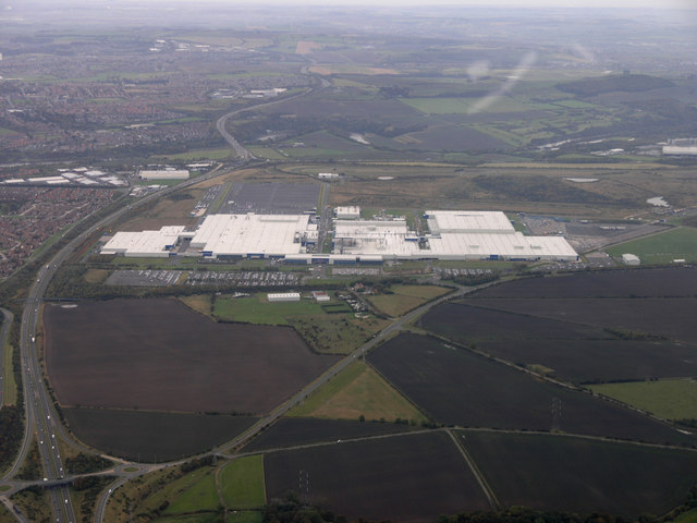
The car dealership Evans Halshaw is in Sunderland. The car factory owned by Nissan Motor Manufacturing UK between North Hylton and Washington is the largest in the UK. Grundfos, the world's leading pump manufacturer, builds pumps in Sunderland. Calsonic Kansei UK, formerly Magna, make automotive instrument panels and car trim at the Pennywell Industrial Estate. Gestamp UK make automotive components. Smith Electric Vehicles originated in Washington. The LG Electronics microwave oven factory opened in 1989, closed in May 2004, and later became the site of the Tanfield Group. Goodyear Dunlop had their only UK car tyre factory next to the Tanfield site until its 2006 closure. BAE Systems Global Combat Systems moved to a new £75 million factory at the former Goodyear site in 2011, where they make large calibre ammunition for tanks and artillery.
The government's child benefit office is in Washington. Liebherr build cranes next to the Wear at Deptford. The outdoor clothing company Berghaus is in Castletown. Vaux Breweries, who owned Swallow Hotels, closed in 1999. ScS Sofas are on Borough Road. There are many call centres in Sunderland, notably EDF Energy at the Doxford International Business Park, which is also the home of the headquarters of the large international transport company Arriva and Nike UK. Rolls Royce planned to move their production of fan and turbine discs to BAE Systems' new site in 2016.[needs update]
See also
- List of Lord Lieutenants of Tyne and Wear
- List of High Sheriffs of Tyne and Wear
- Tyne–Wear derby
References
- "No. 62943". The London Gazette. 13 March 2020. p. 5161.
- "2011 census: Ethnic group (detailed)". Office for National Statistics. Archived from the original on 20 May 2018. Retrieved 19 May 2018.
- Office for National Statistics Archived 23 December 2003 at the UK Government Web Archive - Gazetteer of the old and new geographies of the United Kingdom, p48. URL accessed 12 March 2007.
- Metropolitan Counties and Districts Archived 6 June 2002 at the UK Government Web Archive, Beginners' Guide to UK Geography, Office for National Statistics, 17 September 2004. URL accessed 12 March 2007.
- North East England Counties Archived 10 April 2007 at the Wayback Machine, The Boundary Commission for England. URL accessed 12 March 2007.
- "The Venerable Bede - England's first great historian". British Heritage. 29 October 2020. Retrieved 8 March 2021.
- "Five of England's less-visited counties for days out and short breaks". Guardian. 6 March 2021. Retrieved 8 March 2021.
- London Gazette, 10 May 1935
- Local Government in the Tyneside Area (Cmd.5402)
- Government of Tyneside : a Regional Council. The Times. 19 March 1937.
- Local Government on Tyneside. Sir K. Wood and Report of Commission. The Times. 22 September 1937.
- Hansard, 6 July 1972, column 909
- "Tynemouth climate information". Met Office. Archived from the original on 28 April 2016. Retrieved 13 August 2015.
- "Durham (Durham) UK climate averages". Met Office. 1991–2020. Retrieved 1 January 2022.
- "Exceptional warmth, December 2015". Met Office. 27 January 2016. Retrieved 19 October 2017.
- Kendon, Mike; McCarthy, Mark; Jevrejeva, Svetlana; Legg, Tim (2015). "State of the UK Climate 2015" (PDF). Met Office. Retrieved 29 March 2018.
- "North East England Climate : Durham Weather". Durham Weather UK. Retrieved 15 July 2020.
- "Call to return the county to its historic status". Northumberland Gazette. 19 March 2016.
- Henderson, Tony (3 January 2019). "Are there signs that our traditional county boundaries are set to return?". Evening Chronicle.
- Rodger, James (8 June 2017). "Why Sunderland and Newcastle always declare election results first". birminghammail.
- "RRTEC". Rrnetc.co.uk. Archived from the original on 26 April 2012. Retrieved 12 June 2012.
External links
- Images of Tyne and Wear at the English Heritage Archive
- Tyne and Wear at Curlie

На других языках
- [en] Tyne and Wear
[es] Tyne y Wear
Tyne y Wear (en inglés: Tyne and Wear, pronunciado /ˌtaɪn ənd ˈwɪə/) es uno de los cuarenta y siete condados de Inglaterra, Reino Unido, con capital en Newcastle. Ubicado en la región Nordeste limita al oeste y norte con Northumberland, al este con el mar del Norte y al sur con Durham.[1][2] Comprende la zona de los estuarios de los ríos Tyne y Wear.[ru] Тайн-энд-Уир
Тайн-энд-Уир (англ. Tyne and Wear, [ˌtaɪn ən ˈwɪər]) — церемониальное метрополитенское графство на севере Англии. Входит в состав региона Северо-Восточная Англия. Крупнейший город — Ньюкасл. Население 1,086 млн человек (12-е место среди церемониальных графств; данные 2004 г.).Другой контент может иметь иную лицензию. Перед использованием материалов сайта WikiSort.org внимательно изучите правила лицензирования конкретных элементов наполнения сайта.
WikiSort.org - проект по пересортировке и дополнению контента Википедии