world.wikisort.org - United_Kingdom
Tadcaster is a market town and civil parish in the Selby district of North Yorkshire, England, 3 miles (5 km) east of the Great North Road, 12 miles (19 km) north-east of Leeds, and 10 miles (16 km) south-west of York. Its historical importance from Roman times onward was largely as the lowest road crossing-point on the River Wharfe until the construction of the A64 Tadcaster by-pass some 660 yards (600 m) to the south, in 1978. There are two rail crossings downstream of the town before the Wharfe joins the River Ouse near Cawood.
This article has multiple issues. Please help improve it or discuss these issues on the talk page. (Learn how and when to remove these template messages)
|
| Tadcaster | |
|---|---|
 Tadcaster High Street | |
 Tadcaster Location within North Yorkshire | |
| Population | 6,003 (2011 census)[1] |
| OS grid reference | SE4843 |
| • London | 170 mi (270 km) SSE |
| Civil parish |
|
| District |
|
| Shire county | |
| Region | |
| Country | England |
| Sovereign state | United Kingdom |
| Post town | TADCASTER |
| Postcode district | LS24 |
| Dialling code | 01937 |
| Police | North Yorkshire |
| Fire | North Yorkshire |
| Ambulance | Yorkshire |
| UK Parliament |
|
Tadcaster is twinned with Saint-Chély-d'Apcher in France.
The town was part of the West Riding of Yorkshire until 1974, but is now part of North Yorkshire.[3] Thanks to its position on the banks of the River Wharfe parts of the town adjacent to the bridge are prone to flooding.[4]
History
Roman

The Romans built a settlement and named it Calcaria from the Latin word for lime, reflecting the importance of the area's limestone geology as a natural resource for quarrying, an industry which continues and has contributed to many notable buildings including York Minster. Calcaria was an important staging post that grew at the crossing of the River Wharfe on the road to Eboracum (York).[5]
Anglo-Saxon and medieval
The suffix of the Anglo-Saxon name Tadcaster is derived from the borrowed Latin word castra meaning 'fort', although the Angles and Saxons used the term for any walled Roman settlement. Tadcaster is first mentioned in the Anglo-Saxon Chronicle, where it appears as Táda, referring to the place where King Harald assembled his army and fleet before entering York and proceeding onwards to the Battle of Stamford Bridge in 1066. The place-name probably means 'Tata's fort'[6] after an unknown Anglo-Saxon landowner.
The town is mentioned in the 1086 Domesday Book as "Tatecastre". The record reads:
Two Manors. In Tatecastre, Dunstan and Turchil had eight carucates of land for geld, where four ploughs may be. Now, William de Parci has three ploughs and 19 villanes and 11 bordars having four ploughs, and two mills of ten shillings (annual value). Sixteen acres of meadow are there. The whole manors, five quaranteens in length, and five in breadth. In King Edward's time they were worth forty shillings; now one hundred shillings.[citation needed]
In the 11th century William de Percy established a motte-and-bailey fortress re-using Roman stone. The earthwork remains of this castle, including the motte (known as Castle Hill) can still be seen adjacent to the parish church and bridge. The castle was abandoned in the early-12th century and was briefly re-fortified with cannon emplacements during the Civil War. The street plan south of the site reflects the shape of the former bailey.
The original river-crossing was probably a ford near the current bridge, followed by a wooden bridge [citation needed]. Around 1240, the first stone bridge was constructed, possibly from stone reclaimed from the castle.[citation needed] The current bridge was constructed on the foundations of the original c. 1700, although it has been substantially modified at least twice since. Historically, the Wharfe marked the boundary between the West Riding and the Ainsty of York.
Civil War
During the English Civil War, on the morning of Tuesday 7 December 1642 the Battle of Tadcaster, a skirmish[clarification needed], between Sir Thomas Fairfax's Parliamentarian forces and Sir Thomas Glemham's Royalist army took place on and around Tadcaster Bridge.
Market
A market has been held since 1270, when Henry de Percy obtained a royal charter from King Henry III to hold "a market and fair at his manor of Tadcaster" each Tuesday. The ancient market place is at the junction of Kirkgate and Bridge Street. A stone base, believed to have been part of the original market cross, stood on Westgate where the Tadcaster War Memorial now stands [citation needed] The present-day market is held on Thursdays in the car park of Tadcaster Social Club on St Josephs Street.
Governance
Tadcaster Town Council | |
|---|---|
| Type | |
| Type | Town Council |
| Leadership | |
Mayor | Steve Cobb |
Town clerk | Jane Crowther |
| Structure | |
| Seats | 12 Councillors [7] |
Independent | 6 / 12 |
Labour | 3 / 13 |
Conservative | 2 / 12 |
Vacant | 1 / 12 |
| Elections | |
Voting system | Plurality-at-large |
Last election | 7 May 2019 |
Next election | 2 May 2023 |
| Meeting place | |
| The Ark, Tadcaster | |
| Website | |
| tadcastertowncouncil | |
For local government purposes, the River Wharfe divides the town into eastern and western electoral wards. The combined population of Tadcaster East and Tadcaster West in 2004 was 7,280, 3,800 in Tadcaster East and 3,480 in Tadcaster West (source: Office for National Statistics). The local authority is Selby District Council.
Tadcaster gave its name to a much larger rural district council, Tadcaster Rural District and other administrative areas. This may lead to confusion when comparing the size and extent of the current town with information for earlier periods. For example, the population in 1911 of the Tadcaster sub-district was 6831 compared with that of the Tadcaster Registration District, 32052 (source: A Vision of Britain through time).
Tadcaster also elects a mayor on an annual basis.[8]
Economy

Tadcaster has a long association with the brewing industry because of the quality and accessibility of the local water, which is rich in lime sulphate after filtering through Permian limestone. In the right conditions freshwater springs, known locally as popple-wells, still bubble up near St Mary's church in the town. [citation needed] Tax registers from 1341 record the presence of two breweries or brewhouses in the town, one paying 8d in tax and the other 4d. Today Tadcaster is second in importance only to Burton-upon-Trent as an English brewing centre.[citation needed]

Currently there are three breweries in the town: The Tower Brewery (Coors, formerly Bass), John Smith's and Samuel Smith's Old Brewery, which is the oldest brewery in Yorkshire and only remaining independent brewery in Tadcaster. A fourth brewery stood by the river on the site of the present central car park.[citation needed]
Despite these large commercial enterprises, Tadcaster exhibits many signs of urban decline, with a large number of empty and derelict properties in the town centre. In part this can be attributed to disputes between the owner of the Samuel Smith's brewery, Humphrey Smith, who is a major landowner in the town, and Selby District Council.[9] There are no major tourist attractions in the town, which has one supermarket and no bank. The closure of the railway station (1964), the reduction of the market and the construction of the A64 Tadcaster bypass (1978), whilst substantially reducing traffic using the Tadcaster Bridge, have all contributed to the decline of footfall and therefore of retailing in the town.
Culture and community
Local newspapers covering Tadcaster include The Press and the Wetherby News. The major regional newspaper in the area is The Yorkshire Post. The local BBC radio station is Radio York, and commercial stations include Greatest Hits Radio York and North Yorkshire and Capital Yorkshire.
A leisure centre on Station Road provides for a variety of sport activities, and is the base for private sports clubs and a physiotherapy clinic.
Tadcaster's community swimming pool, which includes a fitness suite, opened in December 1994; run as a charity. At the end of 2007 the pool underwent repairs costing £130,000, reopening in 2008; some fundraising was through a celebrity football match, one side of which was formed from cast in television soap Emmerdale.[citation needed]
The route of The White Rose Way, a long-distance walk from Leeds to Scarborough, passes through the town.
Jan Dalibor, co-creator of the children's TV puppets Pinky and Perky, worked as a quarryman at Tadcaster after his arrival as a refugee from Czechoslovakia.[10]
Tadcaster is twinned with the town of Saint-Chély-d'Apcher in the Lozère department of southern France.[citation needed]
Landmarks
Breweries
The colossal John Smith's Brewery (1883, with later additions), a notable example of Victorian industrial architecture, stands on the site of John Smith's earlier brewery at the southern end of the High Street. The tall stone chimney and ornate wrought-iron atrium are prominent features and are listed (protected) structures.
Adjacent to these, across the narrow New Street, are the more modest Georgian headquarters of Samuel Smith's Brewery, with a handsome frontage on the High Street.
The Ark

The oldest building in active use in the town [citation needed], other than the parish church, is the half-timbered building on Kirkgate known as 'The Ark', built in the late 15th century, although it has been enlarged and altered many times since. Two carved heads on its front are thought to represent Noah and his wife [citation needed], hence the name. The Ark has been a meeting place, a post office, an inn, a butcher's shop, a private house and a museum; it is currently the Town Council offices.[citation needed] In the 17th century it was known as Morley Hall, and was licensed for Presbyterian meetings. Some of the so-called Pilgrim Fathers are reputed to have planned their voyage to America in the building; an exact replica exists in Ohio, US.[citation needed]
Viaduct
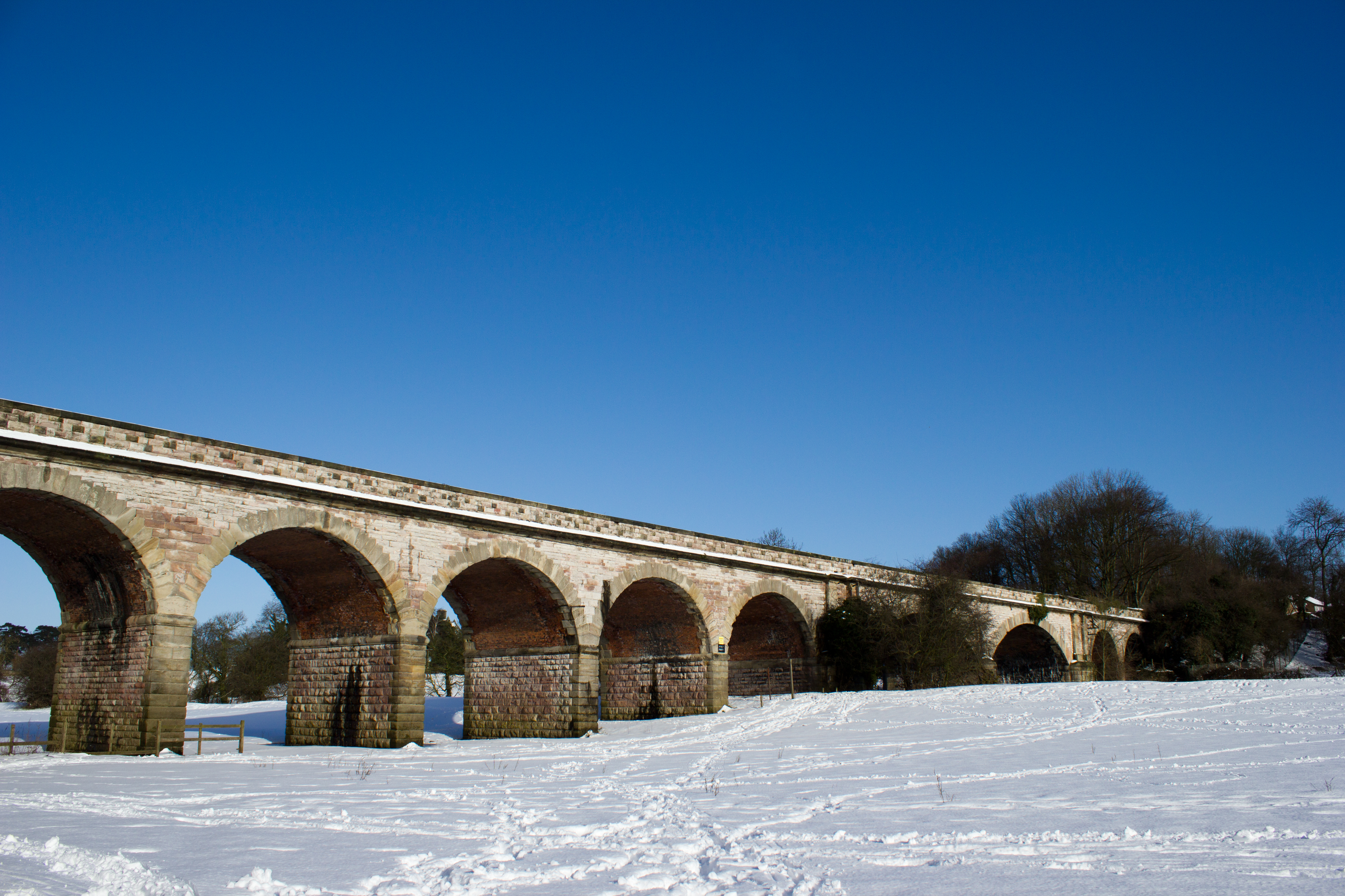
The eleven-arch Tadcaster railway viaduct is 1⁄4-mile (400 m) above the Wharfe bridge; it was built as part of a projected York and North Midland Railway (Leeds Extension) line from Leeds to York. Construction of the line was authorised in 1846, and much of the northern section including the viaduct had been completed when the collapse of railway investment in 1849 led to its abandonment. Between 1883 and 1959 the viaduct carried a short branchline servicing a corn mill on the east side of the River Wharfe (Mill Lane area). The viaduct is a Grade II listed building owned by Tadcaster Town Council.[11]
Bridge

The current bridge dates back to around 1700.[12] It is the main transport route connecting the town centre, which is divided by the river, and one of the town's two road crossings, the other being the A64 bypass bridge. The bridge partially collapsed on 29 December 2015, following flooding.[13][14] The collapse fractured a gas main and prompted the evacuation of hundreds of residents and divided the town in two.[15] In early 2016, Historic England carried out an assessment of the significance of the Grade-II listed bridge to inform its restoration.[16] The bridge was then repaired and widened, and re-opened to traffic on 3 February 2017. The area around the bridge, including the north end of the High Street, the bus station and the Medical Centre were flooded once again in February 2022.[4]
Tadcaster Mere
To the south east of the town centre, towards the village of Oxton, lies Tadcaster Mere. Designated a Site of Special Scientific Interest (SSSI) in 1987, the mere is at the centre of a former lake basin that extended over an area of about 740 acres (3 km2). It was formed during the most recent or Devensian ice age, which ended 10,000 years ago, when Tadcaster was at the southernmost limit of glaciation, by the long, low embankment of debris known as the Escrick Moraine, which is composed of debris left behind by the Vale of York Glacier. The mere is a site of current palaeontological interest, as it is believed to be the site of the earliest discovery of the plesiosaur; while unproven, the skeletal fragments found in Tadcaster match the age of those found elsewhere.[17]
Scientific analysis of the mere, in particular sedimentary pollen studies, provides insight into the geological history and makeup of the local environment and allows accurate dating of events before, during and after the Devensian ice age.[according to whom?]
Religion

St Mary's Church, on the banks of the Wharfe, was founded around 1150[citation needed]. A wooden building existed before the current church [citation needed]. It was destroyed by the Scots in one of many incursions after the Battle of Bannockburn in 1318.[citation needed] St Mary's was rebuilt between about 1380 and 1480[citation needed]. Due to repeated flooding a it was dismantled and reconstructed between 1875 and 1877 on foundations raised by 5 feet (1.5 m), though the tower was left untouched[citation needed]. £8,426 4s 6½d was raised by public subscription for this renovation. In 1897 a new north aisle was added.[18]
Transport


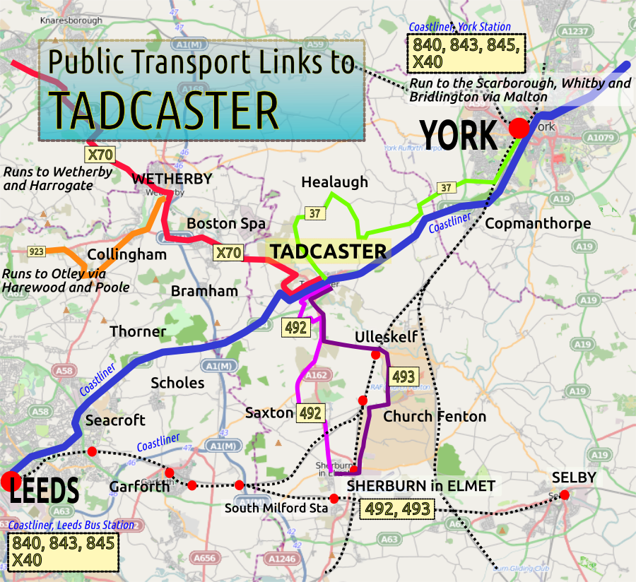
Tadcaster is served by local bus services operating from Leeds City bus station. The town is a stop on the Yorkshire Coastliner service, which accesses the Yorkshire Coast. Buses also run to Wetherby and Harrogate and to Sherburn-in-Elmet.[19] On Mondays a bus service runs to and from Selby.[20]
Tadcaster railway station on the Church Fenton to Harrogate line closed to passengers in January 1964.[21] The nearest railway stations are Ulleskelf, Church Fenton and York railway station which has a wider range of services and is connected to Tadcaster by the Yorkshire Coastliner bus service.[22]
Tadcaster lies on the A64, A659 and A162 main roads, and is about 3 miles east of the A1(M) (Junction 44).
Education

Tadcaster has three primary schools (serving ages 5–11) and a secondary school (ages 11–18). In the summer 1999 league tables, Tadcaster Grammar School students obtained the best A Level results in the country for a state comprehensive school.[citation needed] The adult education centre is located in the Grammar School.[citation needed]
Sport
Tadcaster has two main football teams, Tadcaster Albion and Tadcaster Magnets, Tadcaster Rugby Football Club, Tadcaster Harriers running club and Cyclesense Cycling Club. Tadcaster Tornadoes Basketball Team play in the Leeds Basketball League (Men's). Tadcaster has a swimming team for young people up to the age of 18. (Tadcaster Swim Squad).[23]
References
- UK Census (2011). "Local Area Report – Tadcaster Parish (1170217437)". Nomis. Office for National Statistics. Retrieved 21 March 2018.
- "Home - Tadcaster Town Council". Tadcastertowncoucil.gov.uk. Retrieved 14 September 2020.
- "History of Tadcaster, in Selby and West Riding | Map and description". Visionofbritain.org.uk. Retrieved 25 November 2020.
- "'We're devastated': Yorkshire town hit by floods for third time in decade". The Guardian. 21 February 2022. Retrieved 21 March 2022.
- "Genuki: TADCASTER: Geographical and Historical information from the year 1834., Yorkshire (West Riding)". Genuki.org.uk. Retrieved 6 November 2018.
- Ekwall, Eilert (1960). The concise Oxford dictionary of English place-names (4 ed.). Oxford: Oxford University Press. p. 458. ISBN 0-19-869103-3.
- "Town Councillors". Archived from the original on 27 November 2015. Retrieved 4 April 2021.
- "Town Mayor - Tadcaster Town Council". Tadcastertowncouncil.gov.uk. Retrieved 6 March 2019.
- "Supreme Court ends brewery's council challenge hopes". Selebian News. Retrieved 21 March 2022.
- "Vlasta Dalibor, puppeteer - obituary". The Daily Telegraph. 29 February 2016. Retrieved 12 April 2022.
- Historic England. "DISUSED RAILWAY VIADUCT OVER RIVER WHARFE (TO NORTH OF TOWN) (1167141)". National Heritage List for England. Retrieved 10 July 2014.
- "Historic Tadcaster". Tadcaster Town Council. Retrieved 29 December 2015.
- "Moment Tadcaster bridge collapsed". BBC News. 29 December 2015. Retrieved 9 April 2018.
- "Picture special: Residents vow to get on with it after Biblical flooding leaves Tadcaster like a war zone". Yorkshire Post. 30 December 2015. Archived from the original on 9 March 2016. Retrieved 14 September 2020.
- Quinn, Ben (29 December 2015). "Soldiers evacuate homes after Tadcaster bridge collapses". The Guardian. Retrieved 9 April 2018.
- Jecock, M.; Jessop, L. (2016). "Tadcaster Bridge, Tadcaster, North Yorkshire: Assessment of Significance. Historic England Research Report 27/2016". research.historicengland.org.uk. Retrieved 15 May 2020.
- "Palaecology, archaeology and nature: Assemblage issue 3". Archived from the original on 19 July 2011. Retrieved 11 January 2010.
- Anker, Malcolm (1987). Guided Tour and Short History of Saint Mary's Church Tadcaster (Reprinted with corrections 2016 ed.). Available from the church.
- "(Large map)". Tadwalks.org.uk. Retrieved 2 July 2022.
- "495: Buses from Tadcaster to Selby".
- "Disused Stations:Tadcaster Station". Disused-stations.org.uk. Retrieved 8 November 2018.
- "743 Leeds - York (& Malton) ~ Transdev". Archived from the original on 16 January 2014. Retrieved 15 January 2014.
- "Tadcaster Swim Squad – Every race is an opportunity to measure yourself against your own potential". Tadcasterswimsquad.org. Retrieved 9 April 2018.
External links
- Town Council and general Tadcaster site
- A Vision of Britain through Time: Tadcaster
- Tadcaster - community spirit after the floods
- The ancient parish of Tadcaster: historical and genealogical information at GENUKI. Considered as part of the Ainsty of York
- The ancient parish of Tadcaster: historical and genealogical information at GENUKI. Considered as part of the West Riding: the ancient parish was partly in the Ainsty and partly in the West Riding.
Authority control | |
|---|---|
| General | |
| National libraries | |
На других языках
[de] Tadcaster
Tadcaster ist eine Kleinstadt im District Selby der englischen Grafschaft North Yorkshire. Die Stadt hatte 2004 insgesamt 7280 Einwohner.- [en] Tadcaster
Другой контент может иметь иную лицензию. Перед использованием материалов сайта WikiSort.org внимательно изучите правила лицензирования конкретных элементов наполнения сайта.
WikiSort.org - проект по пересортировке и дополнению контента Википедии