world.wikisort.org - United_Kingdom
The London Borough of Ealing (/ˈiːlɪŋ/ (![]() listen)) is a London borough in West London. It comprises seven major towns: Acton (W3), Ealing (W5, W13, NW10), Greenford (UB6), Hanwell (W7), Northolt (UB5), Perivale (UB6) and Southall (UB1, UB2).[2][3] With a population of 367,100 inhabitants, it is the third most populous London borough.
listen)) is a London borough in West London. It comprises seven major towns: Acton (W3), Ealing (W5, W13, NW10), Greenford (UB6), Hanwell (W7), Northolt (UB5), Perivale (UB6) and Southall (UB1, UB2).[2][3] With a population of 367,100 inhabitants, it is the third most populous London borough.
London Borough of Ealing | |
|---|---|
Borough | |
 Coat of arms Council logo | |
| Motto: Progress with Unity | |
 Ealing shown within Greater London | |
| Sovereign state | United Kingdom |
| Constituent country | England |
| Region | London |
| Ceremonial county | Greater London |
| Created | 1 April 1965 |
| Admin HQ | Ealing Town Hall, Uxbridge Road, Ealing |
| Government | |
| • Type | London borough council |
| • Body | Ealing London Borough Council |
| • Leadership |
|
| • Mayor | Cllr Mohinder Midha |
| • London Assembly | Onkar Sahota AM for Ealing and Hillingdon |
| • MPs |
|
| Area | |
| • Total | 21.44 sq mi (55.53 km2) |
| • Rank | 259th (of 309) |
| Population (mid-2019 est.) | |
| • Total | 341,806 |
| • Rank | 23rd (of 309) |
| • Density | 16,000/sq mi (6,200/km2) |
| • Ethnicity[1] |
|
| Time zone | UTC (GMT) |
| • Summer (DST) | UTC+1 (BST) |
| Postcodes | |
| Area code | 020 |
| ONS code | 00AJ |
| GSS code | E09000009 |
| Police | Metropolitan Police |
| Website | https://www.ealing.gov.uk |
Ealing is the third largest London borough in population and eleventh largest in area, covering part of West London and a small part of Northwest London. It bridges Inner and Outer London.[4] Ealing's administrative centre is in Ealing Broadway. Ealing London Borough Council is the local authority. Ealing has long been known as the "Queen of the Suburbs" due to its many parks and tree-lined streets; the term was coined in 1902 by Ealing's borough surveyor, Charles Jones.[5] This is reflected by the tree emblem seen on the Ealing Council logo and Ealing's coat of arms.[6][7]
Location
The London Borough of Ealing borders the London Borough of Hillingdon to the west, the London Borough of Harrow and London Borough of Brent to the north, the London Borough of Hammersmith and Fulham to the east and the London Borough of Hounslow to the south.
The modern London borough was formed in 1965 under the London Government Act 1963.[8] At the same time, the act abolished several local councils, some of which had covered areas now covered by the newly created London borough of Ealing. These were: the Municipal Borough of Ealing (which included Ealing, Greenford, Hanwell, Perivale, Tyford Abbey and Northolt), the Municipal Borough of Southall and the Municipal Borough of Acton.
Ealing is also the primary setting for The Sarah Jane Adventures, being the location of Sarah Jane Smith's home.
Within the borough are two garden suburbs, Brentham Garden Suburb and Bedford Park.
330 hectares within the borough are designated as part of the Metropolitan Green Belt.
Districts
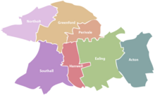
Ealing borough is made up of seven major towns:
- Acton (W3)
- Ealing (W5, W13, NW10)
- Greenford (UB6)
- Hanwell (W7)
- Northolt (UB5)
- Perivale (UB6)
- Southall (UB1, UB2).
Parliamentary constituencies in Ealing
The London Borough of Ealing is represented by three Members of Parliament (MPs), elected in the following constituencies:
- Ealing Central and Acton
- Ealing North
- Ealing Southall
London Fire Brigade
There are four fire stations within the London Borough of Ealing. Southall and Northolt have similar-sized station grounds and both house two pumping appliances. Southall attended[clarification needed] some 700 incidents more than their Northolt counterparts in 2006/07. Ealing, with two pumping appliances, and Acton, one pump and two fire investigation units, are the other two appliances in the area. The ward of Northfield had over forty malicious calls made from it, more than twice as many as any other ward within Ealing.[9]
Education
Ealing has a total of 91 state-run schools and nurseries. There are 13 high schools under the domain of the local education authority, 12 of which are either comprehensive, foundation or voluntary-aided, and one city academy.
A number of successful independent schools, including St Benedict's School (co-ed), the Barbara Speake Stage School (co-ed, ages 4–16), St Augustine's Priory (girls) and Notting Hill & Ealing High School (girls), are also located within the borough. The King Fahad Academy is an independent Saudi funded school within the borough.
The Japanese School in London is a Japanese international school in Acton.[10]
Demographics

The borough of Ealing is ethnically diverse. In 2011, 49% gave their ethnicity as white, 30% as Asian, 15% as Black and 4.5% as of mixed or multiple ethnicity, the remaining identifying as Arab or other ethnicity.[1] The main religions of the borough's population in 2011 were Christianity (44%), Islam (16%) Hinduism (9%) and Sikhism (8%); 15% stated they had no religion and a further 7% did not state any religion.[11]
| Year | Pop. | ±% |
|---|---|---|
| 1801 | 4,033 | — |
| 1811 | 4,578 | +13.5% |
| 1821 | 5,455 | +19.2% |
| 1831 | 6,510 | +19.3% |
| 1841 | 10,919 | +67.7% |
| 1851 | 11,434 | +4.7% |
| 1861 | 24,489 | +114.2% |
| 1871 | 37,544 | +53.3% |
| 1881 | 50,599 | +34.8% |
| 1891 | 67,976 | +34.3% |
| 1901 | 105,463 | +55.1% |
| 1911 | 163,628 | +55.2% |
| 1921 | 190,486 | +16.4% |
| 1931 | 221,801 | +16.4% |
| 1941 | 259,250 | +16.9% |
| 1951 | 303,029 | +16.9% |
| 1961 | 301,757 | −0.4% |
| 1971 | 300,577 | −0.4% |
| 1981 | 278,671 | −7.3% |
| 1991 | 281,743 | +1.1% |
| 2001 | 300,947 | +6.8% |
| 2011 | 338,449 | +12.5% |
| Note:[12] | ||
Ethnicity
| Ethnic Group | 1991[13] | 2001[14] | 2011[15] | |||
|---|---|---|---|---|---|---|
| Number | % | Number | % | Number | % | |
| White: Total | 186,377 | 67.7% | 176,741 | 58.8% | 165,818 | 48.78% |
| White: British | – | – | 135,139 | 44.9% | 103,035 | 30.4% |
| White: Irish | – | – | 14,285 | 4.7% | 10,428 | 3.0% |
| White: Gypsy or Irish Traveller | – | – | – | – | 300 | 0.08% |
| White: Other | – | – | 27,317 | 9% | 52,055 | 15.3% |
| Asian or Asian British: Total | 62,179 | 22.5% | 73,851 | 24.5% | 100,439 | 29.5% |
| Asian or Asian British: Indian | 44200 | 49,734 | 16.4% | 48,240 | 14.2% | |
| Asian or Asian British: Pakistani | 7440 | 11,271 | 3.7% | 14,711 | 4.3% | |
| Asian or Asian British: Bangladeshi | 763 | 1,077 | 0.3% | 1,786 | 0.5% | |
| Asian or Asian British: Chinese | 2460 | 3,596 | 1.1% | 4,132 | 1.2% | |
| Asian or Asian British: Other Asian | 7316 | 11,769 | 3.9% | 31,570 | 9.3% | |
| Black or Black British: Total | 19,472 | 7.1% | 26,456 | 8.7% | 36,860 | 10.7% |
| Black or Black British: African | 4335 | 11,075 | 3.6% | 17,299 | 5.1% | |
| Black or Black British: Caribbean | 12220 | 13,507 | 4.4% | 13,192 | 3.8% | |
| Black or Black British: Other Black | 2917 | 1,874 | 0.6% | 6,369 | 1.8% | |
| Mixed or British Mixed: Total | – | – | 10,880 | 3.6% | 15,066 | 4.2% |
| Mixed: White and Black Caribbean | – | – | 3,022 | 1% | 3,939 | 1.1% |
| Mixed: White and Black African | – | – | 1,353 | 0.4% | 1,989 | 0.5% |
| Mixed: White and Asian | – | – | 3,629 | 1.2% | 4,653 | 1.3% |
| Mixed: Other Mixed | – | – | 2,876 | 0.9% | 4,485 | 1.3% |
| Other: Total | 7229 | 2.6% | 9,424 | 3.1% | 20,266 | 5.8% |
| Other: Arab | – | – | – | – | 9,804 | 2.8% |
| Other: Any other ethnic group | 7229 | 2.6% | 9,424 | 3.1% | 10,462 | 3.0% |
| Ethnic minority: Total | 88,880 | 32.2% | 124,207 | 41.2% | 172,631 | 51.22% |
| Total | 275,257 | 100% | 300,948 | 100.00% | 338,449 | 100.00% |
Ethnicity-based communities

The borough has a long-standing Irish community which is particularly visible through the number of established Irish pubs in the borough and the popularity of Gaelic games in the community. Country flags for example can be seen flown on the outside or hung inside of various pubs in the area, especially on St Patrick's Day. St Benedict's School has also had a long term affiliation with the Irish community in Ealing, as it is a Catholic school. Many Irish members of the Ealing borough attend Ealing Abbey which is linked to St Benedict's School.
Ealing has a large British-Polish community that owes its origins to the World War II refugees and Polish armed forces finding both cheap accommodation and work in the Acton area, which then had a high proportion of London's light engineering companies involved with government war contracts. This community has grown considerably including more shops with authentic Polish food since Poland joined the European Union and its migrant workers have been able to come to the UK freely; in 2011 the borough had the UK's highest proportion of Polish speakers at 6% of the population.[16] This has also led to an increase in Polish social centres in the borough. The population is highly concentrated in Acton, Greenford and Perivale.
Southall in the west of the borough is home to one of the largest South Asian communities in the UK, the majority of whom are Sikhs.[17][18][19][20][21] The community first developed in the 1950s. The Asian population makes up 80% of Southall Broadway ward as of 2011, a contrast compared to the 8% of Southfield ward in the borough's east.
The most noticeable Afro-Caribbean populations in the borough are in the areas of Northolt and Acton. Of the residents in the Northolt West End ward (as of 2011), 19.4% of them were of Afro-Caribbean heritage, with a relatively large proportion of these being Somali. 16.1% of the South Acton ward was black, whilst 15.9% of the East Acton ward was black. The Caribbean population of Ealing Borough is also mostly concentrated in these two wards of Acton.
In a speech to mark the 70th anniversary of the Indian Journalists' Association and of Indian independence on 15 August 1947 North Ealing MP Stephen Pound said: "There is North Ealing, South Ealing and Darjeeling" referring to the relatively large Asian population.[22]
There are also churches and centres for London's Hungarian[23] and Assyrian communities in South Ealing.
Other demographics
As of the 2011 census, Hanger Hill had, at 13%, the largest proportion of people aged 65 and over. The lowest were East Acton and Southall Green, at 8% each.[24]
Sport and leisure
Ealing is home to Ealing Studios, and was a major centre of the UK film industry. Brentford F.C. draw a large amount of local support from the borough, although Griffin Park is situated just outside the borough, in the neighbouring London Borough of Hounslow.
The borough is represented in Rugby Union by Ealing Trailfinders and in Rugby league by the London Broncos.
The borough has four non-League football clubs Hanwell Town F.C. and Southall F.C. which both play at Reynolds Field in Perivale. the other two clubs are London Tigers F.C., which plays at the Avenue Park Stadium in Greenford and North Greenford United F.C., which plays at Berkeley Fields.
The borough is also home to one of the country's top athletics clubs, with Ealing Southall & Middlesex AC being based at Perivale Athletics Track. The club has a successful history, with many national and international honours, including the double Olympic gold medallist, Kelly Holmes. In 2020 the club celebrated their 100th anniversary.
Transport
Rail and London Underground
The numerous National Rail and London Underground stations in the borough are:
- Acton Central railway station
- Acton Main Line railway station
- Acton Town tube station
- Boston Manor tube station
- Castle Bar Park railway station
- Chiswick Park tube station
- Drayton Green railway station
- Ealing Broadway station
- Ealing Common tube station
- Greenford station
- Hanger Lane tube station
- Hanwell railway station
- North Acton tube station
- North Ealing tube station
- Northfields tube station
- Northolt Park railway station
- Northolt tube station
- Park Royal tube station
- Perivale tube station
- South Acton railway station
- South Ealing tube station
- South Greenford railway station
- Southall railway station
- West Acton tube station
- West Ealing railway station
Travel to work
In March 2011, the main forms of transport that residents used to travel to work were: driving a car or van, 21.8% of all residents aged 16–74; underground, metro, light rail, tram, 18.0%; bus, minibus or coach, 9.2%; on foot, 4.7%; train, 4.0%; work mainly at or from home, 3.0%; bicycle, 2.0%.[25]
Transport development
In April 2009 the council voted to call on Transport for London to look into the proposal for a North and West London Light Railway.[26]
Town twinning
Ealing is twinned with:
 The district of Bielany, Warsaw, Masovian Voivodeship, Poland;
 The town of Marcq-en-Barœul, Nord, Hauts-de-France, France;
 The district of Steinfurt, North Rhine-Westphalia, Germany[27]
References
- 2011 Census: Ethnic group, local authorities in England and Wales, Office for National Statistics (2012). See Classification of ethnicity in the United Kingdom for the full descriptions used in the 2011 Census.
- Council, Ealing. "Ealing Council download - State of Ealing - Population | Council and local decisions | Ealing facts and figures | State of Ealing". www.ealing.gov.uk.
- By Ealing Council. "Welcome to Ealing: Your guide to living in Ealing".
- Council, Ealing. "Ealing Council downloads | Council and local decisions | Ealing facts and figures | State of Ealing". www.ealing.gov.uk.
- "Was Ealing the 'Queen of the Suburbs'?". Ealing News Extra. 30 October 2015. Retrieved 4 July 2019.
- Council, Ealing. "Ealing Council - Tel: (020) 8825 5000". www.ealing.gov.uk. Retrieved 4 July 2019.
- "Ealing - Coat of arms (crest) of Ealing". www.heraldry-wiki.com. Retrieved 4 July 2019.
- "London Government Act 1963". Retrieved 29 September 2021.
- "London-fire.gov.uk" (PDF). Archived from the original (PDF) on 25 February 2009.
- "Home Archived 2 January 2014 at the Wayback Machine." Japanese School in London. Retrieved on 1 January 2014. "所在地:87 CREFFIELD ROAD, ACTON, LONDON, W3 9PU, U.K."
- 2011 Census: KS209EW Religion, local authorities in England and Wales, Office for National Statistics (2012).
- "Ealing: Total Population". A Vision of Britain Through Time. Great Britain Historical GIS Project. Retrieved 6 September 2011.
- "1991 census – theme tables". NOMIS. Retrieved 20 January 2017.
- "KS006 - Ethnic group". NOMIS. Retrieved 30 January 2016.
- "Ethnic Group by measures". NOMIS. Retrieved 8 January 2016.
- England's second language is Polish | UK | Express.co.uk - Home of the Daily and Sunday Express
- Harcourt, Gordon (4 May 2005). "British Asians' immigration fears". BBC News. Retrieved 21 March 2009.
- Philipose, Pamela (13 July 2003). "Voice from Little India". Indian Express. Retrieved 13 December 2009.
- Dhaliwal, Nirpal (22 July 2007). "Cameron is given a black eye by the real Southall". The Sunday Times. London. Retrieved 13 December 2009.
- Bhamra, Kuljit (6 April 2009). "The (untold) Southall Story". Asians in Media Magazine. Archived from the original on 13 April 2010. Retrieved 13 December 2009.
- Rappeport, Alan (29 January 2006). "A Real Taste of South Asia? Take the Tube to Southall". New York Times. Retrieved 13 December 2009.
- "We're the beneficiaries of reverse colonialism". Times of India.
- "Magyarok Nagyasszonya Főlélkeszség" (in Hungarian). magyarkatolikusok.co.uk. Archived from the original on 28 January 2013. Retrieved 16 April 2013.
- "Results from the 2011 Census". ealing.cmis.uk.com. Archived from the original on 3 August 2020. Retrieved 6 June 2022.
- "2011 Census: QS701EW Method of travel to work, local authorities in England and Wales". Office for National Statistics. Retrieved 23 November 2013. Percentages are of all residents aged 16-74 including those not in employment. Respondents could only pick one mode, specified as the journey’s longest part by distance.
- "Notes Of Council Meeting - 21st April 2009". Ealing Council. Archived from the original on 20 December 2014. Retrieved 24 November 2013.
- Ealing Council.Twinning. Accessed 2008-09-19
External links
| Districts |
|  |
|---|---|---|
| Attractions |
| |
| Parks and open spaces |
| |
| Constituencies |
| |
| Tube and rail stations |
| |
| Places of worship |
| |
| Other topics |
| |
| ||
На других языках
- [en] London Borough of Ealing
[ru] Илинг (боро Лондона)
Лондонский боро И́линг (англ. London Borough of Ealing, [ˈiːlɪŋ] слушать) — один из 32 лондонских боро, находится во внешнем Лондоне. Площадь боро составляет 55,53 квадратных километра.Другой контент может иметь иную лицензию. Перед использованием материалов сайта WikiSort.org внимательно изучите правила лицензирования конкретных элементов наполнения сайта.
WikiSort.org - проект по пересортировке и дополнению контента Википедии