world.wikisort.org - United_Kingdom
Lambeth (/ˈlæmbəθ/ (![]() listen))[2] is a London borough in South London, England, which forms part of Inner London. Its name was recorded in 1062 as Lambehitha ("landing place for lambs") and in 1255 as Lambeth. The geographical centre of London is at Frazier Street near Lambeth North tube station,[3] though nearby Charing Cross on the other side of the Thames in the City of Westminster is traditionally considered the centre of London.[4]
listen))[2] is a London borough in South London, England, which forms part of Inner London. Its name was recorded in 1062 as Lambehitha ("landing place for lambs") and in 1255 as Lambeth. The geographical centre of London is at Frazier Street near Lambeth North tube station,[3] though nearby Charing Cross on the other side of the Thames in the City of Westminster is traditionally considered the centre of London.[4]
Lambeth | |
|---|---|
Borough | |
 Coat of arms Council logo | |
| Motto(s): Spectemur agendo (Let us be judged by our acts) | |
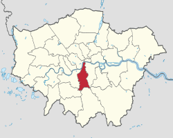 Lambeth shown within Greater London | |
| Coordinates: | |
| Sovereign state | United Kingdom |
| Constituent country | England |
| Region | London |
| Ceremonial county | Greater London |
| Created | 1 April 1965 |
| Admin HQ | Brixton Hill, Lambeth Town Hall |
| Government | |
| • Type | London borough council |
| • Body | Lambeth London Borough Council |
| • Leadership | Leader & Cabinet (Labour) |
| • Mayor | Annie Gallop |
| • London Assembly | Marina Ahmad (Labour) |
| • MPs | Florence Eshalomi (Labour Co-op) Helen Hayes (Labour) Bell Ribeiro-Addy (Labour) |
| • Council Leader | Cllr Claire Holland (Labour) |
| Area | |
| • Total | 10.36 sq mi (26.82 km2) |
| • Rank | 304th (of 309) |
| Population (mid-2019 est.) | |
| • Total | 326,034 |
| • Rank | 32nd (of 309) |
| • Density | 31,000/sq mi (12,000/km2) |
| • Ethnicity[1] | 39% White British 2.5% White Irish 0.1% White Gypsy or Irish Traveller 15.5% Other White 2.7% White & Black Caribbean 1.4% White & Black African 1.2% White & Asian 2.3% Other Mixed 1.6% Indian 1% Pakistani 0.7% Bangladeshi 1.5% Chinese 2% Other Asian 11.6% Black African 9.5% Black Caribbean 4.8% Other Black 0.6% Arab 1.9% Other |
| Time zone | UTC (GMT) |
| • Summer (DST) | UTC+1 (BST) |
| Postcodes | |
| Area code | 020 |
| ONS code | 00AY |
| GSS code | E09000022 |
| Police | Metropolitan Police |
| Website | www.lambeth.gov.uk |
History
Origins
Lambeth was part of the large ancient parish of Lambeth St Mary, the site of the archepiscopal Lambeth Palace, in the hundred of Brixton in the county of Surrey.[5] It was an elongated north–south parish with two miles (three kilometres) of River Thames frontage opposite the cities of London and Westminster. Lambeth became part of the Metropolitan Police District in 1829. It remained a parish for Poor Law purposes after the Poor Law Amendment Act 1834, and was governed by a vestry after the introduction of the Metropolitan Board of Works in 1855.[5]
Borough origins
Until 1889, Surrey included the present-day London borough of Lambeth. When the government drew the boundaries for the present London boroughs, it initially suggested that the Metropolitan Borough of Lambeth and the Metropolitan Borough of Southwark be merged into a new borough; the southern and eastern sections of the Metropolitan Borough of Wandsworth (including Clapham, Streatham and Tooting) would form another. South Shields town clerk R.S. Young was commissioned to make final recommendations to the government on the shape of the future London boroughs, and he noted that the Wandsworth council opposed the partition of its borough. However, Wandsworth's suggestion to merge Lambeth with the Metropolitan Borough of Battersea was rejected by both councils involved. Young believed that residents of Clapham and Streatham would be more familiar with Brixton than with Wandsworth, and recommended a new borough formed from the Metropolitan Borough of Lambeth and six wards and portions of two others from the Metropolitan Borough of Wandsworth.[6]
Political events
In 1979, the administration of Edward ("Red Ted") Knight organised the borough's first public demonstration against the Thatcher government.[7][8] In 1985 Knight's Labour administration was subjected to rate-capping, with its budget restricted by the government. Knight and most of the Labour councillors protested by refusing to propose budgets. As a result of the protest, 32 councillors were ordered to repay interest lost by the council due to budgeting delays and were disqualified from office for five years.[7]
In 1991, Joan Twelves' administration failed to collect the poll tax and opposed the war in the Persian Gulf.[7][8] The following year, Twelves and 12 other councillors were suspended from the local Labour Party by regional officials for advocating non-payment of the poll tax and other ideas.[7][9] Twelves' deputy leader at this time was John Harrison.[10]
From 1978 to 2002 the council comprised 64 members, elected from 20 three-member and two two-member wards. Before this, the council had 60 members elected from 20 three-member wards. Just before the 2010 election, its political balance was 37 Labour members, 18 Liberal Democrats, seven Conservatives and one Green, giving Labour an eleven-member majority. In the 2010 Lambeth Council election, Labour gained seats and the Liberal Democrats, Conservatives and Greens lost seats. In 2014 the Liberal Democrats lost their seats, Conservatives were reduced to three and the Greens to one. Labour, gaining seats from the Conservatives and Liberal Democrats, had 59 seats.
In the 2016 European Union referendum, Lambeth had the highest share of Remain votes in the United Kingdom at 78.62%, second to overseas territory Gibraltar's 95.9%.[11]
Geography
Lambeth is a long, thin borough, about three miles (five kilometres) wide and seven miles (eleven kilometres) long. Brixton is its civic centre, and there are other town centres. The largest shopping areas are (in order of size) Streatham, Brixton, Vauxhall, Clapham and West Norwood.
In the northern part of the borough are the central London districts of the South Bank, Vauxhall and Lambeth; in the south are the suburbs of Gipsy Hill, Streatham, West Dulwich and West Norwood. In between are the developed and inner-city districts of Brixton, Brixton Hill, Streatham Hill, Clapham, Clapham Park, Herne Hill, Stockwell, Tulse Hill and Kennington, each at different stages of gentrification with suburban and urban elements. Vauxhall and South Lambeth are central districts in the process of redevelopment with high-density business and residential property. Streatham lies between suburban London and inner-city Brixton, with the suburban and developed areas of Streatham, Streatham Hill and Streatham Vale.
The London Borough of Southwark lies to the east of the Borough of Lambeth. To the west is the London Borough of Wandsworth; to the south-west is the London Borough of Merton; and to the south is the London Borough of Croydon.
Parks and green space
Lambeth's open spaces include Brockwell Park and Lido, Streatham Common, half of Clapham Common, West Norwood Cemetery, Archbishop's Park, Norbury Park, Vauxhall Pleasure Gardens and Ruskin and Larkhall Park and Kennington Parks.
Landmarks
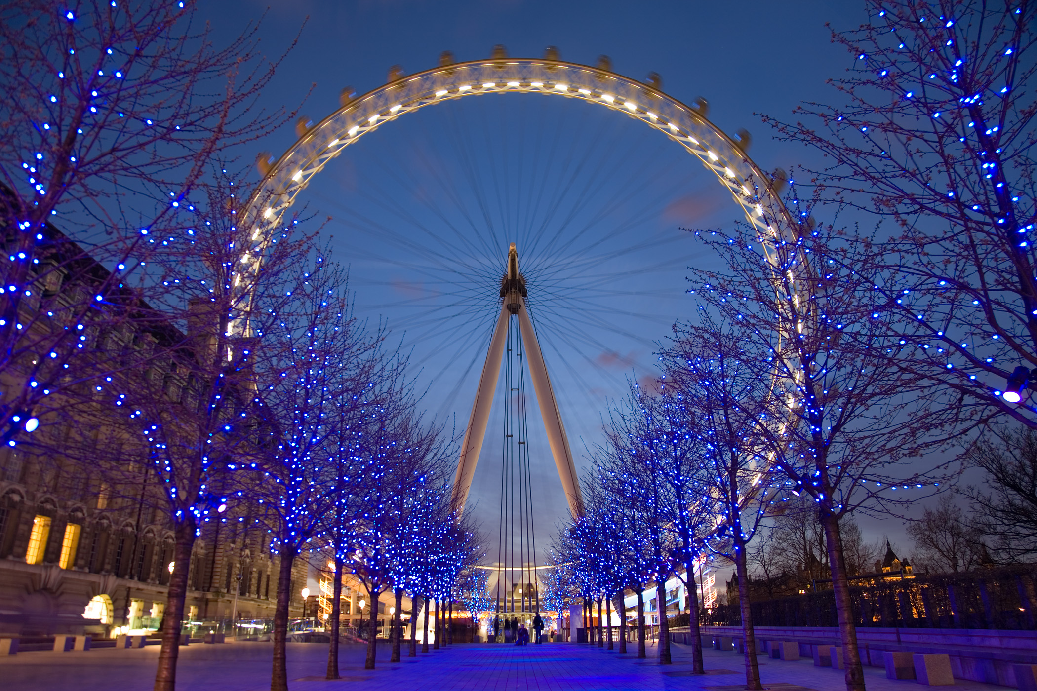
Along and around the South Bank, a tourist area has developed around the former Greater London Council headquarters of County Hall and the Southbank Centre and National Theatre. Also on the river is the London Eye and Shell Centre. Nearby is St Thomas' Hospital, Lambeth Palace and the Florence Nightingale Museum. Nearby is Brixton, home of Lambeth Town Hall and the Brixton Murals.

Landmark church buildings include:
- St Mary's, Lambeth (now the Garden Museum)
- The four "Waterloo Churches" in the former Lambeth Parish:
- St Matthew's, Brixton
- St Mark's, Kennington
- St Luke's, West Norwood
- St John's, Waterloo
- Holy Trinity, Clapham
- St Leonard's, Streatham
- Christ Church, Streatham Hill
- Christ Church (Church of England), Brixton Road, North Brixton
- All Saints' Church, West Dulwich (Church of England)
- Holy Trinity, Trinity Rise, Tulse Hill
- St John the Divine (Church of England), Vassall Road

The Oval cricket ground in Kennington is the home of Surrey County Cricket.
The Basaveshwara statue at the Albert Embankment erected by the former Mayor of Lambeth Neeraj Patil was unveiled by the Prime Minister of India on 14 November 2015.[12]
Demography

| Year | Pop. | ±% |
|---|---|---|
| 1801 | 34,135 | — |
| 1811 | 49,511 | +45.0% |
| 1821 | 68,458 | +38.3% |
| 1831 | 102,524 | +49.8% |
| 1841 | 131,131 | +27.9% |
| 1851 | 158,559 | +20.9% |
| 1861 | 204,252 | +28.8% |
| 1871 | 249,945 | +22.4% |
| 1881 | 295,637 | +18.3% |
| 1891 | 332,619 | +12.5% |
| 1901 | 357,316 | +7.4% |
| 1911 | 383,848 | +7.4% |
| 1921 | 388,779 | +1.3% |
| 1931 | 393,782 | +1.3% |
| 1941 | 355,970 | −9.6% |
| 1951 | 321,795 | −9.6% |
| 1961 | 315,184 | −2.1% |
| 1971 | 308,740 | −2.0% |
| 1981 | 244,153 | −20.9% |
| 1991 | 256,406 | +5.0% |
| 2001 | 266,170 | +3.8% |
| 2011 | 303,086 | +13.9% |
| Note:[13] | ||
Ethnicity
| Ethnic Group | 1991[14] | 2001[15] | 2011[16] | |||
|---|---|---|---|---|---|---|
| Number | % | Number | % | Number | % | |
| White: Total | 170,755 | 69.7% | 166,058 | 62.39% | 173,025 | 57.09% |
| White: British | – | – | 131,939 | 49.57% | 118,250 | 39.02% |
| White: Irish | – | – | 8,689 | 3.26% | 7,456 | 2.46% |
| White: Gypsy or Irish Traveller | – | – | – | – | 195 | 0.06% |
| White: Other | – | – | 25,430 | 9.55% | 47,124 | 15.55% |
| Asian or Asian British: Total | 14,937 | 6.1% | 15,526 | 5.83% | 20,938 | 6.91% |
| Asian or Asian British: Indian | 5208 | 5,316 | 2.00% | 4,983 | 1.64% | |
| Asian or Asian British: Pakistani | 1997 | 2,634 | 0.99% | 3,072 | 1.01% | |
| Asian or Asian British: Bangladeshi | 1658 | 2,169 | 0.81% | 2,221 | 0.73% | |
| Asian or Asian British: Chinese | 3086 | 3,362 | 1.26% | 4,573 | 1.51% | |
| Asian or Asian British: Other Asian | 2988 | 2,045 | 0.77% | 6,089 | 2.01% | |
| Black or Black British: Total | 53,432 | 21.8% | 68,554 | 25.76% | 78,542 | 25.91% |
| Black or Black British: African | 16021 | 30,836 | 11.59% | 35,187 | 11.61% | |
| Black or Black British: Caribbean | 30789 | 32,139 | 12.07% | 28,886 | 9.53% | |
| Black or Black British: Other Black | 6622 | 5,579 | 2.10% | 14,469 | 4.77% | |
| Mixed or British Mixed: Total | – | – | 12,854 | 4.83% | 23,160 | 7.64% |
| Mixed: White and Black Caribbean | – | – | 5,322 | 2.00% | 8,302 | 2.74% |
| Mixed: White and Black African | – | – | 2,159 | 0.81% | 4,301 | 1.42% |
| Mixed: White and Asian | – | – | 2,100 | 0.79% | 3,574 | 1.18% |
| Mixed: Other Mixed | – | – | 3,273 | 1.23% | 6,983 | 2.30% |
| Other: Total | 5,710 | 2.3% | 3,177 | 1.19% | 7,421 | 2.45% |
| Other: Arab | – | – | – | – | 1,728 | 0.57% |
| Other: Any other ethnic group | 5710 | 2.3% | 3,177 | 1.19% | 5,693 | 1.88% |
| Ethnic minority: Total | 74,079 | 30.2% | 100,111 | 37.61% | 130,061 | 42.91% |
| Total | 244,834 | 100% | 266,169 | 100.00% | 303,086 | 100.00% |
Language
| Language | 1992 | 2014 |
|---|---|---|
| English | 76.0% | 49.6% |
| Portuguese | 1.5% | 7.6% |
| Spanish | 0.9% | 5.1% |
| Somali | 0.1% | 4.5% |
| French | 1.0% | 3.7% |
| Yoruba | 3.2% | 3.4% |
| Akan/TwiFante | 1.5% | 2.7% |
| Polish | 0.1% | 2.6% |
| Arabic | 1.2% | 2.5% |
| Bengali | 1.9% | 1.6% |
Religion
| Religion | 2011[18] | |
|---|---|---|
| Number | % | |
| Christian | 160,944 | 53.10% |
| Buddhist | 2,963 | 0.98% |
| Hindu | 3,119 | 1.03% |
| Jewish | 1,134 | 0.37% |
| Muslim | 21,500 | 7.09% |
| Sikh | 440 | 0.14% |
| Other religion | 1,682 | 0.56% |
| No religion | 84,803 | 27.98% |
| Religion not stated | 26,501 | 8.74% |
| Total | 219,396 | 100.00% |
Sexuality
Lambeth is the local authority with the highest relative gay or lesbian population in the UK, at 5.5%, with the borough containing the gay village of Vauxhall and the area around Clapham Common.[19]
Arts
- South London Theatre, a community theatre in West Norwood
- National Theatre
- Southbank Centre
- Old Vic Theatre
- Young Vic Theatre
- Ballet Rambert
- British Film Institute
- Black Cultural Archives
- Beconsfield
- Gasworks Gallery
- Newport Street Gallery
- Ovalhouse theatre
- Cinema Museum
Civic affairs
Borough Council


Since 2002, Lambeth Borough Council has had 63 members elected in 21 three-member wards by means of a plurality bloc voting system. The wards are Bishop's, Brixton Hill, Clapham Common, Clapham Town, Coldharbour, Ferndale, Gipsy Hill, Herne Hill, Knight's Hill, Larkhall, Oval, Prince's, St Leonard's, Stockwell, Streatham Hill, Streatham South, Streatham Wells, Thornton, Thurlow Park, Tulse Hill and Vassall.
The independent Local Government Boundary Commission for England reviewed Lambeth’s electoral arrangements. The Commission’s recommendations have now passed into law and take effect on Thursday 5 May 2022, when council elections take place across the borough. Most wards will have a new name, 12 wards will be represented by 2 councillors, 13 wards will be represented by 3 councillors and Lambeth’s total number of councillors stays the same at 63.[20]
Civic council affairs
The council is run by a leader and cabinet, chaired by council leader Claire Holland. All cabinet members are from the ruling Labour Party who hold 55 of the 63 seats on Lambeth Council.
The Leader of the official Opposition is Jonathan Bartley (Green) and the leader of the Conservative group is Tim Briggs.
From 1994 to 2014, the Mayor of Lambeth was elected unanimously by their fellow councillors, with each of the three political parties supplying a candidate in rotation. According to the borough's website, this underscored the mayor's apolitical role and enables him or her to represent all the borough's citizens. Since 2014, the predominance of the Labour Party has meant that all subsequent Mayors have been members of the Labour group.
Coat of arms
The borough's coat of arms is that of the former Metropolitan Borough of Lambeth, with two gold stars (mullets) in the second and third quarters of the shield indicating the addition of the districts of Clapham and Streatham. Its motto is "Spectemur agendo" ("Let us be judged according to our conduct").
Westminster Parliament
The borough has three Parliamentary constituencies: Dulwich and West Norwood (shared with Southwark), Streatham, and Vauxhall.
Twinning
The former Metropolitan Borough of Lambeth and its successor have been twinned with the Vincennes district of Paris in France since 1955. Lambeth is also twinned with Bluefields, Nicaragua; Brooklyn, New York; and Spanish Town, Jamaica.
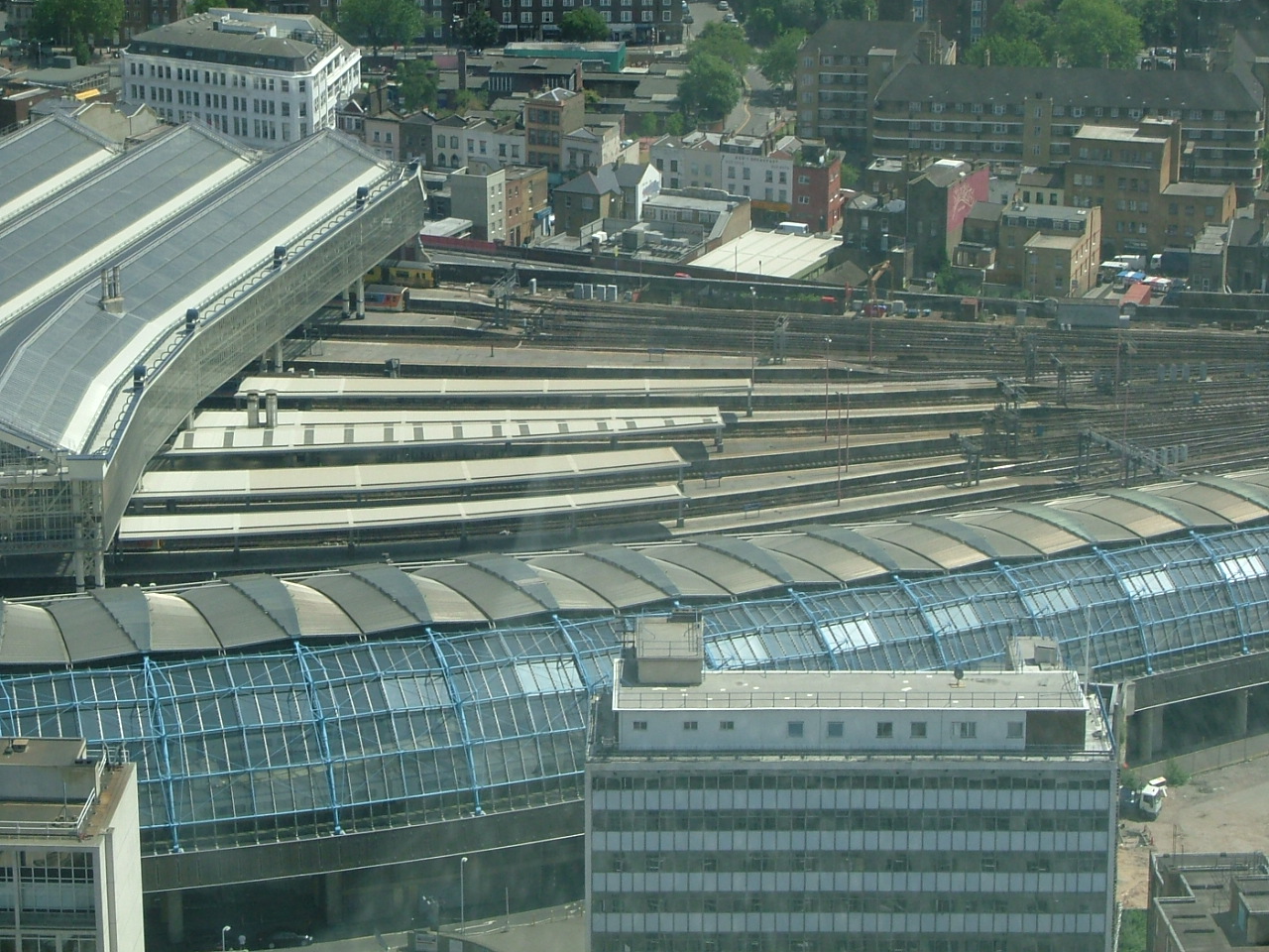
Transport
The borough covers London Waterloo railway station, the Waterloo tube station network and (until 2007) the London terminus for Eurostar. National Rail service in Lambeth is provided by South Western Railway, Southeastern, Southern, Thameslink and London Overground.
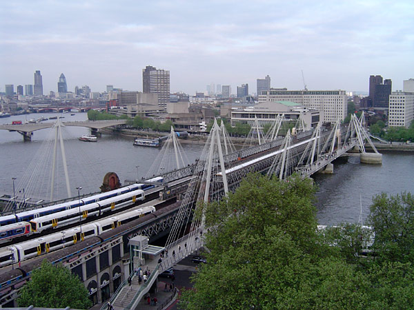
Bridges and tunnels

- Waterloo Bridge, incorporating the National Film Theatre
- Hungerford Bridge and Golden Jubilee Bridges
- Lambeth Bridge
- Westminster Bridge
- Vauxhall Bridge

Hungerford Bridge and Golden Jubilee Bridges, seen from the north
Railway stations
- Brixton
- Gipsy Hill
- Herne Hill
- Loughborough Junction
- Streatham
- Streatham Common
- Streatham Hill
- Tulse Hill
- Vauxhall
- Waterloo
- Waterloo East
- West Norwood
London Overground stations
Tube stations
Commuting
In March 2011, the primary forms of transport borough residents used to travel to work were the London Underground, metro, light rail or tram (21.4 percent of residents aged 16–74); bus, minibus or coach (10 percent); train (10 percent); automobile (8.6 percent); bicycle (5.7 percent), or walking (5.4 percent). A small percentage (3.2 percent) worked mainly at—or from—home.[21]
See also
- Lambeth London Borough Council
- List of districts in Lambeth
- List of schools in Lambeth
References
- 2011 Census: Ethnic group, local authorities in England and Wales, Office for National Statistics (2012). See Classification of ethnicity in the United Kingdom for the full descriptions used in the 2011 Census.
- "Lambeth". Collins Dictionary.
- "Where is the Centre of London? An Update | Londonist". Archived from the original on 30 May 2016. Retrieved 6 May 2016.
- BBC. "Where Is The Centre Of London?".
- Youngs, Frederic (1979). Guide to the Local Administrative Units of England. Vol. I: Southern England. London: Royal Historical Society. ISBN 0-901050-67-9.
- "London Government: The London Boroughs", Ministry of Housing and Local Government, HMSO, 1962. See in particular paragraphs 51–57.
- "The rise and fall of Red Ted's loony lefties". Independent.co.uk. 29 July 1995.
- Kate Hoey MP and Lambeth Labour Party – Brian Deer investigates. Briandeer.com (8 August 1993). Retrieved on 17 July 2013.
- Bennett, Will (29 July 1995). "The rise and fall of Red Ted's loony lefties". The Independent.
- GLATUC News. Glatuc.org.uk. Retrieved on 17 July 2013.
- "EU referendum: full results and analysis". The Guardian. 24 June 2016.
- "PM unveils Basaveshwara Statue, inaugurates Dr Ambedkar Memorial in London". PMindia. 14 November 2014. Retrieved 22 November 2019.
- "Lambeth: Total Population". A Vision of Britain Through Time. Great Britain Historical GIS Project. Retrieved 6 September 2011.
- "1991 census – theme tables". NOMIS. Retrieved 20 January 2017.
- "KS006 - Ethnic group". NOMIS. Retrieved 30 January 2016.
- "Ethnic Group by measures". NOMIS. Retrieved 2 September 2014.
- Association, Local Government. "Lambeth State of the Borough 2016". lginform.local.gov.uk. Retrieved 11 April 2022.
- "2011 census - theme tables". Retrieved 5 September 2014.
- Ross, Alice (19 April 2017). "Out in the country – rural hotspots found as gay population mapped". The Guardian. Retrieved 11 July 2019.
- "New electoral wards | Lambeth Council". beta.lambeth.gov.uk. Retrieved 11 April 2022.
- "2011 Census: QS701EW Method of travel to work, local authorities in England and Wales". Office for National Statistics. Retrieved 23 November 2013. Percentages are of all residents aged 16–74 including those not in employment. Respondents could only pick one mode, specified as the journey's longest part by distance.
External links
- Lambeth.gov.uk London Borough of Lambeth Official Website
- electionmemory.com Independent Lambeth Council Elections Forum
- General information on Lambeth parks and green spaces
- Community Police Consultative Group for Lambeth Independent forum for community and statutory agencies to address community safety and policing issues.
| Districts | 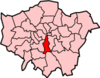 | |
|---|---|---|
| Attractions |
| |
| Bridges |
| |
| Parks and open spaces |
| |
| Constituencies |
| |
| Tube, rail, and riverboat stations | ||
| Other topics |
| |
| ||
На других языках
- [en] London Borough of Lambeth
[ru] Ламбет (боро Лондона)
Ло́ндонский бо́ро Ла́мбет (англ. London Borough of Lambeth, произношение (инф.)) — один из 32 лондонских боро, находится во внутреннем Лондоне на южном берегу Темзы, вверх по течению от Саутварка, напротив Вестминстерского дворца. С Миллбанком его соединяет Ламбетский мост, а с Вестминстером — мост Ватерлоо, а на набережной стоит одноимённый вокзал, откуда отходят поезда в Европу. Отсюда происходит неформальное название Ламбета — Ватерлоо (англ. Waterloo).Другой контент может иметь иную лицензию. Перед использованием материалов сайта WikiSort.org внимательно изучите правила лицензирования конкретных элементов наполнения сайта.
WikiSort.org - проект по пересортировке и дополнению контента Википедии