world.wikisort.org - United_Kingdom
Calveley is a village and civil parish in the unitary authority of Cheshire East and the ceremonial county of Cheshire, England. The village lies 5½ miles to the north west of Nantwich. The parish also includes parts of the settlements of Barrets Green and Wardle Bank.[1] The total population is 280 people. The area is largely agricultural and includes a short stretch of the Shropshire Union Canal. There is an Anglican parish church, a primary school and a public house. Nearby villages include Alpraham, Bunbury, Haughton and Wardle.
| Calveley | |
|---|---|
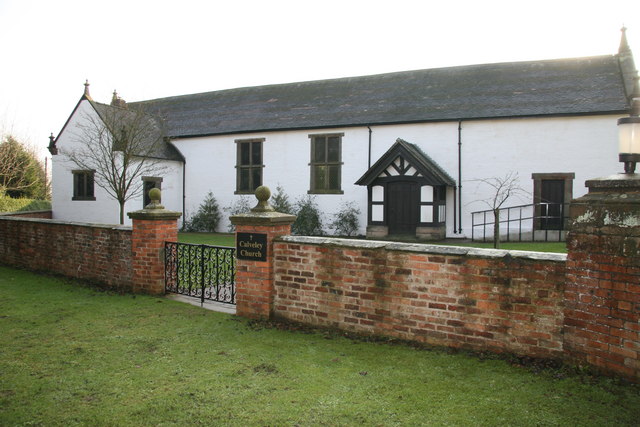 Calveley Church | |
 Calveley Location within Cheshire | |
| Population | 280 (2011) |
| OS grid reference | SJ591589 |
| Civil parish |
|
| Unitary authority |
|
| Ceremonial county |
|
| Region |
|
| Country | England |
| Sovereign state | United Kingdom |
| Post town | TARPORLEY |
| Postcode district | CW6 |
| Dialling code | 01829 |
| Police | Cheshire |
| Fire | Cheshire |
| Ambulance | North West |
| UK Parliament |
|
History

Watfield Pavement, a stone road believed to have originally formed part of a Roman road from Chester to Chesterton in Staffordshire, passed through the parish.[2] Originally held by the de Calveleys, the manor passed by marriage to the Davenport family in 1369.[3] Their seat was at Calveley Hall. John Wesley is supposed to have visited the hall in 1749.[4] The original hall was demolished at the end of the 18th century, and its replacement was also demolished in 1952.[3][4][5]
A railway station at the village opened between 1840 and 1842. It remained open for passenger use until 7 March 1960 and for goods until 2 November 1964.[6] There was a canal wharf to transfer goods between the canal and the railway,[7] and from 1928 a siding into the United Dairies milk depot.
Next to the station was a sizeable steam saw mill owned by Messrs Wright, Aldred & Son which manufactured bobbins and general wood 'turnery' until it was closed and the contents auctioned in 1884.[8] Known as the "bobbin factory", the name stuck even when the works was later converted to a milk depot. A further auction of saw mill equipment, steam engine, and sawn timber in 1896 suggests that the mill had continued as a saw mill after the 1884 auction.[9]
The milk depot at Calveley run by United Dairies was a major employer, and collected Cheshire milk from a wide area. The origins seems to be the Tilstone Bank Dairy owned by Mr F.T. Walley, who sold it to William Price of the Great Western and Metropolitan Dairies Company in 1916 (already part of United Dairies), and relocated the dairy to the former saw mill at Calveley in 1918, with Mr Walley assuming the role of district manager, with his son H.A. Walley as Calveley depot manager. The siding into the depot was laid in 1928, and capacity was progressively increased reaching 50,000 gallons a day which were sent by rail to the London, Scrubs Lane, depot. Any excess milk went to the creameries at Whitchurch or Ellesmere for cheese-making. [10] The works was closed in October 1965 with the loss of 100 jobs, it was owned at the time by Unigate Creameries, who had taken it over the previous April.[11]
Governance
Calveley is administered by the Calveley Parish Council.[12] From 1974 the civil parish was served by Crewe and Nantwich Borough Council, which was succeeded on 1 April 2009 by the unitary authority of Cheshire East.[13] Calveley falls in the parliamentary constituency of Eddisbury,[14] which has been represented by Edward Timpson since 2019,[15] after being represented by Stephen O'Brien (1999–2015) and Antoinette Sandbach (2015–19).
Geography and transport

Most of the civil parish is agricultural, with Fox Covert, Old Covert, Ladyacre Wood and several smaller areas of woodland, as well as numerous scattered small meres and ponds. Ankersplatt Brook forms part of the north-western boundary; Bankside Brook runs in the north of the parish, also forming a short stretch of the north-eastern boundary; and a tributary of Crowton Brook forms part of the south-eastern boundary. The terrain slopes gently from a high point of around 65 metres at SJ60005952, near Fields Farm, to low points of around 40 metres in the north of the parish and of around 50 metres at the south-western boundary.[16]
The Shropshire Union Canal and the A51 (Nantwich Road) run for a few hundred metres across the south-west corner of the civil parish, near Calveley village. The road and canal then run side by side along the parish's south-western boundary, with this stretch of the canal falling within the adjacent parish of Wardle. The Crewe–Chester railway follows a similar line, around 100–200 metres inside the parish boundary, and is crossed by an accommodation bridge at SJ60035823. There is a petrol station on the A51 near Tweedale Canal Bridge. Calveley Hall Lane runs from the A51 in Wardle via Wardle Bank to Long Lane, which forms part of the parish's north-western boundary, looping back to the A51 within the parish of Alpraham. Calveley Green Lane connects Calveley Hall Lane with Cholmondeston.[16]
Demography

According to the 2001 census, the parish had a population of 269,[17] rising to 280 in 107 households in the 2011 census.[18] This represents a decline from the 1901 population; the historical population figures are 144 (1801), 212 (1851), 312 (1901) and 202 (1951).[1] The population density was 0.4 persons/hectare in 2011, well below the average of 3.2 persons/hectare for Cheshire East.[18]
Places of worship
Calveley Church on Calveley Hall Lane (at SJ6038459270) dates from the 17th century. Originally a barn, it became a coach house to Calveley Hall and, in around 1838, the hall's private chapel. When the hall was demolished, it became an Anglican parish church. It is listed at grade II, the lowest grade.[19][20]
Other landmarks

The Woodlands is a grade-II-listed red-brick farmhouse dating from the late 18th century.[21] The mid-19th-century brick stables of Calveley Hall survive; they are also listed at grade II.[22]
Education
Calveley Primary Academy on Calveley Green Lane serves the civil parish, as well as the adjacent parishes of Alpraham, Cholmondeston, Stoke, Wardle and Wettenhall.[23] Calveley falls within the catchment area of Tarporley High School in Tarporley for secondary education.[24]
See also
- Listed buildings in Calveley
- RAF Calveley, derelict former RAF airfield in the adjacent parish of Wardle
References
- Calveley, UK & Ireland Genealogy, retrieved 14 August 2007
- "Watfield Pavement", Revealing Cheshire's Past, Cheshire East and Cheshire West and Chester councils, archived from the original on 19 October 2016, retrieved 14 October 2016
- Gastrell 1845, p. 218
- Cheshire Federation of Women's Institutes 1990, pp. 16–17
- Calveley Church, St Boniface's Church, Bunbury, retrieved 14 October 2016
- Calveley, disused-stations.org
- Fisher 2009, p. 157
- Sales by Auction, Chester Courant, 25 August 1886, p4
- Sales by Auction, Crewe Chronicle, 08 February 1896, p4
- The United Dairies - The Cheshire Depot at Calveley, Crewe Chronicle, 28 January 1933, p9
- Calveley Milk Depot to Close, Nantwich Chronicle, 09 September 1965, p1
- Calveley Parish Council, Cheshire East Council, retrieved 14 October 2016
- Cheshire (Structural Changes) Order 2008 Archived May 17, 2009, at the Wayback Machine
- "Eddisbury", Interactive Mapping, Cheshire East Council & Cheshire West and Chester Council, archived from the original on 3 October 2016, retrieved 12 October 2016
- Eddisbury Parliamentary constituency, BBC, retrieved 19 December 2019
- Explorer 257: Crewe & Nantwich: Whitchurch & Tattenhall, Ordnance Survey
- Neighbourhood Statistics: Calveley CP (accessed 12 August 2007)
- "Area: Calveley (Parish): Key Figures for 2011 Census: Key Statistics", Neighbourhood Statistics, Office for National Statistics, 2011, retrieved 14 October 2016
- Calveley Church, Historic England, retrieved 13 October 2016
- Hartwell et al. 2011, pp. 200–1
- The Woodlands, Historic England, retrieved 14 October 2016
- Former stables of Calveley Hall, Historic England, retrieved 14 October 2016
- "Calveley Primary Academy", Interactive Mapping, Cheshire East Council & Cheshire West and Chester Council, archived from the original on 19 October 2016, retrieved 14 October 2016
- "Tarporley High School and 6th Form College", Interactive Mapping, Cheshire East Council & Cheshire West and Chester Council, archived from the original on 18 October 2016, retrieved 14 October 2016
Sources
- Cheshire Federation of Women's Institutes. The Cheshire Village Book (Countryside Books and CFWI; 1990) (ISBN 1-85306-075-5)
- Stuart Fisher. The Canals of Britain: A Comprehensive Guide (A&C Black; 2009) (ISBN 1408105179)
- Francis Gastrell. Notitia Cestriensis, Or, Historical Notices of the Diocese of Chester: Cheshire (F. R. Raines, ed.) (Chetham Society; 1845)
- Clare Hartwell, Matthew Hyde, Edward Hubbard, Nikolaus Pevsner. The Buildings of England: Cheshire (Yale University Press; 2011) (ISBN 978-0-300-17043-6)
| Unitary authorities |
|
|---|---|
| Major settlements |
|
| Rivers | |
| Topics |
|
Другой контент может иметь иную лицензию. Перед использованием материалов сайта WikiSort.org внимательно изучите правила лицензирования конкретных элементов наполнения сайта.
WikiSort.org - проект по пересортировке и дополнению контента Википедии