world.wikisort.org - Ukraine
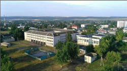
Shyriaieve (Ukrainian: Ширяєве, Russian: Ширяево) is an urban-type settlement in the west of Odesa Oblast, Ukraine. Population: 6,402 (2021 est.)[1]
Shyriaieve
Ширяєве | |
|---|---|
Urban-type settlement | |
 | |
|
Coat of arms | |
 Shyriaieve  Shyriaieve | |
| Coordinates: 47°23′16″N 30°11′28″E | |
| Country | |
| Oblast | |
| Raion | Berezivka Raion |
| Population (2021)[1] | |
| • Total | 6,402 |
| Time zone | UTC+2 (EET) |
| • Summer (DST) | UTC+3 (EEST) |
Shyriaieve is located on the banks of the Velykyi Kuialnyk.
History
Shyriaieve was founded in the end of the 18th century as Stepanivka (Russian: Stepanovka), named after the landowner Stepan Shyriay.[2] The area was settled after 1792, when the lands between the Southern Bug and the Dniester were transferred to Russia according to the Iasi Peace Treaty. The area was included in Tiraspolsky Uyezd, which belonged to Yekaterinoslav Viceroyalty until 1795, Voznesensk Viceroyalty until 1796, Novorossiya Governorate until 1803, and Kherson Governorate until 1920. In 1834, the area was transferred to newly established Ananyevsky Uyezd. In the middle of the 19th century it was formally renamed Shiriaieve (Shyriaievo).
On 16 April 1920, Odesa Governorate split off, and Ananiv Uyezd was moved to Odessa Governorate, where it was abolished in 1921. In 1923, uezds in Ukrainian Soviet Socialist Republic were abolished, and the governorates were divided into okruhas.
Economy
Transportation
Shyriaieve has access to the M05 highway (Ukraine) which connects Kyiv and Odessa. Other roads connect it with Podilsk, Ananiv, and Berezivka.
References
- Чисельність наявного населення України на 1 січня 2021 [Number of Present Population of Ukraine, as of January 1, 2021] (PDF) (in Ukrainian and English). Kyiv: State Statistics Service of Ukraine.
- "О Ширяево" (in Russian). Информационный ресурс п.г.т. Ширяево. Retrieved 25 May 2016.
Administrative center: Odesa | ||
| Raions | ||
| Hromadas | ||
| Cities | ||
| Urban-type settlements |
| |
Authority control | |
|---|---|
| General |
|
| National libraries | |
На других языках
[de] Schyrjajewe
Schyrjajewe (ukrainisch Ширяєве; russisch Ширяево .mw-parser-output .Latn{font-family:"Akzidenz Grotesk","Arial","Avant Garde Gothic","Calibri","Futura","Geneva","Gill Sans","Helvetica","Lucida Grande","Lucida Sans Unicode","Lucida Grande","Stone Sans","Tahoma","Trebuchet","Univers","Verdana"}Schirjajewo) ist eine Siedlung städtischen Typs und bis Juli 2021 das administrative Zentrum des gleichnamigen Rajons in der ukrainischen Oblast Odessa mit etwa 6.800 Einwohnern (2013).[1]- [en] Shyriaieve
[es] Shyriaieve
Shyriaieve (ucraniano: Ширяєве) es una localidad del Raión de Berezivka en el óblast de Odesa del sur de Ucrania. Es el centro administrativo del Raión de Shyriaieve.[ru] Ширяево (Одесская область)
Ширя́ево (укр. Ширяєве) — поселок городского типа, административный центр Ширяевского района Одесской области Украины.Другой контент может иметь иную лицензию. Перед использованием материалов сайта WikiSort.org внимательно изучите правила лицензирования конкретных элементов наполнения сайта.
WikiSort.org - проект по пересортировке и дополнению контента Википедии