world.wikisort.org - Ukraine
Rozdilna (Ukrainian: Розді́льна, transliteration Rozdíl’na, pronounced [roz⁽ʲ⁾ˈd⁽ʲ⁾ilʲ.nɐ]) is a small city in Odesa Oblast (province) of southern Ukraine. It is the administrative center of Rozdilna Raion (district), and was founded in 1863. Population: 17,593 (2021 est.)[1]
Rozdilna
Розді́льна | |
|---|---|
 | |
 Flag  Coat of arms | |
 Rozdilna Location in Ukraine  Rozdilna Rozdilna (Ukraine) | |
| Coordinates: 46°50′55″N 30°4′45″E | |
| Country | |
| Oblast | |
| City | Rozdilna Raion |
| Area | |
| • Total | 7.2 km2 (2.8 sq mi) |
| Elevation | 134 m (440 ft) |
| Population (2021) | |
| • Total | 17,593 |
| Time zone | UTC+2 (EET) |
| • Summer (DST) | UTC+3 (EEST) |
| Postal code | 67400 |
| Area code | +380-04853 |
| Website | rozdilna-rada |
History
- Rozdilna in 1914:
 Rozdilna train station
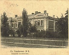 The Machinist's House
 St. Nicholas' church


Climate
| Climate data for Rozdilna (1981–2010) | |||||||||||||
|---|---|---|---|---|---|---|---|---|---|---|---|---|---|
| Month | Jan | Feb | Mar | Apr | May | Jun | Jul | Aug | Sep | Oct | Nov | Dec | Year |
| Average high °C (°F) | 0.5 (32.9) |
2.2 (36.0) |
7.7 (45.9) |
15.5 (59.9) |
22.2 (72.0) |
25.7 (78.3) |
28.2 (82.8) |
27.9 (82.2) |
21.9 (71.4) |
15.2 (59.4) |
7.3 (45.1) |
2.0 (35.6) |
14.7 (58.5) |
| Daily mean °C (°F) | −2.4 (27.7) |
−1.4 (29.5) |
3.1 (37.6) |
9.9 (49.8) |
16.1 (61.0) |
19.8 (67.6) |
22.2 (72.0) |
21.7 (71.1) |
16.1 (61.0) |
10.1 (50.2) |
3.8 (38.8) |
−0.8 (30.6) |
9.9 (49.8) |
| Average low °C (°F) | −4.8 (23.4) |
−4.3 (24.3) |
−0.2 (31.6) |
5.5 (41.9) |
10.8 (51.4) |
14.6 (58.3) |
16.9 (62.4) |
16.4 (61.5) |
11.4 (52.5) |
6.4 (43.5) |
1.1 (34.0) |
−3.2 (26.2) |
5.9 (42.6) |
| Average precipitation mm (inches) | 30.3 (1.19) |
31.4 (1.24) |
30.0 (1.18) |
31.8 (1.25) |
40.4 (1.59) |
66.0 (2.60) |
63.3 (2.49) |
45.6 (1.80) |
54.3 (2.14) |
36.9 (1.45) |
37.7 (1.48) |
35.2 (1.39) |
502.9 (19.80) |
| Average precipitation days (≥ 1.0 mm) | 6.3 | 6.3 | 5.9 | 6.2 | 6.8 | 7.6 | 6.8 | 4.4 | 5.3 | 4.7 | 5.8 | 6.2 | 72.3 |
| Average relative humidity (%) | 84.0 | 80.8 | 75.8 | 67.4 | 64.5 | 66.2 | 63.3 | 61.8 | 69.5 | 76.3 | 83.9 | 85.4 | 73.2 |
| Source: World Meteorological Organization[2] | |||||||||||||
References
- Чисельність наявного населення України на 1 січня 2021 / Number of Present Population of Ukraine, as of January 1, 2021 (PDF) (in Ukrainian and English). Kyiv: State Statistics Service of Ukraine.
- "World Meteorological Organization Climate Normals for 1981–2010". World Meteorological Organization. Archived from the original on 17 July 2021. Retrieved 17 July 2021.
External links
Administrative center: Odesa | ||
| Raions | ||
| Hromadas | ||
| Cities |
| |
| Urban-type settlements |
| |
This article about a location in Odesa Oblast is a stub. You can help Wikipedia by expanding it. |
На других языках
[de] Rosdilna
Rosdilna (ukrainisch Роздільна; russisch Раздельная/Rasdelnaja) ist eine Stadt im Süden der Ukraine, etwa 66 Kilometer nordwestlich von Odessa. Sie ist Zentrum des gleichnamigen Rajons Rosdilna und liegt nahe der Grenze zur Republik Moldau an einem Eisenbahnknotenpunkt.- [en] Rozdilna
[ru] Раздельная
Разде́льная (укр. Розді́льна) — приграничный город[6] в Одесской области Украины. Административный центр Раздельнянской городской общины и Раздельня́нского района. Здесь расположена узловая станция Одесской железной дороги, являющаяся узлом международного транспортного коридора[7].mw-parser-output .ts-Переход img{margin-left:.285714em}[⇨]. Железная дорога разделяет город с юго-востока на северо-запад практически на две равные по площади части. Также через город проходит автодорога территориального значения Т-1618[8].Текст в блоке "Читать" взят с сайта "Википедия" и доступен по лицензии Creative Commons Attribution-ShareAlike; в отдельных случаях могут действовать дополнительные условия.
Другой контент может иметь иную лицензию. Перед использованием материалов сайта WikiSort.org внимательно изучите правила лицензирования конкретных элементов наполнения сайта.
Другой контент может иметь иную лицензию. Перед использованием материалов сайта WikiSort.org внимательно изучите правила лицензирования конкретных элементов наполнения сайта.
2019-2026
WikiSort.org - проект по пересортировке и дополнению контента Википедии
WikiSort.org - проект по пересортировке и дополнению контента Википедии