world.wikisort.org - South_Africa
Ulundi, also known as Mahlabathini, is a town in the Zululand District Municipality. At one time the capital of Zulu Kingdom[2] in South Africa and later the capital of the Bantustan of KwaZulu, Ulundi now lies in KwaZulu-Natal Province (of which, from 1994 to 2004, it alternated with Pietermaritzburg as the provincial capital). The town now includes Ulundi Airport, a three-star hotel, and some museums amongst its sights. In the 2001 Census, the population of the town was recorded as 18,420.[3]
This article needs additional citations for verification. (November 2009) |
Ulundi
oLundi | |
|---|---|
 Ulundi  Ulundi | |
| Coordinates: 28°19′S 31°25′E | |
| Country | South Africa |
| Province | KwaZulu-Natal |
| District | Zululand |
| Municipality | Ulundi |
| Area | |
| • Total | 16.62 km2 (6.42 sq mi) |
| Elevation | 540 m (1,770 ft) |
| Population (2011)[1] | |
| • Total | 19,840 |
| • Density | 1,200/km2 (3,100/sq mi) |
| Racial makeup (2011) | |
| • Black African | 98.9% |
| • Coloured | 0.3% |
| • Indian/Asian | 0.2% |
| • White | 0.2% |
| • Other | 0.4% |
| First languages (2011) | |
| • Zulu | 93.4% |
| • English | 2.6% |
| • S. Ndebele | 1.1% |
| • Other | 2.9% |
| Time zone | UTC+2 (SAST) |
| PO box | 3838 |
| Area code | 035 |
History
When Cetshwayo became king of the Zulus on 1 September 1873, he created, as was customary, a new capital for the nation, naming it "Ulundi" ("The high place"). On 4 July 1879, in the Battle of Ulundi (the final battle of the Anglo-Zulu War), the British Army captured the royal kraal and razed it to the ground.
Nearby is Ondini, where King Mpande, Cetshwayo's father, had his kraal. A large Zulu hut now is on the site.
Climate
Köppen-Geiger climate classification system classifies its climate as humid subtropical (Cfa).[4] It is rainier in the warmer months.
| Climate data for Ulundi | |||||||||||||
|---|---|---|---|---|---|---|---|---|---|---|---|---|---|
| Month | Jan | Feb | Mar | Apr | May | Jun | Jul | Aug | Sep | Oct | Nov | Dec | Year |
| Average high °C (°F) | 28.2 (82.8) |
28.3 (82.9) |
27.3 (81.1) |
25.9 (78.6) |
24.3 (75.7) |
22.4 (72.3) |
22.5 (72.5) |
23.8 (74.8) |
25.0 (77.0) |
25.7 (78.3) |
26.3 (79.3) |
27.6 (81.7) |
25.6 (78.1) |
| Daily mean °C (°F) | 22.9 (73.2) |
23.1 (73.6) |
22.1 (71.8) |
20.3 (68.5) |
18.2 (64.8) |
16.0 (60.8) |
16.1 (61.0) |
17.2 (63.0) |
18.8 (65.8) |
19.9 (67.8) |
20.9 (69.6) |
22.1 (71.8) |
19.8 (67.6) |
| Average low °C (°F) | 17.6 (63.7) |
17.9 (64.2) |
16.9 (62.4) |
14.8 (58.6) |
12.2 (54.0) |
9.7 (49.5) |
9.7 (49.5) |
10.7 (51.3) |
12.6 (54.7) |
14.1 (57.4) |
15.6 (60.1) |
16.7 (62.1) |
14.0 (57.3) |
| Average precipitation mm (inches) | 123 (4.8) |
109 (4.3) |
90 (3.5) |
49 (1.9) |
28 (1.1) |
18 (0.7) |
18 (0.7) |
30 (1.2) |
56 (2.2) |
98 (3.9) |
110 (4.3) |
115 (4.5) |
844 (33.1) |
| Source: Climate-Data.org (altitude: 535m)[4] | |||||||||||||
References
- "Main Place Ulundi". Census 2011.
- Lyde, Lionel William (1907). "South Africa". A Geography of Africa. Adam and Charles Black. p. 97.
- "Main Place 'Ulundi Part 1'". Census 2001. Retrieved 3 June 2011.
- "Climate: Ulundi – Climate graph, Temperature graph, Climate table". Climate-Data.org. Retrieved 10 December 2013.
External links
- Battles around Ulundi
- Chisholm, Hugh, ed. (1911). . Encyclopædia Britannica (11th ed.). Cambridge University Press.
Municipalities and communities of Zululand District Municipality, KwaZulu-Natal | ||
|---|---|---|
District seat: Ulundi | ||
| Ulundi | 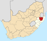 | |
| Nongoma | ||
| Abaqulusi | ||
| uPhongolo | ||
| EDumbe | ||
Authority control | |
|---|---|
| General |
|
| National libraries | |
This KwaZulu-Natal location article is a stub. You can help Wikipedia by expanding it. |
На других языках
[de] Ulundi
Ulundi ist eine Stadt im Distrikt Zululand, Provinz KwaZulu-Natal in Südafrika. Sie war von 1994 bis 2004 gemeinsam mit Pietermaritzburg Hauptstadt der Provinz. Die multikulturell geprägte Stadt ist zudem Sitz des Oberhauptes der Zulu, König Misuzulu Zulu. 2011 hatte Ulundi 19.840 Einwohner.[1]- [en] Ulundi
[ru] Улунди
Улунди (англ. Ulundi) — город на востоке Южно-Африканской Республики, на территории провинции Квазулу-Натал. Административный центр района Зулуленд.Другой контент может иметь иную лицензию. Перед использованием материалов сайта WikiSort.org внимательно изучите правила лицензирования конкретных элементов наполнения сайта.
WikiSort.org - проект по пересортировке и дополнению контента Википедии