world.wikisort.org - South_Africa
Mahlabatini is a small town in KwaZulu-Natal, South Africa. It was established in 1898 by the British.
This article needs additional citations for verification. (December 2009) |
Mahlabatini | |
|---|---|
 Mahlabatini  Mahlabatini | |
| Coordinates: 28°15′S 31°26′E | |
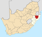
| Country | South Africa |
| Province | KwaZulu-Natal |
| District | Zululand |
| Municipality | Ulundi |
| Area | |
| • Total | 8.94 km2 (3.45 sq mi) |
| Population (2011)[1] | |
| • Total | 1,511 |
| • Density | 170/km2 (440/sq mi) |
| Racial makeup (2011) | |
| • Black African | 98.4% |
| • Coloured | 0.7% |
| • Indian/Asian | 0.1% |
| • White | 0.6% |
| • Other | 0.2% |
| First languages (2011) | |
| • Zulu | 96.7% |
| • Other | 3.3% |
| Time zone | UTC+2 (SAST) |
| PO box | 3865 |
| Area code | 035 |
Village 48 km south-west of Nongoma. Established as a Norwegian mission station, it became the seat of magistracy of the Mahlabatini district. The name is Zulu, said to mean ‘country of white, sandy soil’. Known locally as Mashona, situated on the Mashona Engashoni Ridge.[2]
Neighbouring localities include Ulundi (10 km); Melmoth (55 km); Nongoma (53 km); Hlabisa (99 km).[3]
References
- "Main Place Mahlabatini". Census 2011.
- "Dictionary of Southern African Place Names (Public Domain)". Human Science Research Council. p. 291.
- Travel distances from Mahlabatini
Municipalities and communities of Zululand District Municipality, KwaZulu-Natal | ||
|---|---|---|
District seat: Ulundi | ||
| Ulundi |
|  |
| Nongoma | ||
| Abaqulusi | ||
| uPhongolo | ||
| EDumbe |
| |
This KwaZulu-Natal location article is a stub. You can help Wikipedia by expanding it. |
Текст в блоке "Читать" взят с сайта "Википедия" и доступен по лицензии Creative Commons Attribution-ShareAlike; в отдельных случаях могут действовать дополнительные условия.
Другой контент может иметь иную лицензию. Перед использованием материалов сайта WikiSort.org внимательно изучите правила лицензирования конкретных элементов наполнения сайта.
Другой контент может иметь иную лицензию. Перед использованием материалов сайта WikiSort.org внимательно изучите правила лицензирования конкретных элементов наполнения сайта.
2019-2025
WikiSort.org - проект по пересортировке и дополнению контента Википедии
WikiSort.org - проект по пересортировке и дополнению контента Википедии