world.wikisort.org - South_Africa
Hlobane is a town in Zululand District Municipality in the KwaZulu-Natal province of South Africa.
Hlobane | |
|---|---|
 Hlobane  Hlobane | |
| Coordinates: 27.710°S 30.999°E | |
| Country | South Africa |
| Province | KwaZulu-Natal |
| District | Zululand |
| Municipality | Abaqulusi |
| Area | |
| • Total | 17.08 km2 (6.59 sq mi) |
| Population (2011)[1] | |
| • Total | 7,628 |
| • Density | 450/km2 (1,200/sq mi) |
| Racial makeup (2011) | |
| • Black African | 99.6% |
| • White | 0.2% |
| • Other | 0.1% |
| First languages (2011) | |
| • Zulu | 96.2% |
| • Other | 3.8% |
| Time zone | UTC+2 (SAST) |
| PO box | 3145 |
| Area code | 034 |
Coal-mining centre 27 km east of Vryheid and 31 km south-west of Louwsburg. The locality was known as such in the 19th century and the name applied to the town in 1924. Of Zulu origin, it is said by some to mean ‘beautiful place’, and by others ‘place of dispute’.[2] It was the scene of the battle of Hlobane in the Zulu War, on 28 March 1879.
Bibliography
- Ian Knight, Ian Castle, Rorke's Drift : Zulu War, Leo Cooper, UK, 2000. ISBN 9780850526554.
References
- "Main Place Hlobane". Census 2011.
- "Dictionary of Southern African Place Names (Public Domain)". Human Science Research Council. p. 211.
External links
Municipalities and communities of Zululand District Municipality, KwaZulu-Natal | ||
|---|---|---|
District seat: Ulundi | ||
| Ulundi | 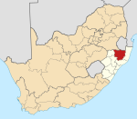 | |
| Nongoma |
| |
| Abaqulusi |
| |
| uPhongolo | ||
| EDumbe |
| |
| Authority control |
|
|---|
This KwaZulu-Natal location article is a stub. You can help Wikipedia by expanding it. |
Текст в блоке "Читать" взят с сайта "Википедия" и доступен по лицензии Creative Commons Attribution-ShareAlike; в отдельных случаях могут действовать дополнительные условия.
Другой контент может иметь иную лицензию. Перед использованием материалов сайта WikiSort.org внимательно изучите правила лицензирования конкретных элементов наполнения сайта.
Другой контент может иметь иную лицензию. Перед использованием материалов сайта WikiSort.org внимательно изучите правила лицензирования конкретных элементов наполнения сайта.
2019-2025
WikiSort.org - проект по пересортировке и дополнению контента Википедии
WikiSort.org - проект по пересортировке и дополнению контента Википедии