world.wikisort.org - South_Africa
Dingaanstat is the 'stat' or village of Dingaan (Dingane, Udingane). The village is known to the Zulu as Umgungundlovu, and was under Zulu rule from 1795 until 1840. Now a mission station of the Dutch Reformed Church, it is situated between Melmoth and Babanango.[1]
Dingaanstat mission | |
|---|---|
 Dingaanstat Mission Station | |
 Dingaanstat mission  Dingaanstat mission | |
| Coordinates: 28.435°S 31.279°E | |
| Country | South Africa |
| Province | KwaZulu-Natal |
| District | Zululand |
| Municipality | Ulundi |
| Time zone | UTC+2 (SAST) |
References
- Raper, Peter E. (1987). Dictionary of Southern African Place Names. Internet Archive. p. 139. Retrieved 28 August 2013.
External links
 Media related to Dingaanstat Sendingstasie at Wikimedia Commons
Municipalities and communities of Zululand District Municipality, KwaZulu-Natal | ||
|---|---|---|
District seat: Ulundi | ||
| Ulundi | 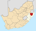 | |
| Nongoma | ||
| Abaqulusi | ||
| uPhongolo | ||
| EDumbe | ||
This KwaZulu-Natal location article is a stub. You can help Wikipedia by expanding it. |
Текст в блоке "Читать" взят с сайта "Википедия" и доступен по лицензии Creative Commons Attribution-ShareAlike; в отдельных случаях могут действовать дополнительные условия.
Другой контент может иметь иную лицензию. Перед использованием материалов сайта WikiSort.org внимательно изучите правила лицензирования конкретных элементов наполнения сайта.
Другой контент может иметь иную лицензию. Перед использованием материалов сайта WikiSort.org внимательно изучите правила лицензирования конкретных элементов наполнения сайта.
2019-2025
WikiSort.org - проект по пересортировке и дополнению контента Википедии
WikiSort.org - проект по пересортировке и дополнению контента Википедии