world.wikisort.org - Pakistan
Matiari District (Sindhi: ضلعو مٽیاري, Urdu: ضلع مٹیاری) is a district in the Pakistani province of Sindh. Located on the left bank of the Indus River, Matiari became an independent district in 2004 under the military regime of Pervez Musharraf, when Hyderabad was divided into four districts — Tando Allahyar, Matiari, Tando Mohammad Khan and Hyderabad.[2]
Matiari District
| |
|---|---|
District of Sindh | |
 Shrine of Shah Abdul Latif Bhittai | |
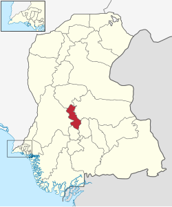 Map of Sindh with Matiari District highlighted | |
| Country | |
| Province | |
| Division | Hyderabad |
| Established | 2005 |
| Headquarters | Matiari |
| Government | |
| • Type | District Administration |
| • Deputy Commissioner | N/A |
| • District Police Officer | N/A |
| • District Health Officer | N/A |
| Area | |
| • Total | 1,417 km2 (547 sq mi) |
| Population (2017)[1] | |
| • Total | 770,040 |
| • Density | 540/km2 (1,400/sq mi) |
| Time zone | UTC+5 (PKT) |
| Number of Tehsils | 3 |
| Website | http://www.matiari.net/ |
This article needs additional citations for verification. (May 2021) |
Etymology
This section does not cite any sources. (May 2021) |
Matiari word is derived from two Sindhi words Mat and yari, which means friendship with earthen water pots.
According to culture, the Main Bus Stop at Matiari Main Road was where a Lady sat in a hut a long time ago. It is where she keeps a mud pot of water. People of Matiari tell the bus conductor "Mat Wari Maai" (Make Stop at Old Women's Hut Where She Keeps Mud Pot of Water). This is apparently why it the district is called Matiari.
History and administration
Matiari district was carved out of Hyderabad district along with Tando Allahyar and Tando Muhammad Khan districts in 2005.[3] Matiari district is part of the Hyderabad division. The district is administratively subdivided into three talukas:[4]
- Hala
- Matiari
- Saeedabad
There are 30 union councils in the district as tabulated below:[5]
| UC
No. |
Name | UC
No. |
Name | UC
No. |
Name | UC
No |
Name | UC
No. |
Name | UC
NO. |
Name |
|---|---|---|---|---|---|---|---|---|---|---|---|
| 1 | Matiari | 6 | Bau Khan
Pathan |
11 | Oderolal
Village |
16 | Bhanoth | 21 | Makhdooman
Jon Landhiyoon |
26 | Bhaledino
Kaka |
| 2 | Jiandal Kot | 7 | Palijani | 12 | Nobat Marri | 17 | Khandu | 22 | Karam Khan
Nizamani |
27 | Sikenderabad |
| 3 | Shah Alam
Ji Wasi |
8 | Oderolal | 13 | Sher Muhammad
Thorra/Kheber |
18 | Fateh
Muhammad Shah Ajnani |
23 | Shahmir
Rahu |
28 | Zair Peer |
| 4 | Shahpur/
Arif Khatian |
9 | Bau Dero | 14 | Faqir Nooh
Hothiani |
19 | Ajan Shah | 24 | Faqirabad | 29 | Abdul Wahid
Borero |
| 5 | Tajpur | 10 | Sekhat | 15 | Muhammad
Hussain Hingoro |
20 | Bhit Shah | 25 | Saeedabad
Old |
30 | Muhammad
Ramzan Unar |
Demography
At the time of the 2017 census, Matiari district had a population of 770,040, of which 396,922 were males and 373,041 females. The rural population was 587,371 (76.28%) and urban 182,669 (23.72%). The literacy rate is 42.63%: 54.05% for males and 38.48% for females.[1]
The majority religion is Islam, with 83.28% of the population. Hinduism (including those from Scheduled Castes) is 16.66% of the population.[1]
At the time of the 2017 census, 92.50% of the population spoke Sindhi, 2.68% Urdu, 1.10% Punjabi and 1.04% Balochi as their first language.[1]
Notable places
This section does not cite any sources. (May 2021) |
The shrines of Pir Rukun-Din-Shah, Makhdoom Sarwar Nooh, Shah Abdul Latif Bhittai, Sakhi Hashim Shah pir Haider shah, Muhammad Faquir Khatian and others are located in Matiari district. Miani forest and the battleground of Sir Charles Napier and Talpur rulers of Sindh and Miani jo Maidan are also situated in Matiari district.
Syed Rukun-Din-Shah also fought a battle with the Arguns dynasty with seven bilalis of sindh.
At Khuda aabad, one can find the graves and the tombs of Mughal Empires era. There is a Masjid (Praying Place) and a well of water.
The Indus River is also there.
Agriculture
This section does not cite any sources. (May 2021) |
Matiari district is one of the most fertile districts of Sindh. The main crops cultivated are cotton, banana, mango, wheat, onions and sugarcane.
Politics
This section does not cite any sources. (May 2021) |
The elected representatives from Matiari district are
- MNA Makhdoom Jameel-uz-Zaman (PPPP) NA 223
- MPA Makhdoom Mehboob Zaman (PPPP) PS 58
- MPA Makhdoom Rafique Zaman (PPPP) PS 59
List of union councils
The following is a list of Matiari District's union councils, organised by Tehsils:[6]
- Hala Tehsil (35 Dehs)
- Matiari Tehsil (49 Dehs)
- Abrejani
- Arain
- Barechani
- Baudero
- Bhanoki
- Bhorko
- Buhryoon
- Chharao
- Dhando
- Ganag Rayati
- Gang Jagir
- Hakra
- Jaheki
- Kaindal Kot
- Jakhri Jagir
- Jakhri Joya
- Jakhri Rayati
- Ketti
- Khorkhani
- Khudi
- Khyberani
- Koheki
- Lutryoon
- Mari
- Matiari
- Mubarak Wah
- Nindero
- Oderolal
- Palijani
- Panhwarki
- Pano
- Porath
- Reechal
- Sadri
- Saeedpur
- Sahib Saman
- Sattar
- Sekhat
- Shahpur
- Sipki Jagir
- Sipki Rayati
- Sohiki
- Soomra
- Sultanpur
- Tajpur
- Thano
- Thorha
- Vesro
- Wassan
- Saeedabad Tehsil (28 Dehs)
- Ahano
- Amin Lakho
- Bawri
- Chhachhri
- Chhapar Kahan
- Chitori
- Dalo Keti
- Dethki
- Fatehpur
- Gadali
- Giss
- Jamali
- Kaka
- Khatoori
- Khuteero
- Koonar
- Larh
- Manahi
- Odiyanoo
- Panjmoro
- Peengharo Jagir
- Peengharo Raieti
- Rahoo
- Rahooki
- Ranoo
- Saeedabad
- Suhrabpur
- Zairpir
Notes
References
- "District-wise Tables - Census 2017 Final Results". pbs.gov.pk. Pakistan Bureau of Statistics. 2017.
- Khan, Mohammad Hussain (2021-09-13). "The vibrant district of Matiari". DAWN.COM. Archived from the original on 2021-10-07. Retrieved 2021-10-08.
- "Three new districts carved out of Hyderabad". TheDawn. 5 April 2005. Archived from the original on 31 July 2021. Retrieved 31 July 2021.
- "NRB: Local Government Elections". nrb.gov.pk. Archived from the original on 26 March 2012. Retrieved 27 January 2012.
- "Matiari District UC List, MNA MPA Seats مٹیاری ضلع کی یونین کونسلز". Political, Sports Workers Helpline. 2017-03-02. Archived from the original on 2019-04-21. Retrieved 2020-02-16.
- "List of Dehs in Sindh" (PDF). Sindh Zameen. Archived (PDF) from the original on 26 February 2021. Retrieved 22 March 2021.
Bibliography
- 1998 District census report of Hyderabad. Census publication. Vol. 59. Islamabad: Population Census Organization, Statistics Division, Government of Pakistan. 1999.
External links
Districts of Sindh | ||
|---|---|---|
Provincial capital: Karachi | ||
| Banbhore |  | |
| Hyderabad | ||
| Karachi | ||
| Larkana |
| |
| Mirpur Khas |
| |
| Sukkur | ||
| Shaheed Benazir Abad |
| |
Authority control | |
|---|---|
| General | |
| National libraries | |
На других языках
[de] Matiari (Distrikt)
Der Distrikt Matiari ist ein Verwaltungsdistrikt in Pakistan in der Provinz Sindh. Sitz der Distriktverwaltung ist die gleichnamige Stadt Matiari.- [en] Matiari District
[ru] Матияри (округ)
Матияри (урду ضلع مٹیاری, англ. Matiari District) — один из 23 округов пакистанской провинции Синд. Административный центр — город Матияри.Другой контент может иметь иную лицензию. Перед использованием материалов сайта WikiSort.org внимательно изучите правила лицензирования конкретных элементов наполнения сайта.
WikiSort.org - проект по пересортировке и дополнению контента Википедии