world.wikisort.org - Norway
Øvre Eiker is a municipality in the traditional and electoral district Buskerud in Viken county, Norway. It is part of the traditional region of Eiker. The administrative centre of the municipality is the village of Hokksund. The old municipality of Eiker was divided into Øvre Eiker (upper Eiker) and Nedre Eiker (lower) on 1 July 1885.
Øvre Eiker kommune | |
|---|---|
Municipality | |
 View of the village of Vestfossen | |
|
Coat of arms  Viken within Norway | |
 Øvre Eiker within Viken | |
| Coordinates: 59°46′19″N 9°50′10″E | |
| Country | Norway |
| County | Viken |
| District | Eiker, Lower Buskerud |
| Administrative centre | Hokksund |
| Government | |
| • Mayor (2009) | Knut Kvale (Centre Party (Norway)) |
| Area | |
| • Total | 457 km2 (176 sq mi) |
| • Land | 418 km2 (161 sq mi) |
| • Rank | #223 in Norway |
| Population (2022) | |
| • Total | 20,250 |
| • Rank | #62 in Norway |
| • Density | 37/km2 (100/sq mi) |
| • Change (10 years) | |
| Demonym | Eikværing[1] |
| Official language | |
| • Norwegian form | Bokmål |
| Time zone | UTC+01:00 (CET) |
| • Summer (DST) | UTC+02:00 (CEST) |
| ISO 3166 code | NO-3048 |
| Website | Official website |
As of 2015, more employees worked for the [municipal] government and in the service sector, than in any other field of employment; even fewer—16 %—are employed in construction or in [electrical] power companies and water companies; [13%] work in the manufacturing sector.[3]
General information
Name
The Old Norse form of the name was Eikjar. The name is the plural form of eiki which means "oak wood". The meaning of Øvre Eiker is "(the) upper (part of) Eiker". (The municipality of Eiker was divided in 1885.)
Coat-of-arms
The coat-of-arms is from modern times. They were granted on 24 October 1981. The arms show three silver oak leaves and two acorns on a blue background. The oak is a canting element, since Eik means oak in the Norwegian language.[4]
(See also coat-of-arms of Eigersund, Nedre Eiker, Songdalen and Tingvoll)
| Ancestry | Number |
|---|---|
| 611 | |
| 267 | |
| 110 | |
| 101 | |
| 96 | |
| 87 | |
| 84 | |
| 75 | |
| 70 | |
| 67 |

Geography
Øvre Eiker is a lush valley along Drammenselva with Modum to the north and Drammen to the east. To the south flows Eikeren watercourse, which is dominated by the contiguous Lakes Eikeren and Fiskumvannet. Eikeren is 156 Meters deep and is partly located in Holmestrand municipality in the south. The municipality's highest point, Myrehogget, 707 meters above sea level.[6] is located west, between Øvre Eiker and Flesberg municipality.[7]
About half of the municipality's inhabitants live in the municipal center Hokksund, which in 2021 had 9,514 inhabitants, the rest live mainly in the settlements Vestfossen, Skotselv, Ormåsen, and Darbu.[8] [9]
The municipality is part of the Drammen region and Buskerudbyen,[10] which is a collaboration within transport, environment and health.[9]
Energy
Hakavik Power Station, startpoint of 55 kV single phase AC grid for traction current.
Notable residents


- Christopher Borgersen Hoen (1767 in Eiker – 1845) farmer and rep. at the Norwegian Constituent Assembly at Eidsvoll in 1814
- Jonas Lie (1833 at Hokksund – 1908) novelist, poet, and playwright
- Olaf Mørch Hansson (1856 in Øvre Eiker – 1912) an actor, theatre director and journalist
- Christopher Hornsrud (1859 in Skotselv – 1960) Prime Minister of Norway in 1928
- Henny Dons (1874 at Aker – 1966) a Norwegian educator and inner missionary
- Hans Dons (1882 in Øvre Eiker – 1940) Navy officer, first manned flight in Norway
- Thina Thorleifsen (1885 in Hokksund – 1959) a politician, active in the women's movement
- Else Halling (1899 in Øvre Eiker – 1987) a Norwegian textile artist
- Harald Henschien (1902 at Øvre Hoen – 1968) accordionist, accordion manufacturer, editor
- Aage Møst (1923 in Skotselv – 2011) a journalist and sports official
- Thorleif Enger (born 1943 in Øvre Eiker) former CEO of Yara International
- Per Olaf Lundteigen (born 1953) farmer and Øvre Eiker municipal councillor 2003/07
- Nikolai Hængsle (born 1978 in Skotselv) a Norwegian bass guitarist, member of BigBang
- Masud Gharahkhani (born 1982) an Iranian-Norwegian politician, brought up in Skotselv
Sport
- Randi Thorvaldsen (1925 in Fiskum – 2011) a champion speedskater in the early 1950s
- Jorunn Horgen (born 1966 in Hokksund) a windsurfer, world champion in 1980's & 90's
- Mona Bollerud (born 1968 in Fiskum) former biathlete, World Championship medallist
- Gustav Wikheim (born 1993 in Hokksund) a Norwegian footballer with over 200 club caps
International relations
Twin towns — Sister cities
The following cities are twinned with Øvre Eiker:
 Kerteminde, Region of Southern Denmark, Denmark[11]
 Lempäälä, Western Finland, Finland[12]
 Ulricehamn, Västra Götaland County, Sweden[13]
Gallery
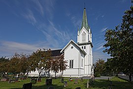 Bakke Church
 Fiskum Church
 Haug Church in Hokksund
 Øksnevann Dam
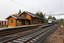 Darbu Station
 Nøstetangen Museum in Hokksund
 Hokksund Station


References
- "Navn på steder og personer: Innbyggjarnamn" (in Norwegian). Språkrådet.
- "Forskrift om målvedtak i kommunar og fylkeskommunar" (in Norwegian). Lovdata.no.
- https://snl.no/%C3%98vre_Eiker "Etter offentlig administrasjon og tjenesteyting er bygge- og anleggsvirksomhet/kraft- og vannforsyning den viktigste næringen i Øvre Eiker målt etter sysselsetting. Denne næringen hadde 16 prosent av kommunens arbeidsplasser i 2015, 29 prosent inkludert industri."
- Norske Kommunevåpen (1990). "Nye kommunevåbener i Norden". Retrieved 2009-01-10.
- "Immigrants and Norwegian-born to immigrant parents". ssb.no. Archived from the original on 2 July 2015. Retrieved 29 July 2017.
- "Myrehogget". www.wikidata.org. Retrieved 2022-07-02.
- "Øvre Eiker – Store norske leksikon". Snl.no. Retrieved 2022-08-13.
- "Tettsteders befolkning og areal".
- "Kommunefakta".
- "Q17760785". www.wikidata.org. Retrieved 2022-07-02.
- "Venskabsbyer" (in Danish). Kerteminde kommune. Retrieved 2009-01-10.
- "Ystävyyskunnat" (in Finnish). Lempäälä. Retrieved 2009-01-10.
- "Föreningen Norden" (in Swedish). Ulricehamn kommun. Retrieved 2009-01-10.
External links
 Media related to Øvre Eiker at Wikimedia Commons
 The dictionary definition of Øvre Eiker at Wiktionary
- Municipal fact sheet from Statistics Norway
 Buskerud travel guide from Wikivoyage
Viken county, Norway | |||||||||||||||||||||||
|---|---|---|---|---|---|---|---|---|---|---|---|---|---|---|---|---|---|---|---|---|---|---|---|
 | Towns and cities |
|  | ||||||||||||||||||||
| Municipalities |
| ||||||||||||||||||||||
| Authority control |
|
|---|
На других языках
- [en] Øvre Eiker
[ru] Эвре-Эйкер
Эвре-Эйкер (норв. Øvre Eiker) — коммуна в губернии Бускеруд в Норвегии. Административный центр коммуны — город Хокксунн. Официальный язык коммуны — букмол. Население коммуны на 2007 год составляло 16 132 чел. Площадь коммуны Эвре-Эйкер — 456,76 км², код-идентификатор — 0624.Другой контент может иметь иную лицензию. Перед использованием материалов сайта WikiSort.org внимательно изучите правила лицензирования конкретных элементов наполнения сайта.
WikiSort.org - проект по пересортировке и дополнению контента Википедии