world.wikisort.org - Netherlands
Noord Deurningen is a village in the Dutch province of Overijssel. It is a part of the municipality of Dinkelland, and lies about 11 km northeast of Oldenzaal.
Noord Deurningen | |
|---|---|
village | |
 Bell tower in Noord Deurningen | |
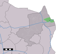 The town centre (dark green) and the statistical district (light green) of Noord Deurningen in the municipality of Dinkelland. | |
 Noord Deurningen Location in the Netherlands  Noord Deurningen Noord Deurningen (Netherlands) | |
| Coordinates: 52°23′49″N 7°1′31″E | |
| Country | Netherlands |
| Province | Overijssel |
| Municipality | Dinkelland |
| Area | |
| • Total | 11.03 km2 (4.26 sq mi) |
| Elevation | 19 m (62 ft) |
| Population | |
| • Total | 1,070 |
| • Density | 97/km2 (250/sq mi) |
| Demonym(s) | Noord-Deurningers |
| Time zone | UTC+1 (CET) |
| • Summer (DST) | UTC+2 (CEST) |
| Postal code | 7591[1] |
| Dialing code | 074 |
Overview
It was first mentioned between 1337 and 1339 as Nortdorningen, and means the north of Deurningen.[3]
In the 17th century the havezate Noorddeurningen was built near the village. In 1875, Franciscan nuns from Thuine in Germany established an orphanage in the estate, and renamed the estate St.-Nicolaasgesticht.[4] In 1840, Noord Deuningen was home to 722 people.[5]
Gallery
 Farm in Noord Deurningen
 Monastery and church
 Art on the border with Germany
 Dutch army moves into Germany (for a joint exercise) (1954)


References
- "Kerncijfers wijken en buurten 2021". Central Bureau of Statistics. Retrieved 15 March 2022.
- "Postcodetool for 7591AA". Actueel Hoogtebestand Nederland (in Dutch). Het Waterschapshuis. Retrieved 15 March 2022.
- "Noord Deurningen - (geografische naam)". Etymologiebank (in Dutch). Retrieved 15 March 2022.
- Ronald Stenvert & Jan ten Hove (1998). "Noord-Deurningen" (in Dutch). Zwolle: Waanders. ISBN 90 400 9200 1. Retrieved 15 March 2022.
- "Noord-Deurningen". Plaatsengids (in Dutch). Retrieved 15 March 2022.
This Overijssel location article is a stub. You can help Wikipedia by expanding it. |
Текст в блоке "Читать" взят с сайта "Википедия" и доступен по лицензии Creative Commons Attribution-ShareAlike; в отдельных случаях могут действовать дополнительные условия.
Другой контент может иметь иную лицензию. Перед использованием материалов сайта WikiSort.org внимательно изучите правила лицензирования конкретных элементов наполнения сайта.
Другой контент может иметь иную лицензию. Перед использованием материалов сайта WikiSort.org внимательно изучите правила лицензирования конкретных элементов наполнения сайта.
2019-2026
WikiSort.org - проект по пересортировке и дополнению контента Википедии
WikiSort.org - проект по пересортировке и дополнению контента Википедии