world.wikisort.org - Netherlands
Deurningen is a village in the Dutch province of Overijssel. It is a part of the municipality of Dinkelland, and lies about 5 km northeast of Hengelo.
Deurningen | |
|---|---|
Village | |
 | |
| Nickname(s): Plagnstekkers | |
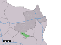 The village centre (dark green) and the statistical district (light green) of Deurningen in the municipality of Dinkelland. | |
 Deurningen Location in the Netherlands  Deurningen Deurningen (Netherlands) | |
| Coordinates: 52°18′24″N 6°50′22″E | |
| Country | Netherlands |
| Province | Overijssel |
| Municipality | Dinkelland |
| Area | |
| • Total | 18.66 km2 (7.20 sq mi) |
| Elevation | 19 m (62 ft) |
| Population (2021)[1] | |
| • Total | 2,015 |
| • Density | 110/km2 (280/sq mi) |
| Demonym(s) | Deurningers |
| Time zone | UTC+1 (CET) |
| • Summer (DST) | UTC+2 (CEST) |
| Postal code | 7561[1] |
| Dialing code | 074 |
Overview
It was first mentioned in 1295 as Thornengen. The etymology is unclear.[3] In 1787 a church was built,[4] and the village developed around the church. The current church was completed in 1912.[5] In 1840, it was home to 719 people.[4] In 2001, 97 houses in Deurningen were transferred to the municipality of Oldenzaal.[4]
Gallery
 Market in Deurningen
 Farm "Oosterhof" in Deurningen


References
- "Kerncijfers wijken en buurten 2021". Central Bureau of Statistics. Retrieved 15 March 2022.
- "Postcodetool for 7561AA". Actueel Hoogtebestand Nederland (in Dutch). Het Waterschapshuis. Retrieved 15 March 2022.
- "Deurningen - (geografische naam)". Etymologiebank (in Dutch). Retrieved 15 March 2022.
- "Deurningen". Plaatsengids (in Dutch). Retrieved 15 March 2022.
- Ronald Stenvert & Jan ten Hove (1998). "Duerningen" (in Dutch). Zwolle: Waanders. ISBN 90 400 9200 1. Retrieved 15 March 2022.
| Authority control |
|
|---|
This Overijssel location article is a stub. You can help Wikipedia by expanding it. |
Текст в блоке "Читать" взят с сайта "Википедия" и доступен по лицензии Creative Commons Attribution-ShareAlike; в отдельных случаях могут действовать дополнительные условия.
Другой контент может иметь иную лицензию. Перед использованием материалов сайта WikiSort.org внимательно изучите правила лицензирования конкретных элементов наполнения сайта.
Другой контент может иметь иную лицензию. Перед использованием материалов сайта WikiSort.org внимательно изучите правила лицензирования конкретных элементов наполнения сайта.
2019-2026
WikiSort.org - проект по пересортировке и дополнению контента Википедии
WikiSort.org - проект по пересортировке и дополнению контента Википедии